


Prakash M Apte, a planner in India, brings us this in-depth and fascinating look at the history of town planning in Gandhinagar, which was developed with an "egalitarian ethos," says Apte, but now it is at risk of becoming "just another suburb."
Either by design or imbecility, the re-planning of Gandhinagar by the Consultants of Gandhinagar Urban Development Authority (GUDA) has obliterated its identity as a capital city. Its consciously designed and planned axial plan & egalitarian, Gandhian ethos has been dismantled. The juggernaut of unbridled capitalism has led to its debasement and inorganic extension resulting in Gandhinagar becoming just another suburb of Ahmedabad.
The city was planned and implemented between 1965-1970 by two Indian planners, H.K.Mewada and P.M.Apte, and an influential group of architects from Ahmedabad with active support from some industrialists. The supporters later tried to usurp the job by bringing in American architect Louis Kahn, who was in Ahmedabad to design the buildings of the management institute. The state government was determined, however, to have the city designed by Indian town planners in the best traditions of Gujarat's rich heritage of town planning and principles of Mahatma Gandhi who had his "Ashram" just south of the proposed site of the city on the banks of river Sabarmati. The government therefore persisted with its choice of Mewada to plan the new capital city.
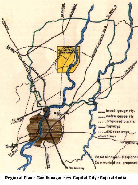
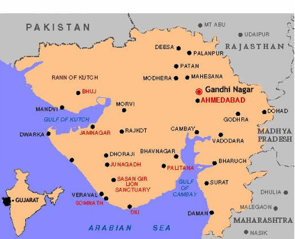
Unlike Chandigarh, designed on barren lands with no sizable existing human settlement near about, Gandhinagar's site is just 23 km. north of Ahmedabad, a flourishing city. To establish and maintain a separate identity for the new city, the surrounding area of about 39 villages was brought under a Periphery Control Act (as in Chandigarh) that permitted new development of farm houses only. The area later constituted a separate administrative district of Gandhinagar.
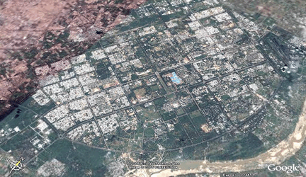
The city is planned on the western bank of the river Sabarmati. Due to a constant military confrontation with Pakistan, whose borders are close from the city, a large military presence was required here. The land acquired on the eastern bank, adjacent to National Highway no.8, was therefore allotted to the Border Security force and military cantonment. Considering the mostly south-west to north-east wind direction, the land to the north of the city was allotted for the then biggest thermal power station and the adjacent areas were zoned for industrial use. This area was distanced from the township by a 2000 ft. wide green strip of thick vegetation. Planned as the administrative capital of the state, the current and future population employed in state government offices was distributed in 30 residential sectors around the State Assembly-Secretariat complex. Each residential sector could accommodate about 50% of population, and was intended to house the half of the population employed by the government. Plots on the periphery of each sector are meant for private and supporting population that constitutes the remaining 50%.
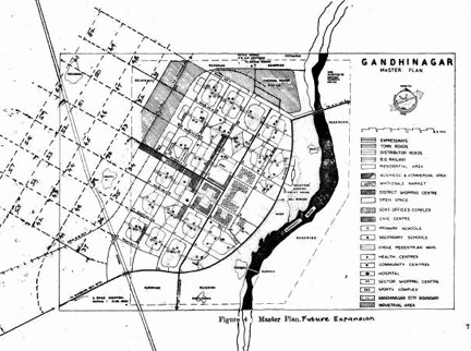
The city was planned for a population of 150,000 but can accommodate double that population with increase in the floor space ratio from 1 to 2 in the areas reserved for private development. The river being the border on the east, and the industrial area to the North, the most logical future physical expansion of the city was envisaged towards the north-west. To retain the identity of the city as a new town and the capital, the planners provided for its growth awayfrom the city of Ahmedabad to the south. Hence, as a rational extension of the grid, the planners had envisaged 30 additional residential sectors to the northwest that could accommodate a population of 450,000. Thus, the growth potential of the city by densification and area expansion to the northwest is for a population of 750,000.
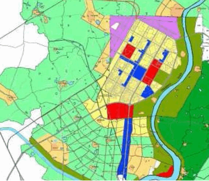
Unfortunately, the consultants recently appointed by GUDA have ignored that history and want the expansion of the city to take place to the south. They saw that the lands between the two cities has a great market value that could be exploited by private developers, and see this as a positive approach.
The consultants failed to review the original city plan and didn't consult planners of the original master plan, thus eliminating the possibility of informed and constructive criticism. The consultants appear to be driven by profit motive, raising serious doubts about their honesty, integrity, and professional competence. A southward expansion proposed by the consultants will merge it with Ahmedabad and finally become its suburb, destroying its separate identity. The consultants are counting on it. Would they have dared to make such proposals if Gandhinagar was designed by Louis Kahn or Le Corbusier?
If the city is to be expanded and extended, it can be done as originally envisioned. It would be rational, in keeping with the original concept, to retain the urban design and the central vista. And yet the plan can absorb new design ideas without destroying the basic concept.
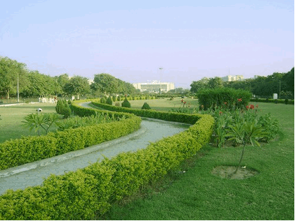
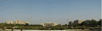
This extension to the south has completely destroyed the plan's most important concept, the central vista (Road no.4). It focuses on the capitol complex, and was naturally to be extended to the north-west maintaining the axis, expanding the city physically in that direction. The location of a Gandhi memorial on this axis, originally provided, has been removed!
The consultants, while extending the city to the south, have designated a 5 km. long and ¼ km. wide belt of land on both sides, of the Koba-Gandhinagar expressway (an area of 2.50 sq.km.) for commercial uses with an FSI of 2.00. This, despite over 50% of the designated commercial area in the city still remaining unsold! Over 6000 acres of green cover to the south west of the city has been designated for residential use in an attempt to join with the city of Ahmedabad. All this land, when developed can accommodate a population of over 600,000. With the connivance of the consultants, the vested interests have bought these lands in advance of the proposals. It will be revealing to know who bought these lands! The consultants thus seek to destroy the identity of the new capital city and make it a suburb of Ahmedabad.
The "Gamthan" (built up land in a village) areas of 7 villages just abutting the city limits of Gandhinagar are increased arbitrarily (much beyond their natural growth requirements) to allow private residential development (who have bought these lands?).These enhanced Gamthan areas together may accommodate a population of over 1,50,000. thus totaling 750,000. Ironically the original plan of Gandhinagar did provide for similar expansion of population and the city area yet retaining its identity, concept and urban design.
The consultants, thus dealing a death blow to the organic growth of Gandhinagar, have helped private developers to get cheap lands to develop commercial & residential apartments with access to free physical infrastructure (roads-water supply etc,) health, education and cultural facilities provided in Gandhinagar by the State Government.
Not content with this abuse of the basic concept, the consultants have dismantled some important urban design features of the plan. A major Area for cultural facilities, in the city square in sector 17 of the city centre is proposed to be converted to commercial use, killing Gujarat's traditional concept of a 'city square' & destroying a major element of 'urban design' of the new capital city.
An area along J road (along the river Sabarmati) across sector 9 covered by ravines, was proposed for conservation as an adventure park. It is now designated by the consultants for residential taking away a unique recreational facility.
The open spaces at the junctions of all main roads of the city, left open in the original plan to improve road geometrics in future, ornamental landscaping, road signage, guide maps etc. are proposed to be filled up with roadside petty shops & hutments for the immigrants giving the city a slum like look. So, the "original" city may look like a slum and the "NEW" a jewel!
A plea to the Chief Minister of Gujarat has not elicited any response so far.
Prakash M Apte is senior town planner for the Gujarat New Capital Project.


Planetizen Federal Action Tracker
A weekly monitor of how Trump’s orders and actions are impacting planners and planning in America.

Chicago’s Ghost Rails
Just beneath the surface of the modern city lie the remnants of its expansive early 20th-century streetcar system.

Amtrak Cutting Jobs, Funding to High-Speed Rail
The agency plans to cut 10 percent of its workforce and has confirmed it will not fund new high-speed rail projects.

Ohio Forces Data Centers to Prepay for Power
Utilities are calling on states to hold data center operators responsible for new energy demands to prevent leaving consumers on the hook for their bills.

MARTA CEO Steps Down Amid Citizenship Concerns
MARTA’s board announced Thursday that its chief, who is from Canada, is resigning due to questions about his immigration status.

Silicon Valley ‘Bike Superhighway’ Awarded $14M State Grant
A Caltrans grant brings the 10-mile Central Bikeway project connecting Santa Clara and East San Jose closer to fruition.
Urban Design for Planners 1: Software Tools
This six-course series explores essential urban design concepts using open source software and equips planners with the tools they need to participate fully in the urban design process.
Planning for Universal Design
Learn the tools for implementing Universal Design in planning regulations.
Caltrans
City of Fort Worth
Mpact (founded as Rail~Volution)
City of Camden Redevelopment Agency
City of Astoria
City of Portland
City of Laramie