America keeps building density that nobody can walk in. We can change that.


America has a density problem, but not the one you think. The problem is not that we lack it. The problem is that we keep building it wrong.
The national housing debate has centered almost entirely on quantity: more units, more approvals, more construction. YIMBY advocates have won important battles in California, Montana and elsewhere, striking down single-family zoning and cutting permitting timelines. These are real wins. But quantity without form produces something that looks like density on a spreadsheet and functions like sprawl on the ground.
Consider two 100-unit apartment buildings near a light rail station. Building A is permitted by right with no parking minimums. But it sits behind a 50-foot setback, a surface parking lot out front, no ground-floor retail and blank walls facing the street. Building B has the same unit count but meets the sidewalk, tucks parking behind the structure, opens a cafe at ground level and puts windows and entrances on the street. Same density. One is a parking lot with apartments above it. The other is a neighborhood.
The difference between building A and building B is not an accident. It is a policy choice. A handful of specific form standards — maximum setbacks, ground-floor activation, parking placement, block size limit — determine whether new density becomes a neighborhood or a parking lot with apartments above it. Three American case studies with a look at international comparators demonstrate why these standards matter and how federal requirements could look.
Tysons Corner: Density without a street grid
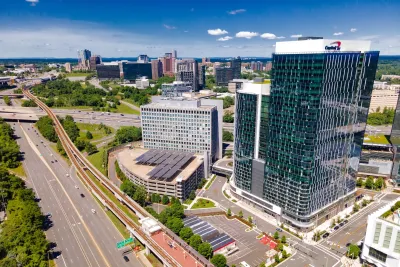
Tysons Corner, Virginia is one of the largest edge cities in America. When four Silver Line Metro stations opened in 2014, the expectation was that Tysons would gradually become a walkable urban center. A decade later, Fairfax County is retrofitting an entire street grid from scratch because no form standards existed when the density arrived. Buildings sit behind parking decks. Sidewalks dead-end into arterials. The distance between Metro exits and building entrances can require a long walk across shadeless parking lots.
Five miles east, Arlington’s Rosslyn-Ballston corridor tells the opposite story. Same Metro system, same region, same decades of development. But Arlington adopted form-based standards alongside its density approvals: maximum setbacks instead of minimums, ground-floor activation requirements, structured parking behind or below buildings. The county decided what it wanted the street to feel like first, then approved the density to match. Tysons is still spending millions trying to reverse-engineer what Arlington built proactively.

Dallas DART: 93 miles of rail, 64 parking lots
Dallas built one of the largest light rail systems in the United States. Most of its 64 stations are still surrounded by surface parking. Mockingbird Station, often cited as a success story, is the exception that proves the rule. It works because the developer chose to build to the sidewalk, mix retail into the ground floor, and activate the street — decisions that no city policy required at other stations. Dallas did not create a TOD policy district until 2008, covering only eight of its then 46 stations. Every other station that lacks those standards looks like what it is: a park-and-ride with a train attached.
Houston: The deregulation paradox
Houston is frequently cited as proof that removing zoning barriers is enough. It has no traditional zoning and has built more housing than places like Atlanta and San Diego. But Houston still mandates minimum lot sizes, wide setbacks and parking. It still typically requires 100-foot arterials. It still separates uses through deed restrictions that function like zoning without the name. The result is a city that is denser than its peers and still almost entirely unwalkable. Houston demonstrates that removing use restrictions is necessary for affordability but not sufficient for walkability.
The international evidence
This pattern is not inevitable. Other countries solved it decades ago.
Japan’s national zoning system uses 12 zones set by the central government, all essentially mixed-use. Where American zoning tells builders exactly what they can build and nothing else is allowed, Japanese zoning defines maximum nuisance levels and permits everything below that threshold. Apartments, small shops, clinics and restaurants appear naturally in residential areas. There is no regulatory distinction between single-family and multifamily homes. Most development happens as-of-right, without discretionary review. Tokyo, one of the densest cities on earth, has among the most affordable housing in the developed world.

European cities take a complementary approach. Copenhagen, for instance, mandates what American planners call form-based standards: buildings must meet the street, blocks must stay short enough for pedestrians to navigate and ground floors must serve the public realm. Barcelona’s superblock program reorganizes entire neighborhoods around pedestrian priority. Copenhagen’s finger plan channels density along transit corridors with strict urban form requirements at each station. These are not exotic planning concepts. They describe how every walkable neighborhood in America was built before mid-century zoning codes made them illegal.
What a federal walkability framework would look like
The fix is not more regulation in the traditional sense. It is replacing regulations that prevent walkability with standards that enable it. A federal walkability framework tied to transit proximity would mandate four specific interventions:
- Maximum setbacks instead of minimums, so buildings meet the sidewalk.
- Block size limits for new large-scale development, so that pedestrians have connected routes instead of superblocks that force every trip onto arterials.
- Ground-floor activation requirements near transit stations, so that streets have destinations worth walking to.
- Parking placement standards that put cars behind or below buildings instead of between the front door and the street.

These standards would apply in graduated tiers based on transit proximity: strictest within a quarter mile of rail and bus rapid transit stations, moderate within a half mile and basic within a mile. Outside those zones, no federal requirements at all. Small towns could voluntarily opt in for their Main Street corridors, accessing the same framework to restore the traditional American town pattern that predates modern zoning. The federal government would publish model code language that jurisdictions could adopt wholesale for automatic compliance. This is not top-down urban planning imposed on rural communities. It is giving communities that want walkability the legal tools to build it.
Why this appeals across political lines
This framing is deliberately difficult to place on a left-right spectrum. For conservatives, it is deregulatory: replacing prescriptive setback minimums and parking mandates with form standards that expand what property owners can build. For progressives, it is a climate and equity win: walkable neighborhoods reduce car dependence, cut emissions and make transit investments actually function. For developers, it offers something rare in American land use: predictability. Clear form standards applied by right, without discretionary review boards, mean faster approvals and lower risk.
The YIMBY movement is right that we need to remove barriers to building. But removing barriers is a necessary condition for walkable density, not a sufficient one. Tysons, Dallas, and Houston all demonstrate that America is fully capable of building dense and car-dependent at the same time. Getting density right requires one more step: ensuring that what gets built is actually a neighborhood, not just a collection of tall buildings you have to drive between.


Planetizen Federal Action Tracker
A weekly monitor of how Trump’s orders and actions are impacting planners and planning in America.

Amtrak, CN end decades-long dispute with eight-year agreement
The new operating agreement establishes an updated framework for the companies to work together, including processes to resolve disputes.

Judges permit Denver to divert 77,000 acre feet from the Colorado River for reservoir expansion
Overuse and climate change have caused the Colorado River’s water levels to plummet.
NYC DOT wants faster, more permanent street upgrades
The city is examining ways to build more concrete infrastructure without getting entangled in 'decades-long' projects.

'Something we’ve never seen before:' rising utility rates could strain city finances nationwide
Data centers, climate change and other factors have caused utility rates in the United States to increase by 38% since 2020.

Trump to overrule local leaders, lease millions of acres of America’s Pacific Island territories’ seafloors to mining companies
International law says that the Indigenous people of America’s territories have a right to prior and informed consent regarding projects that impact their countries.

FREE Course: Walkable City 1: Why Walkability?
After describing his path towards focusing on walkability as the essence of good planning, Jeff Speck marches through his five principal reasons for making more walkable places.
Reinventing Malls: Planning Alchemy—Turning Gray Fields Into Gold
The course focuses on the opportunities and imperatives that shape reinvention of mall sites.

Harvard University Graduate School of Design
KFH Group Inc.
Greater Baltimore Committee
The Architects Foundation
University of Cincinnati Online
The Pocatello Development Authority
The Urban Renewal Agency of the City of Pocatello

