It is indeed possible to have a city full of low-rise buildings that is still compact enough for excellent transit service—but only if most side streets are used for mid-rise buildings instead of houses.



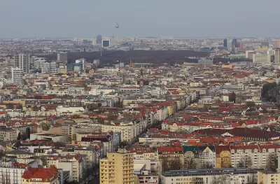
Many urbanists, especially those who dislike tall buildings, are eager to point out that a city can have dense, transit-oriented development without having lots of tall buildings. And when I visited Europe last month, I saw some excellent examples of low-rise yet compact places. Most of central Paris, for example, is dominated by four- and five-story buildings, yet Paris is actually denser than New York City. The older parts of Berlin and Amsterdam have a similar urban fabric.
Does this mean that American cities will be as walkable and transit-friendly as Paris if they halt the construction of tall buildings? Not exactly.
Here’s why: in the parts of central Paris and central Berlin that I visited, every single block was dominated by mid-rise buildings—not just busy multi-lane boulevards, but quiet residential streets as well. So if you walk through Charlottenberg (an affluent Berlin neighborhood) you will see street after street after street of three-to-five story buildings.
By contrast, no U.S. city outside Manhattan has a similar level of density on its side streets. Even New York's outer boroughs have some streets with lots of mid-rises, but many others that are dominated by single-family homes or rowhouses. And in less compact American cities, the overwhelming majority of streets are dominated by single-family homes. So to have a European level of density, a city must either rezone all of its side streets to allow lots of multi-story, multi-family low-rise buildings, or allow taller buildings on its main streets.
For example, Charlottenberg has 118,704 people living in about 2,500 acres (that is, four square miles). Thus, it has slightly over 47 people per acre, fairly evenly distributed across the neighborhood’s blocks. Suppose that 2,300 of these acres were magically turned into a walkable American streetcar suburb—for example, Atlanta’s Virginia Highlands, a walkable neighborhood dominated by single-family homes. Virginia-Highlands has 7,800 inhabitants living on 612 acres, or 12 people per acre, so the population of these 2,300 acres would be reduced from 108,000 to just under 28,000. To avoid reducing neighborhood-wide density, the other 200 acres would have to be upzoned to support about 80,000 additional inhabitants—which means that instead of having around 10,000 inhabitants, the neighborhood’s most dense streets would have 90,000 people, or almost 450 per acre, a significantly higher level of density than Manhattan.* Could you have 450 people per acre without having some high-rises? I doubt it.
In sum, you might want a city with Paris/Berlin densities, streets full of single-family homes, and without high-rises. But in fact, you can only have two of the three. You can have a dense low-rise city, but only if almost all of the streets were dominated by multi-story buildings (the European option). Or you can have a city with single-family zoning and fairly high density, but only if you have lots of tall buildings on the multifamily blocks.
*Manhattan has 51 households per acre, or roughly 100-150 human beings per acre. However, some blocks in my Manhattan neighborhood (Murray Hill) have 100-150 households per acre, which is a bit closer to this density level.
Yet again, Seattle’s density zoning update is hit with delays
The city must now examine the ‘maximum possible development’ under a future zoning scenario, rather than the ‘maximum likely development.’
To upzone or not to upzone? Two views on the housing crisis
Allowing more density can increase the housing supply, but does the attendant rise in land prices cancel out the benefits?
Controversial Texas housing law has 'directly facilitated' over 1,250 new homes
SB 840 allows developers to build multifamily housing by-right on lots zoned for commercial use without applying to a zoning change.

Planetizen Federal Action Tracker
A weekly monitor of how Trump’s orders and actions are impacting planners and planning in America.
Washington state to charge fee to drivers with fuel-efficient cars
Revenue from the fee will go towards supporting the state’s highways.
Illinois considers spending $1 billion in taxpayer money on data center
A quantum computing campus and data center are currently under construction in Chicago.

‘Demolition of our heritage:’ Some US tribes speak out against BAAJA
A coalition of indigenous groups in the United States are concerned about provisions in the bill that may weaken their ability to halt large energy projects.

How LA’s new mayor plans to tackle affordable housing crisis
Mayor-elect Nithya Raman has proposed overhauling the city’s permitting process.

Interactive map reveals Pennsylvania's abandoned oil, gas wells — many on residential property
It is difficult for residents to know if a well is near their home, or if it poses a threat to them.

FREE Course: Walkable City 1: Why Walkability?
After describing his path towards focusing on walkability as the essence of good planning, Jeff Speck marches through his five principal reasons for making more walkable places.
Reinventing Malls: Planning Alchemy—Turning Gray Fields Into Gold
The course focuses on the opportunities and imperatives that shape reinvention of mall sites.

City of Charlotte
City of Rosemead
Rutgers University, Edward J. Bloustein School of Planning and Public Policy
University of Michigan School for Environment and Sustainability (SEAS)
Hunter College, City University of New York (CUNY)
The Architects Foundation
University District Partnership


