


A short guide to a few of Detroit's historic neighborhoods.


Last weekend, I was at the 24th Congress for the New Urbanism in Detroit. Near the end of the conference, I overheard someone saying: "I wish there was a guide to Detroit, like Lonely Planet or something." Even though I didn't see enough of Detroit to create a book-length guide, I think I saw enough for a blog post. So I thought I would write one.
I started off walking around downtown Detroit; downtown has apparently improved over the past few years, and seemed to me to be the most attractive part of the city. Although a few of the city’s historic office buildings are still unoccupied, many are now used either as offices or as residences, and others are clearly in the process of being rehabilitated. In addition, downtown has some interesting public spaces, most notably the Campus Martius park, which has a sandbox, a basketball court and other attractions. At the southern tip of downtown is the surprisingly blue Detroit River. On the negative side, the river is separated from the rest of downtown by Jefferson Avenue, a high-speed street (or stroad) with four lanes of traffic in each direction.
A few interesting neighborhoods are within walking distance (more or less) of downtown. The leafy Lafayette Park neighborhood, just east of downtown, is one of the better examples of mid-century "Towers in the Park" design; it includes both two-story townhouse units and high-rises designed by Mies Van Der Rohe. While mid-century construction is often unattractive, Lafayette Park's walkways and generous tree canopy actually make it seem parklike. On the negative side, I might be reluctant to live there if I lived in Detroit, because to get there from downtown, I walked through some blocks that seemed desolate even during the daytime.
Just northeast of downtown is an even more unusual area, Brush Park. This area is full of 19th-century Victorian mansions, only about a quarter of which survive. Because Brush Park deteriorated during the 20th century, much of the neighborhood is urban prairie—that is, some of the houses were destroyed, and their yards reverted to nature. But today, the neighborhood is being revitalized; some of the mansions are being rehabilitated, while once-empty blocks are filling up with new houses and condos. As a result, Brush Park is currently an interesting mix of progress and decay: some blocks are full of new houses, while others have a Victorian or two surrounded by prairie. I suspect that a decade or two from now, every inch of Brush Park will be inhabited. I wonder if the people who stay there till the 2030s will miss the old days of one or two houses per block.
A more conventional 19th-century neighborhood, Corktown, is about a 15 or 20 minute walk west of downtown. Corktown is dominated by small Victorian houses; my sense is that in 1900 it was a poorer area than Brush Park. Unlike Brush Park, it is mixed-use: our group did a Corktown pub crawl last week. On the negative side, the neighborhood’s main street, Michigan Avenue, is another of these huge streets that aren’t really much fun to cross, and the walk from downtown to Corktown involves some pretty desolate blocks. (I walked to Corktown before dark, but took a cab at night because those blocks gave me the willies.)
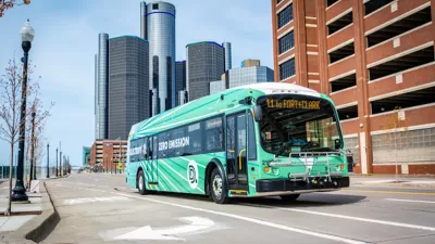
In addition to visiting areas within walking distance of downtown, I sampled local buses. I limited my urban bus use to the Woodward Avenue bus (bus 53), because the buses run every ten minutes during the day. By contrast, most Detroit buses seem to run much less frequently.
Woodward is another gigantic stroad, and is mostly bounded by poor areas. So if (unlike me) you are brave enough to explore lots of urban prairie, Woodward is as good a street as any to start with. But there are a few relatively prosperous areas off Woodward. Midtown Detroit, just north and west of Brush Park, includes a Whole Foods, a few new apartment buildings, most of the city’s museums, and Wayne State University. In addition, the more sterile New Center area north of Wayne State includes the Fisher Building (an art deco skyscraper/theatre) and numerous office buildings.
A few miles further north, just west of the 9300 block of Woodward, is the Boston-Edison historic district, full of 1920s mansions. (Henry Ford briefly lived in the neighborhood, at 140 Edison Avenue.) But unlike similar areas in more prosperous cities, Boston-Edison is not surrounded by walkable retail; instead, the retail near this area looks just like the rest of Woodward Avenue—that is, suburban and poor.
Still further north, at Seven Mile Road, is the Palmer Woods historic district—another wealthy 1920s area. Like Boston-Edison, Palmer Woods is not surrounded by walkable retail, and the area across Woodward from Palmer Woods looks quite distressed.
Ultimately, the Woodward Avenue bus terminates at a transit center at the city edge, where you can take buses to the suburbs (as I did one morning). The area has separate bus systems for the city and the suburbs; the Detroit Department of Transportation serves the city, and a separate agency called SMART serves the suburbs. The SMART bus I took (serving the suburb of Oak Park) runs every 45-60 minutes till about 10 PM. As a general matter,Detroit bus service seems roughly comparable to the much smaller area of Jacksonville,Florida (where I lived from 2006-11): bus routes serve a big chunk of suburbia, run into the evening but not until midnight, and tend to run every 30-60 minutes.
A Summary of CNU24 Detroit
Miss the Congress for the New Urbanism in Detroit? Hazel Borys shares some highlights, with help from Twitter urbanists.
$817 Million Safe Streets Grants Include $25M for Detroit
The city plans to use the funds to make safety and accessibility improvements at bus stops.

Detroit Launches Duplex Repair Program
The grants will help landlords repair aging multifamily affordable housing.

Pennsylvania Mall Conversion Bill Passes House
If passed, the bill would promote the adaptive reuse of defunct commercial buildings.

World's Largest Wildlife Overpass In the Works in Los Angeles County
Caltrans will soon close half of the 101 Freeway in order to continue construction of the Wallis Annenberg Wildlife Crossing near Agoura Hills in Los Angeles County.

Coming Soon to Ohio: The Largest Agrivoltaic Farm in the US
The ambitious 6,000-acre project will combine an 800-watt solar farm with crop and livestock production.

California Grid Runs on 100% Renewable Energy for Over 9 Hours
The state’s energy grid was entirely powered by clean energy for some portion of the day on 37 out of the last 45 days.

New Forecasting Tool Aims to Reduce Heat-Related Deaths
Two federal agencies launched a new, easy-to-use, color-coded heat warning system that combines meteorological and medical risk factors.

AI Traffic Management Comes to Dallas-Fort Worth
Several Texas cities are using an AI-powered platform called NoTraffic to help manage traffic signals to increase safety and improve traffic flow.
City of Costa Mesa
Licking County
Barrett Planning Group LLC
HUD's Office of Policy Development and Research
Mpact Transit + Community
HUD's Office of Policy Development and Research
Tufts University, Department of Urban and Environmental Policy & Planning
City of Universal City TX
ULI Northwest Arkansas
Write for Planetizen
Urban Design for Planners 1: Software Tools
This six-course series explores essential urban design concepts using open source software and equips planners with the tools they need to participate fully in the urban design process.
Planning for Universal Design
Learn the tools for implementing Universal Design in planning regulations.