


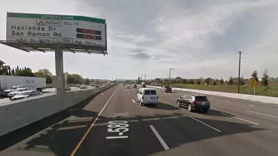
This will not be a revolution against freeways, as some may have hoped, but a revolution marked by new express lanes totaling 550 miles, beginning with a new stretch of 14 miles on I-580 through Dublin, Pleasanton, and Livermore in the East Bay.
For the uninitiated, express lanes* are not lanes on an expressway. In California and throughout much of the United States, express lanes are the new term to replace high occupancy toll (HOT) lanes that enable solo drivers who have transponders in their vehicles allowing them to be charged a toll, more often than not varying with the level of congestion, to drive on lanes heretofore restricted to carpoolers, who can still travel at no charge. [See FAQ for Bay Area Express Lanes [PDF].
Gary Richards of the San Jose Mercury News calls it "the dawning of an era of highway express lanes." Michael Cabanatuan of the San Francisco Chronicle sees the new express lanes, due to open sometime this month, as heralding "a freeway revolution." Clearly the two major Bay Area newspapers are of the same mind: express lanes are to freeways what the iron horse was to the domestic horse, and should be celebrated in the same vein.

Credit: MTC: I-580 Express Lanes Map
The Alameda County Transportation Commission (ACTC), the builder and operator of the new express lanes, is more to the point—describing the new stretch of express lanes as representing "the 'next generation' of express lanes in the Bay Area" in their media advisory [PDF].
What's revolutionary or 'next generation'?
While the I-580 Express Lanes are not the first express lanes in the Bay Area, they are the first to "feature near continuous access, so drivers can enter at almost any point instead of waiting for dedicated entry and exit zones," notes ACTC's press release [PDF].
Adds Cabanatuan, the Chronicle's transportation reporter, they "are the first in the state to allow drivers to mostly enter and lever where they please."
- In addition, these will be the first express lanes in the Bay Area that carpoolers will be required to have a FasTrak Flex transponder which "will allow drivers to indicate how many people are inside their vehicle so carpoolers get a free ride -- which the older transponders can't do," writes Richards, aka Mr. Roadshow, for the Mercury News. In addition, "motorcycles, and eligible clean air vehicles will need a FasTrak Flex toll tag," according to FasTrak.
- Tolls range from $2.10 to $13 depending on congestion level and direction from 5 a.m. to 8 p.m., Monday to Friday. "Outside of those hours, they'll be open to general traffic", writes Cabanatuan.
- The other notable aspect is the sheer number of express lanes planned. "Within another decade, about 300 miles worth of toll lanes will be rolled out in the region," writes Richards.
According to the Bay Area's regional planning agency, the Metropolitan Transportation Commission (MTC), plans are underway to "convert 150 miles of existing High Occupancy Vehicle (HOV) lanes to express lanes and add 120 miles of new lanes to close network gaps."
The "revolutionary" I-580 Express Lanes are three new lanes, not HOV lane conversions, built "from the ground up," two eastbound and one westbound according to Cabanatuan.
Ultimately there will be a 550-mile network of express lanes in the Bay Area operated by ACTC, the Santa Clara Valley Transportation Authority and MTC, all using FasTrak Flex.
The I-580 Express Lanes are the Bay Area's third express lanes. In operation are:
- I-680 Express Lanes: a 14-mile stretch of southbound I-680 from State Route 84 south of Pleasanton to State Route 237 in Milpitas, also operated by ACTC.
- SR 237 Express Lanes in Santa Clara County, built and operated by the Santa Clara Valley Transportation Authority
KQED's Forum covered the new lanes on Feb. 11 in a half-hour call-in radio show with guests Tess Lengyel, ACTC deputy director of policy and planning, and Michael Cabanatuan of The Chronicle.
*The I-405 Express Toll Lanes that opened last September in the Seattle area deserve an award if for nothing less than truth in labeling—no other express lanes to my knowledge, actually uses the term 'toll.'
FULL STORY: New I-580 toll lanes: FasTrak Flex required for all drivers
Bay Area Express Lanes Turn a Profit
Not all of them, just the I-580 lanes. One of the reasons is that most users are actually paying, unlike the other two express lanes where a majority of users are clean-air vehicles or carpools, neither of which pay.
Bay Area's Newest Express Lanes Opened Monday
Due to the high level of existing congestion, the Metropolitan Transportation Commission warns motorists that the new I-680 Contra Costa Express Lanes will offer relief just before and after the peak commute hour.
First Bay Area Express Lanes Approved For New Bay Area Agency
The Bay Area already has express lanes - but these 23 miles in Contra Costa County on I-680 will be the first built and operated by the new Bay Area Infrastructure Financing Authority, a division of the Metropolitan Transportation Commission (MTC).

Depopulation Patterns Get Weird
A recent ranking of “declining” cities heavily features some of the most expensive cities in the country — including New York City and a half-dozen in the San Francisco Bay Area.

California Exodus: Population Drops Below 39 Million
Never mind the 40 million that demographers predicted the Golden State would reach by 2018. The state's population dipped below 39 million to 38.965 million last July, according to Census data released in March, the lowest since 2015.

Chicago to Turn High-Rise Offices into Housing
Four commercial buildings in the Chicago Loop have been approved for redevelopment into housing in a bid to revitalize the city’s downtown post-pandemic.

New Park Opens in the Santa Clarita Valley
The City of Santa Clarita just celebrated the grand opening of its 38th park, the 10.5-acre Skyline Ranch Park.

U.S. Supreme Court: California's Impact Fees May Violate Takings Clause
A California property owner took El Dorado County to state court after paying a traffic impact fee he felt was exorbitant. He lost in trial court, appellate court, and the California Supreme Court denied review. Then the U.S. Supreme Court acted.

How Urban Form Impacts Housing Affordability
The way we design cities affects housing costs differently than you might think.
City of Costa Mesa
Licking County
Barrett Planning Group LLC
HUD's Office of Policy Development and Research
Mpact Transit + Community
HUD's Office of Policy Development and Research
City of Universal City TX
ULI Northwest Arkansas
Town of Zionsville
Urban Design for Planners 1: Software Tools
This six-course series explores essential urban design concepts using open source software and equips planners with the tools they need to participate fully in the urban design process.
Planning for Universal Design
Learn the tools for implementing Universal Design in planning regulations.