


Seattle continues to expand its efforts to improve walkability with the Safe Routes to School Program.
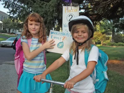
In Seattle, 83 percent of public school students live within their school's official walk zone, but only 24 percent are walking or bicycling to school. "A huge amount of peak-hour traffic is just for school drop-off and pick-up," reports Tom Fucoloro. This creates a catch-22, he explains: parents are afraid to let their kids walk or bike to school, so they drive them, thus contributing to the car traffic and creating a more dangerous space for walkers and bicyclists.
As part of the city's new Vision Zero plan to eliminate all traffic-related deaths, the Safe Routes to School program will be expanded to include 3rd, 4th, and 5th grade education on biking and walking for all public school students; safety improvements for sidewalks and crosswalks; and strategies for long-term infrastructural investments. The plan emphasizes the importance of reduced speed limits, citing numerous statistics comparing the dangers of 20 mph vs. 30-40 mph speed limits. For example, nine out of ten pedestrians hit by a car traveling at 20 mph will survive; only one out of ten will survive the impact at 40 mph.
"The grassroots powering the plan make it one of the best collections of ideas you will find in any road safety plan," writes Fucoloro.
FULL STORY: How Seattle plans to fuel its grassroots walk-and-bike-to-school revolution

The Most Bike-Friendly States in the Nation
The League of American Bicyclists ranks states based on bike infrastructure and safety efforts.
Which Cities Have the Highest Pedestrian Fatalities?
Rapid population growth and limited pedestrian infrastructure puts people walking at higher risk.

Houston Developers Question Mayor’s Stance on Pedestrian Projects
The new mayor’s reversal of road safety projects, some already underway or completed, is raising eyebrows among developers who say residents want walkable, mixed-use streets.

Planetizen Federal Action Tracker
A weekly monitor of how Trump’s orders and actions are impacting planners and planning in America.

Congressman Proposes Bill to Rename DC Metro “Trump Train”
The Make Autorail Great Again Act would withhold federal funding to the system until the Washington Metropolitan Area Transit Authority (WMATA), rebrands as the Washington Metropolitan Authority for Greater Access (WMAGA).

The Simple Legislative Tool Transforming Vacant Downtowns
In California, Michigan and Georgia, an easy win is bringing dollars — and delight — back to city centers.

The States Losing Rural Delivery Rooms at an Alarming Pace
In some states, as few as 9% of rural hospitals still deliver babies. As a result, rising pre-term births, no adequate pre-term care and "harrowing" close calls are a growing reality.

The Small South Asian Republic Going all in on EVs
Thanks to one simple policy change less than five years ago, 65% of new cars in this Himalayan country are now electric.

DC Backpedals on Bike Lane Protection, Swaps Barriers for Paint
Citing aesthetic concerns, the city is removing the concrete barriers and flexposts that once separated Arizona Avenue cyclists from motor vehicles.
Urban Design for Planners 1: Software Tools
This six-course series explores essential urban design concepts using open source software and equips planners with the tools they need to participate fully in the urban design process.
Planning for Universal Design
Learn the tools for implementing Universal Design in planning regulations.
Smith Gee Studio
City of Charlotte
City of Camden Redevelopment Agency
City of Astoria
Transportation Research & Education Center (TREC) at Portland State University
US High Speed Rail Association
City of Camden Redevelopment Agency
Municipality of Princeton (NJ)