


A recently released tool for analyzing the efficiency of travel modes in cities around the country reveals that driving is almost always a better choice—at least in travel time—than transit.
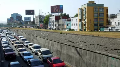
Emily Badger follows up on a set of visualization tools recently released by the MIT Media Lab on the You Are Here website:
"Two things are particularly striking [about the visualizations]: Cycling is a much more efficient mode of transportation than many people realize. And transit is startlingly not so. Seldom will it get you farther, faster, than a bike will." Moreover, "[very] little of the city — just one tiny patch of it — is accessed fastest by transit. This picture would no doubt look different if we removed bikes from the calculation entirely and simply compared cars and transit. But even then, the city would still look more broadly accessible to you from behind the wheel of a car."
As Badger points out, that trend holds true in many of the country's largest cities, and, thus, "these maps illustrate why people make rational calculations to drive so much of the time, even in cities where decent transit does exist."
Badger goes on to cite Manhattan as a model for what it takes to bring the efficiency of transit in line with that of the automobile.
FULL STORY: Why cars remain so appealing even in cities with decent public transit


Improved Service Speeds Up Buses, Increases Ridership
The data on select bus service (SBS) in the Metropolitan Transportation Authority bus system are definitive: with off-board payment and bus-only lanes, buses perform better and attract more riders.
Speeding Up Trains and Improving Traffic Safety in San Jose
At-grade light rail has a hard time safely and efficiently traversing Downtown San Jose on Second Street. A new pilot project will look to improve the situation.
The Value of Fast Transit—Under Construction in Paris
The proposed Grand Paris Express program, which began construction this summer and is expected for completion in 2030, will serve 2 million people a day at "wildly fast speeds." Then there's light rail in the United States.

Maui's Vacation Rental Debate Turns Ugly
Verbal attacks, misinformation campaigns and fistfights plague a high-stakes debate to convert thousands of vacation rentals into long-term housing.

Planetizen Federal Action Tracker
A weekly monitor of how Trump’s orders and actions are impacting planners and planning in America.

In Urban Planning, AI Prompting Could be the New Design Thinking
Creativity has long been key to great urban design. What if we see AI as our new creative partner?

How Trump's HUD Budget Proposal Would Harm Homelessness Response
Experts say the change to the HUD budget would make it more difficult to identify people who are homeless and connect them with services, and to prevent homelessness.

The Vast Potential of the Right-of-Way
One writer argues that the space between two building faces is the most important element of the built environment.

Florida Seniors Face Rising Homelessness Risk
High housing costs are pushing more seniors, many of them on a fixed income, into homelessness.
Urban Design for Planners 1: Software Tools
This six-course series explores essential urban design concepts using open source software and equips planners with the tools they need to participate fully in the urban design process.
Planning for Universal Design
Learn the tools for implementing Universal Design in planning regulations.
Gallatin County Department of Planning & Community Development
Heyer Gruel & Associates PA
JM Goldson LLC
Mpact (founded as Rail~Volution)
City of Camden Redevelopment Agency
City of Astoria
Jefferson Parish Government
Camden Redevelopment Agency
City of Claremont