


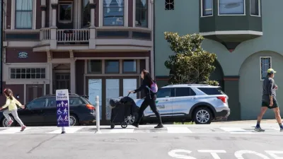
With its own “Vision Zero” goals in place to eliminate pedestrian fatalities within a decade, San Francisco has developed the WalkFirst plan to target the most dangerous intersections in the city for safety improvements.
Jessica Kwong reports on the unveiling of a five-year program, called WalkFirst, to improve safety at San Francisco’s least safe intersections.
Targetting intersections in downtown, the Tenderloin, and South of Market, “WalkFirst seeks to implement a Pedestrian Safety Capital Improvement Program to address corridors and intersections that represent 6 percent of city street miles but account for 60 percent of severe and fatal injuries.”
The city will require more funding to cover the costs of the program. “But the $17 million over five years secured so far for WalkFirst is not enough to cover the improvements needed. Measures in the works for the November ballot could boost that to $50 million, which would cover the capital improvement program costs, but $240 million is needed to implement all the needed projects under the initiative.”
The $17 million the city has to spend in the next five years? That’s about what the city spends treating pedestrian injuries every year, according to Walk San Francisco Executive Director Nicole Schneider.
FULL STORY: SF announcing more plans to boost pedestrian safety

San Francisco Slow Streets Bucks Citywide Trend, Reducing Injuries by 61 Percent
Low-cost interventions aimed at slowing traffic are making a major impact on road safety.
San Francisco Implements ‘Daylighting’ at Intersections
Vehicles are prohibited from parking within 20 feet of a crosswalk as part of the city’s Vision Zero efforts to eliminate traffic deaths and make roads safer.

San Francisco Moves to Ban Right Turns on Red
The policy is common in many countries, New York City, and other dense urban areas with high numbers of pedestrians and cyclists.

Planetizen Federal Action Tracker
A weekly monitor of how Trump’s orders and actions are impacting planners and planning in America.

Map: Where Senate Republicans Want to Sell Your Public Lands
For public land advocates, the Senate Republicans’ proposal to sell millions of acres of public land in the West is “the biggest fight of their careers.”

Restaurant Patios Were a Pandemic Win — Why Were They so Hard to Keep?
Social distancing requirements and changes in travel patterns prompted cities to pilot new uses for street and sidewalk space. Then it got complicated.

DC Area County Eliminates Bus Fares
Montgomery County joins a growing trend of making transit free.

Platform Pilsner: Vancouver Transit Agency Releases... a Beer?
TransLink will receive a portion of every sale of the four-pack.

Toronto Weighs Cheaper Transit, Parking Hikes for Major Events
Special event rates would take effect during large festivals, sports games and concerts to ‘discourage driving, manage congestion and free up space for transit.”
Urban Design for Planners 1: Software Tools
This six-course series explores essential urban design concepts using open source software and equips planners with the tools they need to participate fully in the urban design process.
Planning for Universal Design
Learn the tools for implementing Universal Design in planning regulations.
Heyer Gruel & Associates PA
JM Goldson LLC
Custer County Colorado
City of Camden Redevelopment Agency
City of Astoria
Transportation Research & Education Center (TREC) at Portland State University
Camden Redevelopment Agency
City of Claremont
Municipality of Princeton (NJ)