


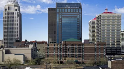
Recent analysis shows that Louisville, Ky. suffers from the worst 'heat island' conditions among America's 50 largest cities. The city is also one of the few without a tree ordinance. Coincidence? Sarah Goodyear investigates.
Goodyear looks at the work of Brian Stone of the Urban Climate Lab at Georgia Tech, one of the country's leading researchers on the urban "heat island" effect — "the difference between the temperature of a major metro area and the surrounding countryside."
"Last year, he and his colleagues released an analysis of data [PDF] from the 50 largest cities in America. And it came as something of a surprise that Louisville, Ky. had the unhappy distinction of being on top."
"The average increase in the temperature difference between urban and rural environments in the Louisville area has been 1.67 degrees Fahrenheit every decade between 1961 and 2010," explains Goodyear. "That’s nearly double the rate of the next city on the list, Phoenix, which saw an average change of .96 degrees in the same period."
In addition to "the unfortunate meteorological conditions" of the Ohio River Valley, "another likely contributing factor is the lack of tree cover in Louisville," she notes.
“The tree canopy downtown is one of the sparsest of any city I have seen in the country,” Stone said. "The tree cover in Louisville’s larger metro area is around 30 percent, according to Stone’s research [PDF], with the urban core at just 10 percent. That compares to about 45 percent in the city of Atlanta."
"And that lack of greenery — unlike Ohio River Valley weather patterns or global warming — is something that Louisville’s municipal leaders could change."
FULL STORY: There Are Few Trees in Louisville, America’s Hottest City

Planting More Trees to Protect and Save Lives
A new study estimates that more than a third of premature deaths from excessive heat can be prevented by planting more trees in cities.

Research Shows Urban Trees Stave off Depression
A new study shows that regular exposure to trees and green spaces has a powerful impact on depression and mental health.

Louisville Gearing Up to Tackle its Urban Heat Island Problem
Louisville has the ignominious distinction of having the largest heat island effect of any of the largest cities in the United States. A new study from the Urban Climate Lab at Georgia Tech suggests ideas for lowering the heat in the city.

Depopulation Patterns Get Weird
A recent ranking of “declining” cities heavily features some of the most expensive cities in the country — including New York City and a half-dozen in the San Francisco Bay Area.

California Exodus: Population Drops Below 39 Million
Never mind the 40 million that demographers predicted the Golden State would reach by 2018. The state's population dipped below 39 million to 38.965 million last July, according to Census data released in March, the lowest since 2015.

Chicago to Turn High-Rise Offices into Housing
Four commercial buildings in the Chicago Loop have been approved for redevelopment into housing in a bid to revitalize the city’s downtown post-pandemic.

How Urban Form Impacts Housing Affordability
The way we design cities affects housing costs differently than you might think.

The State of E-Scooters in the US
Eight years after shared e-scooters were first introduced in US cities, the industry still teeters on the edge of success, hindered in part by limited infrastructure.

Rochester Shows Possible Future for Former Highways
A former freeway is undergoing a massive redevelopment that goes beyond highway removal to reconnect and revitalize surrounding areas.
City of Costa Mesa
Licking County
Barrett Planning Group LLC
HUD's Office of Policy Development and Research
Mpact Transit + Community
HUD's Office of Policy Development and Research
City of Universal City TX
ULI Northwest Arkansas
Town of Zionsville
Urban Design for Planners 1: Software Tools
This six-course series explores essential urban design concepts using open source software and equips planners with the tools they need to participate fully in the urban design process.
Planning for Universal Design
Learn the tools for implementing Universal Design in planning regulations.