


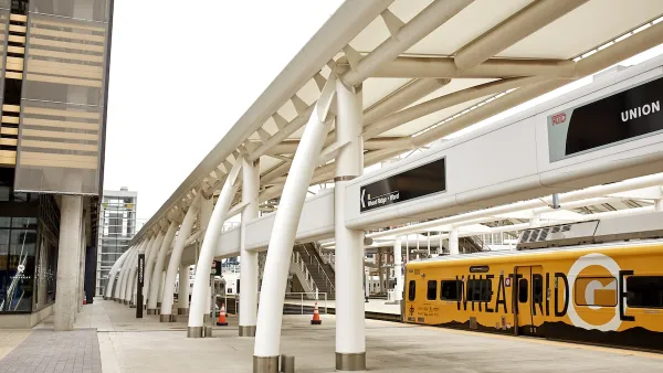
With a new area plan oriented around the arrival of Denver's West Light Rail line, planners are hoping to spur a transformation of the city's Sun Valley neighborhood. Can the area diversify without displacing existing residents?
Located adjacent to the stadium for the NFL's Broncos on Denver's west side, ninety percent of the Sun Valley neighborhood's residents live in subsidized housing and the median household income is only $8,000 a year, reports
[c]hange is coming to the area next week with the debut of the West Light Rail line," he says. And "[o]n Monday, the Denver City Council is expected to approve a sweeping land use plan that officials hope will foster a radical metamorphosis."
"The Decatur-Federal Station Area Plan is a high-level vision for how the area a half-mile around the light rail station should develop in the years to come," explains Meyer. "It foresees high-quality housing for both the poor and middle class, a riverfront park, streets that connect to downtown and a new entertainment and cultural area around the Broncos stadium."
However, some wonder if the plan will benefit the area's current residents. "To try to create that mix in a way that doesn't produce resentment among current residents and attract people that developers want, it's very hard for me to point to a place in the country where that has been seamless and successful," said Jeremy Nemeth, chairman of the Department of Planning and Design at the University of Colorado Denver.
FULL STORY: City plan looks to revitalize Denver's poorest neighborhood

Colorado Officials Plan Denver-Fort Collins Rail Service by 2029
About $40 million a year in state funding from new transportation fees could be the key to getting a short passenger rail line from Denver to Fort Collins up and running in the next four years, Colorado officials said last week.
Denver Could Eliminate Parking Requirements
The city could remove parking mandates citywide to reduce the cost of housing construction and ease permitting for new projects.

Denver Takes on Sidewalk Repair
The Colorado capital is the largest U.S. city to commit to maintaining its entire sidewalk network, funding repairs through a fee on property owners.

Maui's Vacation Rental Debate Turns Ugly
Verbal attacks, misinformation campaigns and fistfights plague a high-stakes debate to convert thousands of vacation rentals into long-term housing.

Planetizen Federal Action Tracker
A weekly monitor of how Trump’s orders and actions are impacting planners and planning in America.

San Francisco Suspends Traffic Calming Amidst Record Deaths
Citing “a challenging fiscal landscape,” the city will cease the program on the heels of 42 traffic deaths, including 24 pedestrians.

Defunct Pittsburgh Power Plant to Become Residential Tower
A decommissioned steam heat plant will be redeveloped into almost 100 affordable housing units.

Trump Prompts Restructuring of Transportation Research Board in “Unprecedented Overreach”
The TRB has eliminated more than half of its committees including those focused on climate, equity, and cities.

Amtrak Rolls Out New Orleans to Alabama “Mardi Gras” Train
The new service will operate morning and evening departures between Mobile and New Orleans.
Urban Design for Planners 1: Software Tools
This six-course series explores essential urban design concepts using open source software and equips planners with the tools they need to participate fully in the urban design process.
Planning for Universal Design
Learn the tools for implementing Universal Design in planning regulations.
Heyer Gruel & Associates PA
JM Goldson LLC
Custer County Colorado
City of Camden Redevelopment Agency
City of Astoria
Transportation Research & Education Center (TREC) at Portland State University
Jefferson Parish Government
Camden Redevelopment Agency
City of Claremont