


This week Manhattan borough president Scott M. Stringer was set to outline a blueprint for expanding access to the East River in his state of the borough speech. In the aftermath of Hurricane Sandy, the improvements are seen as a potential buffer.
Lisa W. Foderaro discusses the East River Blueway Plan, the culmination of a 14-month community-based planning process that sought to reconnect residents with the riverfront.
"The plan will not be officially released for a few weeks, but a copy was obtained by The New York Times in advance of the speech. Among the major recommendations are the development of a new public beach and kayak launch directly beneath the Brooklyn Bridge, where a naturally occurring sand beach forms a rock-strewn crescent that is now fenced off; the creation of two boat launches at Stuyvesant Cove at the ends of 20th and 23rd Streets; the installation of marshlands and sea walls in especially vulnerable flood zones, and the planting of trees and greenery all along the F.D.R. Drive to provide shade and absorb storm water runoff."
“We want very much to open the waterfront from a recreation perspective, but we also want to protect our fragile waterfront from Mother Nature by recognizing the reality of storm surges,” Mr. Stringer said in a phone interview. “What’s novel here is that we actually remedy some of the issues with storm surges through amenity enhancements for the public.”
"The plan builds on a decade of activity along the East River," explains Foderaro, "from newly opened piers to park renovations, as well as on earlier city studies, notably the City Planning Department’s 'Vision 2020: New York City Comprehensive Waterfront Plan' and the Economic Development Corporation’s 'Transforming the East River Waterfront.' [PDF]”
"While the 14-month planning process had already addressed climate change, Hurricane Sandy led to deeper discussions with experts on approaches to flooding in places like Venice and the Netherlands. 'We now know that this area was the Achilles’ heel of the storm surge,' Mr. Stringer said. 'We have got to make the case to the federal government and state government that if we are going to continue to build our waterfront, we can’t build the way we used to.'”
FULL STORY: A Plan Aims to Reconnect Residents With the East River Waterfront

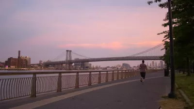
Manhattan Plans to Expand its Waterfront Renaissance
Not to be outdone by its neighboring boroughs across the East River, Manhattan is hoping to embark on an upgrade to its eastern waterfront. Tyler Silvestro has the details.

Report Reveals Proposed NYC Congestion Pricing Details
The draft proposal indicates most drivers would pay $15 to enter the Central Business District.
East River Floodgates Rising in NYC
A tour of new infrastructure designed to protect the city’s East Side from catastrophic flooding.

Maui's Vacation Rental Debate Turns Ugly
Verbal attacks, misinformation campaigns and fistfights plague a high-stakes debate to convert thousands of vacation rentals into long-term housing.

Planetizen Federal Action Tracker
A weekly monitor of how Trump’s orders and actions are impacting planners and planning in America.

In Urban Planning, AI Prompting Could be the New Design Thinking
Creativity has long been key to great urban design. What if we see AI as our new creative partner?

King County Supportive Housing Program Offers Hope for Unhoused Residents
The county is taking a ‘Housing First’ approach that prioritizes getting people into housing, then offering wraparound supportive services.

Researchers Use AI to Get Clearer Picture of US Housing
Analysts are using artificial intelligence to supercharge their research by allowing them to comb through data faster. Though these AI tools can be error prone, they save time and housing researchers are optimistic about the future.

Making Shared Micromobility More Inclusive
Cities and shared mobility system operators can do more to include people with disabilities in planning and operations, per a new report.
Urban Design for Planners 1: Software Tools
This six-course series explores essential urban design concepts using open source software and equips planners with the tools they need to participate fully in the urban design process.
Planning for Universal Design
Learn the tools for implementing Universal Design in planning regulations.
planning NEXT
Appalachian Highlands Housing Partners
Mpact (founded as Rail~Volution)
City of Camden Redevelopment Agency
City of Astoria
City of Portland
City of Laramie