


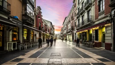
San Francisco is expanding a program of traffic light synchronization for cyclists, which is patterned after successful applications in Copenhagen, Amsterdam and Portland.
Aaron Bialick reports that the city's second green wave is now operating on 14th St. after the San Francisco Municipal Transportation Agency began work on the corridor in March. The first green wave has been operating successfully on Valencia St. since January of last year.
SF Bicycle Coalition Communications Director Kristin Smith said the organization "is very pleased to see the ‘green wave' tool used on more and more of San Francisco's key bikeways."
"It's a simple but powerful way to prioritize bike traffic and make bicycling even more convenient and comfortable," she said. "Of course, it's not just good for bike traffic - by pacing traffic to a human speed, green wave streets are safer for everyone."
"(In June), staff from the SF County Transportation Authority plans to propose 'four to six potential new Green Wave corridors along the existing San Francisco Bike Network.' The SFCTA board is expected to approve $71,000 in Prop K sales tax funds in June to plan and implement them, and the document says they could be completed between April and October of next year."
Reporting on the city's first green wave project in January of last year, Aaron Bialick notes that the Valencia St. green wave is not of the same scale as it's more famous cousin.
"The other more widely known Green Wave is Copenhagen's Nørrebrogade, the busiest bicycle street in the Western world, carrying an average of 38,000 cyclists per day with bike lanes as wide as 16 feet. There, implementation of the green wave has also improved the flow of its heavy bus traffic."
[Contributor's note: See the photos of the Green Wave signage above Valencia St. and in Copenhagen.]
Take a short ride on Nørrebrogade by viewing the video on Copenhagenize.com: Surfing the Green Wave in Copenhagen.
Thanks to SF. Streetsblog
FULL STORY: SFMTA Installs Second Green Wave for Bikes on 14th Street


Making the Golden Gate Bridge Safer for Cyclists
The Golden Gate Bridge District is looking at ways to improve safety on the bridge's narrow, windy bike and pedestrian paths.
Envisioning the 'Soft City'
Density and diversity—where boundaries between spaces and uses are lessened—create more vibrant, livable places and more functional cities.
Copenhagen Strives to Be Carbon Neutral by 2025
The Danish capital has an ambitious goal to be the world’s greenest and most bike-friendly city, and it is taking big steps to make that happen soon.

Planetizen Federal Action Tracker
A weekly monitor of how Trump’s orders and actions are impacting planners and planning in America.

Map: Where Senate Republicans Want to Sell Your Public Lands
For public land advocates, the Senate Republicans’ proposal to sell millions of acres of public land in the West is “the biggest fight of their careers.”

Restaurant Patios Were a Pandemic Win — Why Were They so Hard to Keep?
Social distancing requirements and changes in travel patterns prompted cities to pilot new uses for street and sidewalk space. Then it got complicated.

Platform Pilsner: Vancouver Transit Agency Releases... a Beer?
TransLink will receive a portion of every sale of the four-pack.

Toronto Weighs Cheaper Transit, Parking Hikes for Major Events
Special event rates would take effect during large festivals, sports games and concerts to ‘discourage driving, manage congestion and free up space for transit.”

Berlin to Consider Car-Free Zone Larger Than Manhattan
The area bound by the 22-mile Ringbahn would still allow 12 uses of a private automobile per year per person, and several other exemptions.
Urban Design for Planners 1: Software Tools
This six-course series explores essential urban design concepts using open source software and equips planners with the tools they need to participate fully in the urban design process.
Planning for Universal Design
Learn the tools for implementing Universal Design in planning regulations.
Heyer Gruel & Associates PA
JM Goldson LLC
Custer County Colorado
City of Camden Redevelopment Agency
City of Astoria
Transportation Research & Education Center (TREC) at Portland State University
Camden Redevelopment Agency
City of Claremont
Municipality of Princeton (NJ)