


California wants the region to work together to deal with the impacts of climate change.
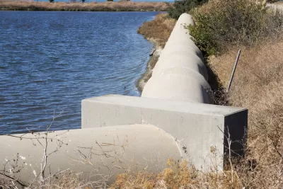
Over the next three years, state officials will draft a plan to help the Bay Area prepare its communities and infrastructure for the risks of sea-level rise to local. A 2012 study found that by the year 2100, daily tides could reach up to 66 inches higher than today.
The San Francisco Bay Conservation and Development Commission, a state agency, will partner with Caltrans and the Metropolitan Transportation Commission on the plan, recommending that local governments also collaborate on climate change adaptation efforts.
Work will begin with the completion of "vulnerability assessments" for areas along the shoreline, focusing particularly on major roads, rail corridors, and "communities with characteristics that make them more vulnerable to sea level rise," according to the San Francisco Chronicle.
The Commission originally agreed to pursue an adaptation strategy four months ago.
FULL STORY: State agency to draw up plan for sea level rise in Bay Area

Bay Area's First Climate Adaptation Project Could Be a North Bay Highway
State Route 37 is a vital highway connecting four North Bay counties plagued by two unrelated problems: chronic flooding during high tides and traffic congestion. Fixing the problem will set a precedent for Bay Area climate adaptation.
How Cities Can Support Climate Adaptation
In the face of federal cuts to climate resilience funding, a panel at ULI’s Resilience Summit offered suggestions for maintaining managed retreat and other climate adaptation programs.

How US Cities Can Prepare for Climate Disasters
Resilience, encompassing infrastructure, governance, economic strength, and social cohesion, is critical for cities to mitigate rising climate risks like flooding, wildfires, and heat, ensuring long-term recovery and adaptability.

Planetizen Federal Action Tracker
A weekly monitor of how Trump’s orders and actions are impacting planners and planning in America.

Congressman Proposes Bill to Rename DC Metro “Trump Train”
The Make Autorail Great Again Act would withhold federal funding to the system until the Washington Metropolitan Area Transit Authority (WMATA), rebrands as the Washington Metropolitan Authority for Greater Access (WMAGA).

The Simple Legislative Tool Transforming Vacant Downtowns
In California, Michigan and Georgia, an easy win is bringing dollars — and delight — back to city centers.

The Small South Asian Republic Going all in on EVs
Thanks to one simple policy change less than five years ago, 65% of new cars in this Himalayan country are now electric.

DC Backpedals on Bike Lane Protection, Swaps Barriers for Paint
Citing aesthetic concerns, the city is removing the concrete barriers and flexposts that once separated Arizona Avenue cyclists from motor vehicles.

In These Cities, Most New Housing is Under 441 Square Feet
With loosened restrictions on “micro-housing,” tiny units now make up as much as 66% of newly constructed housing.
Urban Design for Planners 1: Software Tools
This six-course series explores essential urban design concepts using open source software and equips planners with the tools they need to participate fully in the urban design process.
Planning for Universal Design
Learn the tools for implementing Universal Design in planning regulations.
Smith Gee Studio
City of Charlotte
City of Camden Redevelopment Agency
City of Astoria
Transportation Research & Education Center (TREC) at Portland State University
US High Speed Rail Association
City of Camden Redevelopment Agency
Municipality of Princeton (NJ)