


The U.S. Department of Transit has released its first ever National Transit Map.
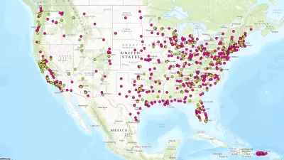
"The U.S. Department of Transportation’s Bureau of Transportation Statistics (BTS) today released National Transit Map data, a geospatial database containing the information submitted by almost 200 transit agencies that provides open, machine-readable data about their stops, routes, and schedules," according to a press release from BTS.
The national, openly available map of fixed-guideway and fixed-route transit service in America will allow the U.S. Department of Transportation (DOT) to demonstrate the importance and role of transit in American society and to identify and address gaps in access to public transportation. It will also support research, planning and analysis on the benefits of transit, such as the economic impacts of transit on a community’s economic development, or on reducing poverty in low-income neighborhoods.
Transportation Secretary Anthony Foxx also penned a blog post for the occasion, including a call for action to fill in some of the gaps in the map.
We have work still to do to ensure that each transit agency has this kind of data so we can make sure the Map represents all transit service. We're taking an iterative approach to building this important asset, and we are looking forward to demonstrating progress in future releases.
The idea for the National Transit Map was announced back in March, and between that time and now, the team behind the map gathered data from 270 transit agencies to map "nearky [sic] 400,000 stops and stations on nearly 10,000 routes."
FULL STORY: National Transit Map Data


U.S. DOT Making a National Transit Map
Transportation Secretary Antony Foxx called on local transit agencies earlier this month to share data to be used in building a comprehensive map of the nation's transit lines.
Transportation Secretary Foxx Wants to Go Out With a Bang
Governing profiles Transportation Secretary Anthony Foxx's ambitious goals to change the way the country thinks about transportation.
Financing of Hudson River Rail Tunnels in Peril
A funding agreement between New York, New Jersey, and the U.S. DOT for one of the most important rail projects in the nation is in danger of collapsing because of the way the two states are financing their share of the $12.9 billion cost.

Planetizen Federal Action Tracker
A weekly monitor of how Trump’s orders and actions are impacting planners and planning in America.

Congressman Proposes Bill to Rename DC Metro “Trump Train”
The Make Autorail Great Again Act would withhold federal funding to the system until the Washington Metropolitan Area Transit Authority (WMATA), rebrands as the Washington Metropolitan Authority for Greater Access (WMAGA).

The Simple Legislative Tool Transforming Vacant Downtowns
In California, Michigan and Georgia, an easy win is bringing dollars — and delight — back to city centers.

Demise of Entertainment Industry Mirrors Demise of Housing in LA
Making movies has a lot in common with developing real estate: producers = developers; screenwriters = architects; directors = general contractors. The similarities are more than trivial. Both industries are now hurting in L.A.

How Public Spaces Exclude Teen Girls
Adolescent girls face unique challenges and concerns when navigating public spaces. We can design cities with their needs in mind.

Proposed Ohio Budget Preserves Housing Trust Fund
The Senate-approved budget also creates two new programs aimed at encouraging housing construction.
Urban Design for Planners 1: Software Tools
This six-course series explores essential urban design concepts using open source software and equips planners with the tools they need to participate fully in the urban design process.
Planning for Universal Design
Learn the tools for implementing Universal Design in planning regulations.
Smith Gee Studio
City of Charlotte
City of Camden Redevelopment Agency
City of Astoria
Transportation Research & Education Center (TREC) at Portland State University
US High Speed Rail Association
City of Camden Redevelopment Agency
Municipality of Princeton (NJ)