


When Frank Gehry's involvement in the L.A. River restoration was announced in August 2015, the firm had already been conducting research on the project for nearly a year. For some time after that, details were scant and speculation abounded.
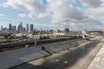
In a presentation at VerdeXchange in Los Angeles last month, Tensho Takemori of Gerhy Partners delved into the details of the firm’s approach to the river's hydrology—beginning with the very basics.
"We started by asking our client [the LA River Revitalization Corporation] for a 3D model of the Los Angeles River,” Takemori says. “We found out something interesting: there wasn’t one."
And though a number of plans and studies have taken the river as an object over the years, Takemori says none have crossed jurisdictional lines to paint a picture of the river as a whole.
So Gehry Partners embarked on an extensive research period to start filling in the gaps. The team is now compiling a 3D model of about 70 percent of the river’s 51-mile length (the portion that has a concrete bottom), and has identified a set of data topics to evaluate. Ultimately, GIS data on water flow, public health, greenhouse gas emissions, the arts, and more will be able to be overlaid with the model.
"We’re trying to formulate a single comprehensive database that everybody who works on the river can use," Takemori explains.
Additionally, by determining correlations among the various sets of data, the firm hopes to build a case for state and federal agencies that investment in the river can yield returns in a number of social, environmental, and economic areas.
That multi-faceted approach was echoed in VerdeXchange's keynote address by LA Mayor Eric Garcetti, who offered a vision of the river that was by turns personal, historical, and practical. On the following panel with Takemori, veteran environmentalist Joe Edmiston and L.A. Deputy Mayor Barbara Romero also provided insights into the many ecological and community-based impacts the river restoration could have.
VerdeXchange’s "A River Runs Through It" session, which included both the keynote and the panel, is reprinted in The Planning Report.
FULL STORY: VX2016 LA River Plenary Featured: Mayor, Gehry Partners, Edmiston, Romero

Gehry's Plans for Los Angeles River Restoration Gaining Clarity
Details are emerging in the controversial effort by Gehry Partners, LLP to plan a new vision for the Los Angeles River. So far, however, Gehry Partners seems to have been listening more than plotting or drawing.
A New Master Plan for the Los Angeles River
The L.A. County Board of Supervisors voted to approved a new master plan for the L.A. River—the “Reimagined River.”
A Comment for the L.A. River Master Plan
Five themes proposed to achieve justice and sustainability for the Los Angeles River and its surrounding communities.

Pennsylvania Mall Conversion Bill Passes House
If passed, the bill would promote the adaptive reuse of defunct commercial buildings.

Planning for Accessibility: Proximity is More Important than Mobility
Accessibility-based planning minimizes the distance that people must travel to reach desired services and activities. Measured this way, increased density can provide more total benefits than increased speeds.

World's Largest Wildlife Overpass In the Works in Los Angeles County
Caltrans will soon close half of the 101 Freeway in order to continue construction of the Wallis Annenberg Wildlife Crossing near Agoura Hills in Los Angeles County.

Eviction Looms for Low-Income Tenants as Rent Debt Rises
Nonprofit housing operators across the country face almost $10 billion in rent debt.

Brightline West Breaks Ground
The high-speed rail line will link Las Vegas and the Los Angeles area.

Colorado Bans No-Fault Evictions
In most cases, landlords must provide a just cause for evicting tenants.
City of Costa Mesa
Licking County
Barrett Planning Group LLC
HUD's Office of Policy Development and Research
Mpact Transit + Community
HUD's Office of Policy Development and Research
Tufts University, Department of Urban and Environmental Policy & Planning
City of Universal City TX
ULI Northwest Arkansas
Urban Design for Planners 1: Software Tools
This six-course series explores essential urban design concepts using open source software and equips planners with the tools they need to participate fully in the urban design process.
Planning for Universal Design
Learn the tools for implementing Universal Design in planning regulations.