


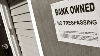
The Innovation Team in Mobile shows that sometimes innovation can be delivered through commonplace technology.
J.B. Wogan reports on the surprisingly low-cost solution developed in Mobile, Alabama: using the image and mapping capabilities of the popular social media app Instagram to make an initial survey of the city's blighted properties.
After receiving a $1.65 million grant last December as one of the Bloomberg Philanthropies "Innovation Teams," Joan Dunlap and her team in Mobile was able to implement Instagram at no cost to fill a badly needed survey need to begin to document the location and scale of the city's blighted properties:
"The city could create an account and send code enforcement officers to take photos of blighted properties. The app would automatically document the general location of the photo and its mapping function allowed the mayor’s team to see where the biggest concentrations of blight were. Unlike the 311 call data, it was easily accessible from any workers’ computer and could be updated as officers found more properties."
In effect, Instagram helped kick start the effort by gathering data that the city previously could not access. After the initial, Instagram-enabled survey, the Mobile's Geographic Information Systems department provided "a better app that allows [code enforcement] to pinpoint the exact locations of each property." In the end, the city was able to collect data and begin to build a strategy for mitigating 1,256 blighted properties, according to Wogan.
FULL STORY: How Mobile, Alabama, Used Instagram to Address Blight

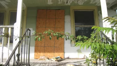
In Mobile, an Institutional Revamp to Tackle Blight
Mobile, Alabama, has changed the way it deals with blight, and the results have been substantial.
12 Cities Awarded 'Innovation Delivery Team' Grants from Bloomberg Philanthropies
After announcing a first round of grants in August, Bloomberg Philanthropies expanded its $45 million innovation teams program to 12 cities in the United States and two abroad.
From Vacant Property to Affordable Housing Development
The city of St. Petersburg provides a model for transforming blight to a blessing.

Planetizen Federal Action Tracker
A weekly monitor of how Trump’s orders and actions are impacting planners and planning in America.

Congressman Proposes Bill to Rename DC Metro “Trump Train”
The Make Autorail Great Again Act would withhold federal funding to the system until the Washington Metropolitan Area Transit Authority (WMATA), rebrands as the Washington Metropolitan Authority for Greater Access (WMAGA).

The Simple Legislative Tool Transforming Vacant Downtowns
In California, Michigan and Georgia, an easy win is bringing dollars — and delight — back to city centers.

The States Losing Rural Delivery Rooms at an Alarming Pace
In some states, as few as 9% of rural hospitals still deliver babies. As a result, rising pre-term births, no adequate pre-term care and harrowing close calls are a growing reality.

The Small South Asian Republic Going all in on EVs
Thanks to one simple policy change less than five years ago, 65% of new cars in this Himalayan country are now electric.

DC Backpedals on Bike Lane Protection, Swaps Barriers for Paint
Citing aesthetic concerns, the city is removing the concrete barriers and flexposts that once separated Arizona Avenue cyclists from motor vehicles.
Urban Design for Planners 1: Software Tools
This six-course series explores essential urban design concepts using open source software and equips planners with the tools they need to participate fully in the urban design process.
Planning for Universal Design
Learn the tools for implementing Universal Design in planning regulations.
Smith Gee Studio
City of Charlotte
City of Camden Redevelopment Agency
City of Astoria
Transportation Research & Education Center (TREC) at Portland State University
US High Speed Rail Association
City of Camden Redevelopment Agency
Municipality of Princeton (NJ)