


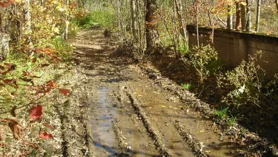
Act 178, approved by Vermont in 2006, required that all ancient roads be catalogued by July 1, 2015 to be included in the state map. The exploration of old roads leading up to that deadline makes a compelling story.
Geoff Manaugh reports on a problem of legal history unique to Vermont and the exploration it has inspired.
First the root of the problem:
"In other states, a road that goes unused for a reasonable period of time is legally discontinued; in Vermont, any road that was ever officially entered into a town’s record books remains legally recognized, indefinitely. It doesn’t matter if the road has not been travelled in two hundred years, or if it was never travelled at all, or if it was merely surveyed and never actually built. Any ancient road that exists on paper—unless it has been explicitly discontinued—is considered a public highway in the eye of the law."
Then the response:
"In 2006, prompted by a groundswell of complaints from Vermonters unable to obtain title insurance for their properties or to keep snowmobilers out of their flowerbeds, the state government passed Act 178, which aimed to brush away the infrastructural cobwebs. The act gave the towns until February of 2010 to identify and map any potential ancient roads within their borders; these would then be reviewed by the state and added to Vermont’s official highway map over the next five years. Any ancient road not added to the state map by July 1, 2015, would be considered discontinued."
Act 178 prompted a wave of amateur research on the state's history. The article explores the research findings and methodology of one particularly zealous contributor to that effort, Norman Arsenault.
FULL STORY: Where the Roads Have No Name

Interactive Map Documents Road Quality
A new interactive map shows wear-and-tear on city roads, color-coding where work needs to be done and where smooth rides can be found.

Interactive Map Reveals America's “Shade Deserts”
Launched by UCLA and American Forests to combat heat-related deaths, the tool maps the shade infrastructure for over 360 U.S. cities.
Texas Infrastructure Gets a ‘C’
The American Society of Civil Engineers rates states in 16 categories related to transportation, water, waste management, parks, and more.

Planetizen Federal Action Tracker
A weekly monitor of how Trump’s orders and actions are impacting planners and planning in America.

Congressman Proposes Bill to Rename DC Metro “Trump Train”
The Make Autorail Great Again Act would withhold federal funding to the system until the Washington Metropolitan Area Transit Authority (WMATA), rebrands as the Washington Metropolitan Authority for Greater Access (WMAGA).

The Simple Legislative Tool Transforming Vacant Downtowns
In California, Michigan and Georgia, an easy win is bringing dollars — and delight — back to city centers.

DC Backpedals on Bike Lane Protection, Swaps Barriers for Paint
Citing aesthetic concerns, the city is removing the concrete barriers and flexposts that once separated Arizona Avenue cyclists from motor vehicles.

In These Cities, Most New Housing is Under 441 Square Feet
With loosened restrictions on “micro-housing,” tiny units now make up as much as 66% of newly constructed housing.

Albuquerque’s Microtransit: A Planner’s Answer to Food Access Gaps
New microtransit vans in Albuquerque aim to close food access gaps by linking low-income areas to grocery stores, cutting travel times by 30 percent and offering planners a scalable model for equity-focused transit.
Urban Design for Planners 1: Software Tools
This six-course series explores essential urban design concepts using open source software and equips planners with the tools they need to participate fully in the urban design process.
Planning for Universal Design
Learn the tools for implementing Universal Design in planning regulations.
Smith Gee Studio
City of Charlotte
City of Camden Redevelopment Agency
City of Astoria
Transportation Research & Education Center (TREC) at Portland State University
US High Speed Rail Association
City of Camden Redevelopment Agency
Municipality of Princeton (NJ)