


The water level in Lake Mead dropped to an all-time low at the end of April, falling below 1080 feet above sea level for the first time in 78 years.
An article by Alexandria Icenhower and Shawn Dar explains that the recent record low levels achieved by Lake Mead amidst the ongoing drought affecting the Western United States "will continue to have consequences for states like Arizona, California, and Nevada that draw their water supply from Lake Mead."
To put the record in perspective, Icenhower and Dar share insights into a new video by Brookings Nonresident Senior Fellow Pat Mulroy, who is also the former general manager of the Southern Nevada Water Authority. Among the facts explained in the video, also embedded below, are the critical stats on how much water the Lake Mead holds at capacity, how much its holding now, the preparation the Southern Nevada Water Authority has already taken to prepare for the worst possible drought scenarios, and the culture change that will still be required to weather the ongoing, historic drought.
In a separate article, John M. Glionna provides more details on the record setting low levels of Lake Mead.
FULL STORY: 5 facts you need to know about Lake Mead’s water crisis


Colorado River Water Crisis Deepens
The states that rely on the Colorado’s water must make drastic cuts in water usage to maintain use of the West’s most important—and most threatened—water source.
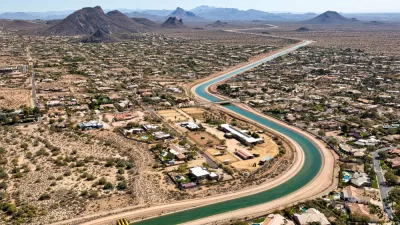
Booming Arizona Must Confront its Water Problem
Even as more people and companies flock to the state for its climate and economic opportunities, Arizona's water supplies are facing historic shortages.
Arizona Governor Pledges $1 Billion to Water Infrastructure
The billion-dollar investment in the state's water supplies sounds good on paper, but lawmakers must also distribute funding effectively to mitigate the state's urgent water shortage.

Planetizen Federal Action Tracker
A weekly monitor of how Trump’s orders and actions are impacting planners and planning in America.

Congressman Proposes Bill to Rename DC Metro “Trump Train”
The Make Autorail Great Again Act would withhold federal funding to the system until the Washington Metropolitan Area Transit Authority (WMATA), rebrands as the Washington Metropolitan Authority for Greater Access (WMAGA).

The Simple Legislative Tool Transforming Vacant Downtowns
In California, Michigan and Georgia, an easy win is bringing dollars — and delight — back to city centers.

DC Backpedals on Bike Lane Protection, Swaps Barriers for Paint
Citing aesthetic concerns, the city is removing the concrete barriers and flexposts that once separated Arizona Avenue cyclists from motor vehicles.

In These Cities, Most New Housing is Under 441 Square Feet
With loosened restrictions on “micro-housing,” tiny units now make up as much as 66% of newly constructed housing.

Albuquerque’s Microtransit: A Planner’s Answer to Food Access Gaps
New microtransit vans in Albuquerque aim to close food access gaps by linking low-income areas to grocery stores, cutting travel times by 30 percent and offering planners a scalable model for equity-focused transit.
Urban Design for Planners 1: Software Tools
This six-course series explores essential urban design concepts using open source software and equips planners with the tools they need to participate fully in the urban design process.
Planning for Universal Design
Learn the tools for implementing Universal Design in planning regulations.
Smith Gee Studio
City of Charlotte
City of Camden Redevelopment Agency
City of Astoria
Transportation Research & Education Center (TREC) at Portland State University
US High Speed Rail Association
City of Camden Redevelopment Agency
Municipality of Princeton (NJ)