


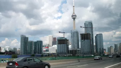
A recently released report makes the case for removing, in part or in full, an elevated span of roadway along the Toronto Waterfront.
David Rider reports on the recently released environmental assessment (EA) released by Waterfront Toronto, a public organization tasked with revitalizing Toronto waterfront, that recommends removing part of all of the Gardiner Expressway.
The EA considers options for full or partial (called a "hybrid" plan by the report) removal of the elevated span. Full removal would entail "[r]emoving the entire 2.4 kilometre expressway east of Jarvis St., and replacing the stretch to the Don Valley Parkway with an eight-lane, street-level boulevard," according to Rider. The hybrid plan would "[leave] the elevated Gardiner in place between Jarvis and the Don River, and replace the ramp between the Don and Logan Ave. with a six-lane boulevard."
Rider lists out the benefits of each plan, as stated in the EA, and also notes that the cost of simply maintaining the span as it is would require $864 million over the next 100 years. The article includes "swipe" frames of renderings used to compare each of the two options.
FULL STORY: All or part of the eastern Gardiner should be removed, study says

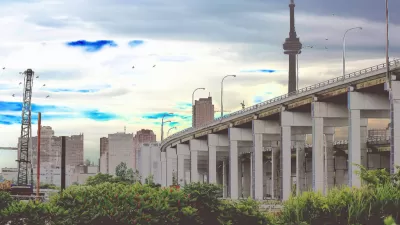
Toronto City Council Decides to Rebuild Gardiner East Expressway
Coulda, woulda, shoulda. The Toronto City Council sided with Mayor John Tory this week to rebuild an elevated freeway in downtown rather than tearing it down.
Are Movie Studios 'Highest and Best Use' During a Housing Affordability Crisis?
Toronto's answer to the question posed in the headline is, "yes." One columnist wonders if the city can do more to balance its priorities.
Proposed Toronto Highways Raise Environmental Concerns
Opponents of two new planned highways in greater Toronto argue the construction of new roads is 'short-sighted at best' and would threaten the region's greenbelt areas.

Trump Administration Could Effectively End Housing Voucher Program
Federal officials are eyeing major cuts to the Section 8 program that helps millions of low-income households pay rent.

Planetizen Federal Action Tracker
A weekly monitor of how Trump’s orders and actions are impacting planners and planning in America.

Canada vs. Kamala: Whose Liberal Housing Platform Comes Out on Top?
As Canada votes for a new Prime Minister, what can America learn from the leading liberal candidate of its neighbor to the north?

Washington State’s Parking Reform Law Could Unlock ‘Countless’ Acres for New Housing
A law that limits how much parking cities can require for residential amd commercial developments could lead to a construction boom.

Wildlife Rebounds After the Eaton Fire
Following the devastation of the Eaton Fire, the return of wildlife and the regrowth of native plants are offering powerful signs of resilience and renewal.

LA to Replace Inglewood Light Rail Project With Bus Shuttles
LA Metro says the change is in response to community engagement and that the new design will be ready before the 2028 Olympic Games.
Urban Design for Planners 1: Software Tools
This six-course series explores essential urban design concepts using open source software and equips planners with the tools they need to participate fully in the urban design process.
Planning for Universal Design
Learn the tools for implementing Universal Design in planning regulations.
Central Transportation Planning Staff/Boston Region MPO
Heyer Gruel & Associates PA
Institute for Housing and Urban Development Studies (IHS)
City of Grandview
Harvard GSD Executive Education
Regional Transportation Commission of Southern Nevada
Toledo-Lucas County Plan Commissions