


The most transit-oriented metro areas often have lower levels of traffic congestion than one might expect based on their size.

A few weeks ago, Wendell Cox wrote a blog post asserting that the most dense metros tend to have the highest levels of congestion. Assuming for the sake of argument that his methodology for measuring congestion makes sense, it does not necessarily follow that sprawl equals low congestion, or that transit-oriented development equals high congestion.
Cox focuses on metrowide density. But there are different kinds of density; some regions, such as Los Angeles, have high regionwide density but so-so transit systems, car-oriented street design, and a not-too-dense central city. Others, such as Boston, combine a very dense, transit-oriented core with not-so-dense suburbs. Regions in the first group tend to have low transit ridership, thus effectively combining density and sprawl. In addition, large regions are likely to have higher congestion than small regions, even leaving aside density.
So I thought I would take a look at Cox's data and ask a slightly different question: do transit-oriented places have more congestion than one might expect for their size, or less?
Exhibit A is New York City: the region with the highest transit ridership in the United States. Since New York is the largest region in the nation, one might expect it to have high levels of congestion. But according to Cox, New York is only fourth in congestion. Thus, it appears that a highly dense core, when combined with less-dense suburbs, will have levels of congestion lower than one might expect based on population.
Five other large regions (Philadelphia, Chicago, Boston, San Francisco, and Washington) have highly transit-oriented central cities: that is, cities where over 25 percent of residents use transit to get to work. All of these cities have fairly high central-core density; all but one (Washington) that is, over 10,000 people per square mile within the city limits, and Washington is pretty close to the 10,000/square mile mark.* In fact, five of these cities (all but Washington) are the five most dense principal cities (that is, largest city in their metropolitan area) in the United States.
Philadelphia has the fifth highest regional population, but only the thirteenth highest level of congestion. Thus, Philadelphia clearly outperforms its population in addressing traffic congestion—that is, it has less congestion than one might expect from its size.
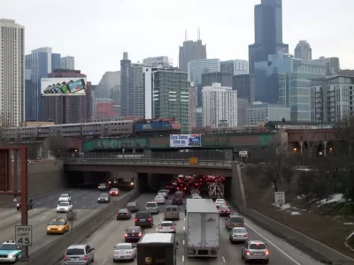
Chicago has the third highest regional population, but only the 12th highest level of congestion. Thus, Chicago again outperforms expectations.
On the other hand, two other transit-oriented regions do not outperform. Boston has the tenth highest population but the eighth highest level of congestion, and San Francisco has the eleventh highest population but the third highest level of congestion. (Washington ranks no. 7 in both).
On balance, transit-oriented regions do not seem to have more traffic congestion, controlling for size, than the nation as a whole.
*Washington has 61 square miles and 602,000 people, according to the 2010 Census.


Large Cities Were Already Losing Population. Then Came the Coronavirus.
"Cities of all sizes may soon look less alluring, if drastic drops in income, sales and tourism tax revenue leave gaping holes in budgets," according to this article, which encapsulates a popular school of thought as the pandemic rages.
How Cities and Communities Can Rebound From the Pandemic
An interview with Michael Berkowitz, former executive director of 100 Resilient Cities, finds a path to the light at the end of the tunnel.
Keys to Safely Reopening Cities After the Pandemic
Cities have survived terrible infectious diseases before, because the power of concentrated human and economic activity is just so strong. When it’s time to reopen U.S. cities, a few key actions will ensure the future safety and health of all.

Planetizen Federal Action Tracker
A weekly monitor of how Trump’s orders and actions are impacting planners and planning in America.

Map: Where Senate Republicans Want to Sell Your Public Lands
For public land advocates, the Senate Republicans’ proposal to sell millions of acres of public land in the West is “the biggest fight of their careers.”

Restaurant Patios Were a Pandemic Win — Why Were They so Hard to Keep?
Social distancing requirements and changes in travel patterns prompted cities to pilot new uses for street and sidewalk space. Then it got complicated.

Platform Pilsner: Vancouver Transit Agency Releases... a Beer?
TransLink will receive a portion of every sale of the four-pack.

Toronto Weighs Cheaper Transit, Parking Hikes for Major Events
Special event rates would take effect during large festivals, sports games and concerts to ‘discourage driving, manage congestion and free up space for transit.”

Berlin to Consider Car-Free Zone Larger Than Manhattan
The area bound by the 22-mile Ringbahn would still allow 12 uses of a private automobile per year per person, and several other exemptions.
Urban Design for Planners 1: Software Tools
This six-course series explores essential urban design concepts using open source software and equips planners with the tools they need to participate fully in the urban design process.
Planning for Universal Design
Learn the tools for implementing Universal Design in planning regulations.
Heyer Gruel & Associates PA
JM Goldson LLC
Custer County Colorado
City of Camden Redevelopment Agency
City of Astoria
Transportation Research & Education Center (TREC) at Portland State University
Camden Redevelopment Agency
City of Claremont
Municipality of Princeton (NJ)