


Seth Kadish says he was born with an innate sense of direction. As such, he appreciates street grids oriented to cardinal directions. The phenomena interested him enough to create a graphic that visualizes the orientation of 12 urban areas.
“If you’re like me, and you use the Sun to navigate, you probably appreciate cities with gridded street plans that are oriented in the cardinal directions,” writes Seth Kadish in introducing a cool visualization exercise that produced a graphic representation of the orientation of street grids for 12 metropolitan areas around the United States.
Like many of us, Kadish has noticed how the orientation of each city is as unique as the city itself: “…not all urban planners settled on such a simple layout for road networks. For some developers, topography or water may have gotten in the way. Others may not have appreciated the efficiency of the grid.” To examine the differences in orientation, Kadish created a visualization that compares the relative degree to which city streets are gridded.
Here are a few of Kadish’s observations from the visualization; “The plots reveal some stark trends. Most of the counties considered do conform to a grid pattern. This is particularly pronounced with Chicago, even though much of Cook County is suburban. Denver, Jacksonville, Houston, and Washington, D.C., also have dominant grid patterns that are oriented in the cardinal directions. While Philadelphia and New York are primarily gridded, their orientations are slightly skewed from the traditional N-E-S-W bearings.”
FULL STORY: On and Off the Street Grid: Relative Distributions of Road Orientations
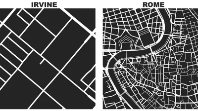
Friday Eye Candy: Comparing a Square Mile of the World's Famous Cities
Street networks and city blocks, reduced to their fundamental attributes, reveal the vast differences between cities.

The Dots of Connectivity and Broken Cultural Links
Connectivity is not just a question of geometry, according to this article by Fanis Grammenos. It's critical to consider what people connect for and how.

A 'Cul-De-Tax' for the Cul-De-Sac?
A recent study studying the contemporary planning profession's rejection of the cul-de-sac includes a proposal to create more economic disincentives for inefficient street grid patterns.

Depopulation Patterns Get Weird
A recent ranking of “declining” cities heavily features some of the most expensive cities in the country — including New York City and a half-dozen in the San Francisco Bay Area.

California Exodus: Population Drops Below 39 Million
Never mind the 40 million that demographers predicted the Golden State would reach by 2018. The state's population dipped below 39 million to 38.965 million last July, according to Census data released in March, the lowest since 2015.

Chicago to Turn High-Rise Offices into Housing
Four commercial buildings in the Chicago Loop have been approved for redevelopment into housing in a bid to revitalize the city’s downtown post-pandemic.

How California Transit Agencies are Addressing Rider Harassment
Safety and harassment are commonly cited reasons passengers, particularly women and girls, avoid public transit.

Significant Investments Needed to Protect LA County Residents From Climate Hazards
A new study estimates that LA County must invest billions of dollars before 2040 to protect residents from extreme heat, increasing precipitation, worsening wildfires, rising sea levels, and climate-induced public health threats.

Federal Rule Raises Cost for Oil and Gas Extraction on Public Lands
An update to federal regulations raises minimum bonding to limit orphaned wells and ensure cleanup costs are covered — but it still may not be enough to mitigate the damages caused by oil and gas drilling.
City of Costa Mesa
Licking County
Barrett Planning Group LLC
HUD's Office of Policy Development and Research
Mpact Transit + Community
HUD's Office of Policy Development and Research
City of Universal City TX
ULI Northwest Arkansas
City of Laramie, Wyoming
Urban Design for Planners 1: Software Tools
This six-course series explores essential urban design concepts using open source software and equips planners with the tools they need to participate fully in the urban design process.
Planning for Universal Design
Learn the tools for implementing Universal Design in planning regulations.