


Planners must anticipate how people would respond to new options, such as better walking, cycling and public transit services. This requires imagination.

Once upon a time two competing shoe salesmen together visited an isolated community. After investigating the area one sent a telegram back to his office which read, “I’m returning tomorrow. Nobody here wears shoes!” while the other sent a telegram which read, “Send more product. Everybody here needs shoes!”
This illustrates the concept of latent demand, which refers to new goods and services that people would choose if they were available. The first saleman couldn't imagine currently barefooted people wearing shoes, the second saw opportunity.
This is an important factor to consider in planning; our job often entails anticipating how people would respond to new options and incentives, which can be difficult because it requires imagining a world that is different from what currently exists.
A good example of this is a recent column by the Georgia Public Policy Foundation (GPPF) opposing complete streets on the grounds that they harm commuters. Their arguments assume that Georgia's high automobile mode share is unchangeable and desirable. They cannot image a more multi-modal transportation system.
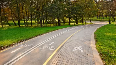
Yet, there is good evidence of significant latent demand for walking, cycling and public transport. A detailed study, Infrastructure, Programs, And Policies To Increase Bicycling: An International Review, and the U.S. Federal Highway Admimistration’s Report to the U.S. Congress on the Outcomes of the Nonmotorized Transportation Pilot Program, indicate that walking and cycling improvements often significantly increase use of these modes.
Serving this demand can benefit everybody. Walking, cycling and public transit play unique and important roles in an equitable and efficient transport system. In a typical community 20-40% of the population cannot or should not drive due to age, ability or income, and many trips are most efficiently made by alternative modes. It is unfair if non-drivers are not given a share of transportation infrastructure resources, and it is inefficient if parents are forced to drive children to local destinations due to inadequate pedestrian and cycling facilities, or if lower-income households are forced to purchase more vehicles than is affordable due to inadequate transport options.
The GPPF also claims that road diets are dangerous. This is untrue. Several recent studies indicate that complete streets and road diets tend to increase traffic safety. Research by the Highway Safety Research System concludes that road diets typically reduce overall crash rates 29%.
Imagine a better world, a world in which roadway design better responds to demands for walking, cycling and public transit.
For More Information
AARP (2009), Planning Complete Streets for an Aging America, American Association for Retired Persons Public Policy Institute.
Heather Contrino and Nancy Mcguckin (2009), “Travel Demand in the Context of Growing Diversity: Considerations for Policy, Planning, and Forecasting,” TR News, Transportation Research Board (www.trb.org), September-October, pp. 4-9.
Eric Dumbaugh (2005), “Safe Streets, Livable Streets,”Journal of the American Planning Association, Vol. 71, No. 3, pp. 283-300.
HSIS (2010), Evaluation of Lane Reduction “Road Diet” Measures on Crashes Summary Report Research, Development, and Technology, Highway Safety Information System.
Todd Litman (2010), Evaluating Non-Motorized Transport Benefits and Costs, Victoria Transport Policy Institute.
Todd Litman (2012), Evaluating Complete Streets: The Value of Designing Roads For Diverse Modes, Users and Activities, Victoria Transport Policy Institute.
PPS (2012), Rightsizing Streets, Project for Public Spaces (www.pps.org); at www.pps.org/reference/rightsizing.
Carol H. Tan (2011), “Going On A Road Diet: Lane Reduction Can Increase Safety For Pedestrians, Bicyclists, And Motorists While Improving The Quality Of Life In Downtowns Across The Country,”Public Roads, U.S. Federal Highway Administration.
WSDOT (2011), Washington’s Complete Streets and Main Street Highways: Case Study Resource, Community Planning and Development, Washington State Department of Transportation.

Funding Multi-Modalism
The new Republican Party Platform wants to stop spending federal fuel tax funds on walking, cycling, and public transit. That would be unfair and inefficient.
Urban Mobility Plans Key To More Efficient and Integrated Planning
"Urban Mobility Plans – National Approaches and Local Practice," a new guidebook by the Sustainable Urban Transportation Project, describes specific policies and planning practices to maximize urban transport system efficiency.
What Would it Take to Ditch Your Car?
A conversation series from the National Trust for Historic Preservation asks what it would take for people to ditch their cars and rely solely on walking, cycling and public transportation.

Planetizen Federal Action Tracker
A weekly monitor of how Trump’s orders and actions are impacting planners and planning in America.

Congressman Proposes Bill to Rename DC Metro “Trump Train”
The Make Autorail Great Again Act would withhold federal funding to the system until the Washington Metropolitan Area Transit Authority (WMATA), rebrands as the Washington Metropolitan Authority for Greater Access (WMAGA).

The Simple Legislative Tool Transforming Vacant Downtowns
In California, Michigan and Georgia, an easy win is bringing dollars — and delight — back to city centers.

The States Losing Rural Delivery Rooms at an Alarming Pace
In some states, as few as 9% of rural hospitals still deliver babies. As a result, rising pre-term births, no adequate pre-term care and harrowing close calls are a growing reality.

The Small South Asian Republic Going all in on EVs
Thanks to one simple policy change less than five years ago, 65% of new cars in this Himalayan country are now electric.

DC Backpedals on Bike Lane Protection, Swaps Barriers for Paint
Citing aesthetic concerns, the city is removing the concrete barriers and flexposts that once separated Arizona Avenue cyclists from motor vehicles.
Urban Design for Planners 1: Software Tools
This six-course series explores essential urban design concepts using open source software and equips planners with the tools they need to participate fully in the urban design process.
Planning for Universal Design
Learn the tools for implementing Universal Design in planning regulations.
Smith Gee Studio
City of Charlotte
City of Camden Redevelopment Agency
City of Astoria
Transportation Research & Education Center (TREC) at Portland State University
US High Speed Rail Association
City of Camden Redevelopment Agency
Municipality of Princeton (NJ)