


Ronda Kaysen reports on the growing trend in transforming brownfield sites in disadvantaged communities into health centers, "in essence taking a potential source of health problems for a community and turning it into a place for health care."
In recent years, communities in Florida, Colorado, New Hampshire, Minnesota, Oregon and California have seen contaminated properties transformed into desperately needed healthcare facilities, with government tax credits and grants providing the "vital seed money" to make projects feasibile, writes Kaysen. In fact, the practice has become so widespread in Florida that an ad hoc movement led by local government officials, environmental advocates and health center developers, "have toyed with various names for the concept, like Doc in a Box, healthfields and Highway to Healthcare."
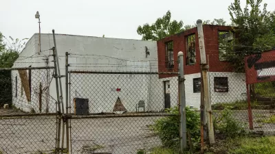
As Kaysen notes, "many of the country’s 450,000 contaminated sites, known as brownfields...are disproportionately concentrated in poor communities because contaminated sites are more difficult to redevelop if property values are depressed. Banks are often reluctant to finance construction on a property that might require a costly cleanup."
“It’s a Catch-22,” said Phyllis B. Cater, chief executive of Spectrum Health Services. “The environmental issues are significant and yet there are scarce resources for communities to do the cleanup and remediation that’s required.”
"But if the state or federal government provides the first piece of financing," says Kaysen, "other funders are more likely to fall into step."
And in places like Manchester, N.H., where a 240,000-square-foot ambulatory care facility has replaced a former Tyson meatpacking plant, such facilities can serve as the first phase of a larger redevelopment plan. “When you look at revitalizing a community, these kinds of uses tend to be the first anchors,” said Mathy Stanislaus, an assistant administrator for the Environmental Protection Agency.
FULL STORY: Health Centers Find Opportunity in Brownfields


Minnesota Seeks State Support for Office Conversions
The 30% “CUB credit” would support the conversion of buildings 15 years or older into any use that “will return that vacant area to an income-producing, habitable condition.”

Revitalizing Cities Through Soil Health, Green Spaces, and Nature-Based Remediation
Investing in soil health, urban parks, and nature-based solutions for brownfield remediation is essential for creating resilient cities, restoring ecosystems, and improving community well-being.
Map Identifies DeKalb County Brownfield Sites
The GIS tool is designed to help developers find vacant and blighted lots that could be restored for new housing or other uses.

Planetizen Federal Action Tracker
A weekly monitor of how Trump’s orders and actions are impacting planners and planning in America.

Map: Where Senate Republicans Want to Sell Your Public Lands
For public land advocates, the Senate Republicans’ proposal to sell millions of acres of public land in the West is “the biggest fight of their careers.”

Restaurant Patios Were a Pandemic Win — Why Were They so Hard to Keep?
Social distancing requirements and changes in travel patterns prompted cities to pilot new uses for street and sidewalk space. Then it got complicated.

Platform Pilsner: Vancouver Transit Agency Releases... a Beer?
TransLink will receive a portion of every sale of the four-pack.

Toronto Weighs Cheaper Transit, Parking Hikes for Major Events
Special event rates would take effect during large festivals, sports games and concerts to ‘discourage driving, manage congestion and free up space for transit.”

Berlin to Consider Car-Free Zone Larger Than Manhattan
The area bound by the 22-mile Ringbahn would still allow 12 uses of a private automobile per year per person, and several other exemptions.
Urban Design for Planners 1: Software Tools
This six-course series explores essential urban design concepts using open source software and equips planners with the tools they need to participate fully in the urban design process.
Planning for Universal Design
Learn the tools for implementing Universal Design in planning regulations.
Heyer Gruel & Associates PA
JM Goldson LLC
Custer County Colorado
City of Camden Redevelopment Agency
City of Astoria
Transportation Research & Education Center (TREC) at Portland State University
Camden Redevelopment Agency
City of Claremont
Municipality of Princeton (NJ)