


The emerging methods of urban governance, planning, design, and management made possible by technological advances in data collection, analysis, and communication promise to make our cities better, and more efficient, places to live. The Urban Systems Collaborative, a unique gathering of voices from academia and industry, is fostering a discussion about improving our cities through technology.

During the winter in Boston, school buses inevitably end up getting stuck in the snow. When that happens, the City wants to tell parents not only that students will be delayed by inclement weather but also how late their children will be. In 2011, this was a problem because there were less than half a dozen City staff available to make calls to parents in the school district. But why were parents being contacted by phone, and how did the City know how long it would take for each child to arrive? It turned out that the Boston school buses were being tracked by GPS—a detail that was instantly promising to the volunteers from Code for America who had been presented with the problem. They came back the next day with a draft app that parents could use to locate school buses on their smart phones.
This anecdote, provided by Abhi Nemani of Code for America at the most recent meeting of the Urban Systems Collaborative, provides a window into the emerging revolution of “big data”, the trail of data points generated by individuals, infrastructure, and the natural world that promises to fundamentally change our cities. With a surplus of available information, often what is needed most is for someone to connect the dots.
The Urban Systems Collaborative (USC) occupies a unique niche in the ecosystem of urban data. Coordinated by a group from academia and industry, including IBM Smarter Cities researchers Colin Harrison and Jurij Paraszczak, USC identifies itself as being “engaged in study, evaluation and modification of real-world information to reveal emerging patterns of urban behavior that are changing the ways that people live in cities and how these changes affect the planning, design, development, governance, and operation of cities.” USC met at UC Berkeley in September in their first West Coast meeting, having assembled previously in New York and Chicago. The meeting’s stated themes, which functioned more as starting points than strictly followed directives, were to map information flows for emergency management and citizen engagement, and to consider the roles of centralized and distributed approaches to operations and open data.
The keynote speech was delivered by Steven Koonin, a theoretical physicist who was recently named the Director of the Center for Urban Science and Progress (CUSP) at New York University (NYU). In his address, Koonin spoke about the ability of new information sources to help us understand the relationship between psychology, human behavior and the physical sciences—or in his words, “from sensors to sociologists.” But as Koonin noted, while big data allows for better identification of outlier values and a finer stratification of data, the flood of information raises issues about the quality of the data and who has access to it.
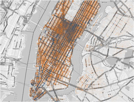
Visualization of Taxi Pick-ups (Orange) and Drop-offs (Blue) in New York City (NYU Center for Urban Science and Progress)
A series of short presentations and panel discussions followed Koonin’s keynote address. Speakers came from IBM, Esri, UC Berkeley, Stamen Design, the City of Minneapolis, Carnegie Mellon, Code for America, Fehr & Peers, Ushahidi, the City of Oakland, and Skidmore, Owings, & Merrill. To start, several perspectives were put forward on how best to understand big data. Colin Harrison suggested that systems in a city are like systems in a human body, where some processes are inherently centralized, while others are inherently diffuse. Mark Baker of Esri approached the topic of urban information through the lens of geography, saying, “big data tied to geography becomes important information.” Jerry Walters of Fehr & Peers, noted that big data gives cities greater options for faster, more efficient decision making. Jennifer Pahlka of Code for America, spoke about data in terms of public engagement, saying that “open data is about a connection between citizens and government.” Presentations were distinct, with each speaker engaging their area of interest, but in contrast to earlier USC meetings, a degree of mutual awareness and understanding between disciplines had emerged.
In addition to theoretical constructs, symposium participants also presented a variety of technical solutions already being employed to address urban problems:
- The City of Oakland has used SeeClickFix to increase citizen engagement and citizen satisfaction, through greater transparency and responsiveness.
- IBM has used algorithms to identify efficiencies in municipal water provision, both through systemic fixes (like lowering water pressure late at night to reduce leakage) and localized solutions (like finding a neighborhood where plumbers had helped residents tap into the pipes of a local laundromat).
- Fehr & Peers has produced network simulations to inform the design and operation of transportation systems from Silicon Valley to Kunming, China.
- Paul Wadell of UC Berkeley is perfecting a software tool called UrbanVision that will serve as an extension of UrbanSim with 3D visualization and help the public to more fully understand their choices for development.
- Carnegie Mellon has instituted a program called Sensor Andrew that involves campus-wide use of sensors for monitoring water, power, infrastructure, biometrics, and others systems.
- Stamen Design has produced a series of map-based infographics, including Oakland Crimespotting, which helps the public to better understand what is happening, where it is happening, and how it relates to the bigger picture.
- The City of Minneapolis is using a tool known as the Intelligent Operations Platform to integrate data streams for events, permits, incidents, and infrastructure.
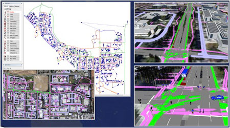
Multimodal Network Simulation in Silicon Valley (Fehr & Peers)
For some of these solutions, new data and analysis provided insight into previously unknown trends. But more frequently, technology was used to improve communication with the public. In fact, reference to the human element became one of the underlying themes of the symposium, with speakers considering the topic as it pertained to systemic change, citizen engagement, and the teaching of city science.
In his keynote address, Koonin said that innovation on its own would not be enough to affect change. The true societal levers were things like behavior, perception, and regulation. These areas, he proposed, were equally if not more important than technological advancement for altering the status quo.
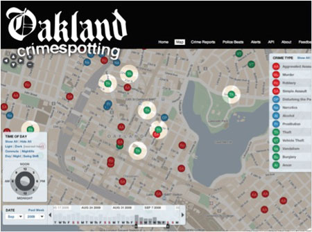
Oakland Crimespotting (Stamen Design)
Nicholas de Monchaux of UC Berkeley led a workshop tasked with proposing content for a chapter on citizen engagement in a hypothetical textbook on urban systems. Several examples were discussed, including High Speed Rail in California, the open-source Bogota taxicab database, Nextbus copyright issues, and Solar Boston environmental calculators. Among the group, there was some skepticism about whether a single chapter would be sufficient to cover the topic of citizen engagement and whether it belonged in a volume for students alongside topics like city operations. Ultimately, participants were more comfortable providing caveats than fully-formed recommendations or outlines.
- They observed that technology is most effective when it activates existing social dynamics, rather than trying to create something entirely new. As de Monchaux said, “Technology takes off when it taps into underlying behavior.”
- Participants agreed that technology is value-neutral, with the result that more technology is not necessarily better or worse.
- Technology may not fundamentally change the nature of participation, although it may act as a facilitator, lowering barriers to participation, and increasing the speed and frequency of exchange—a characteristic that could lead to positive or negative outcomes.
- And while earlier discussions had sidestepped the issue of privacy, de Monchaux confronted it head-on, noting that technology has the potential to destabilize existing urban negotiations. To use his example, when we walk outside in a city, we can see other people, and we allow them to see us. This relationship changes dramatically when we see a single Google car and six million people are able to see us in return.
The amount of available urban data will soon overwhelm the number of people trained to work with it. The McKinsey Global Institute has projected that “The United States alone faces a shortage of 140,000 to 190,000 people with analytical expertise and 1.5 million managers and analysts with the skills to understand and make decisions based on the analysis of big data.” Several academic institutions are working to meet this growing demand. NYU is bullish enough on big data that they will be supporting 50 full-time senior researchers in this area through their Center for Urban Science and Progress over the next five years, and in 2013 they will begin offering a graduate degree in Urban Science and Informatics geared toward producing graduates for public agencies, private data providers, startups, and non-governmental organizations. What is the best training for these students? If the Urban Systems Collaborative were to suggest a curriculum, would it be mathematical, spatial, design-savvy, computational, or engineering-based? Would the foundational skills taught in urban planning programs be equally prized? As Otto Doll, Chief Information Officer for the City of Minneapolis, noted at the symposium in Berkeley, big data in the abstract is not an end in itself. “The key,” he observed, “is turning information into knowledge.”

Small Cities Get Smart
A new web-based software, described as a "Google Analytics for local governments," allows smaller cities to get involved in the Gov 2.0 revolution, reports Ariel Schwartz.

How Data-Driven Research Is Shaping Sustainable Urban Development
Explore how data-driven research is revolutionizing sustainable urban development, creating smarter, greener, and more resilient cities for the future.
Hoboken's Curbs Are Going Digital
Hoboken, New Jersey, is leveraging technology to up its curb management game with a digital streetscape map that will allow real-time demand monitoring.

Planetizen Federal Action Tracker
A weekly monitor of how Trump’s orders and actions are impacting planners and planning in America.

Congressman Proposes Bill to Rename DC Metro “Trump Train”
The Make Autorail Great Again Act would withhold federal funding to the system until the Washington Metropolitan Area Transit Authority (WMATA), rebrands as the Washington Metropolitan Authority for Greater Access (WMAGA).

DARTSpace Platform Streamlines Dallas TOD Application Process
The Dallas transit agency hopes a shorter permitting timeline will boost transit-oriented development around rail stations.

Renters Now Outnumber Homeowners in Over 200 US Suburbs
High housing costs in city centers and the new-found flexibility offered by remote work are pushing more renters to suburban areas.

The Tiny, Adorable $7,000 Car Turning Japan Onto EVs
The single seat Mibot charges from a regular plug as quickly as an iPad, and is about half the price of an average EV.

Supreme Court Ruling in Pipeline Case Guts Federal Environmental Law
The decision limits the scope of a federal law that mandates extensive environmental impact reviews of energy, infrastructure, and transportation projects.
Urban Design for Planners 1: Software Tools
This six-course series explores essential urban design concepts using open source software and equips planners with the tools they need to participate fully in the urban design process.
Planning for Universal Design
Learn the tools for implementing Universal Design in planning regulations.
Municipality of Princeton
Roanoke Valley-Alleghany Regional Commission
City of Mt Shasta
City of Camden Redevelopment Agency
City of Astoria
Transportation Research & Education Center (TREC) at Portland State University
US High Speed Rail Association
City of Camden Redevelopment Agency
Municipality of Princeton (NJ)