


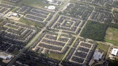
Charlie Gardner parses the data on mean commuting times recently released as part of the 2010 ACS estimates for metropolitan statistical areas, and wonders what the maximum mean travel time suggests for the urban form of America's cities.
When comparing the mean commuting times among America's large metro areas, something funny appears. "Although population is strongly correlated with commuting time,
particularly when all metro areas over population one million are
included in the sample, the differences are surprisingly small," notes Gardner. For example, "Orlando, with an urbanized area of only 600 square miles, has a mean
commute just twelve seconds shorter than Dallas, which covers 1,780
square miles, although both cities have comparable densities, employment
centralization and highway miles per capita."
So is there an inherent limit to the potential extent to which development will sprawl into the fringes of a metropolitan area based on a maximum mean commute time of around 30 minutes? Gardner seems to think so and describes how development in, and around Houston, might be shaped by such forces.
"This theory doesn't imply that outwards expansion will come to a
screeching halt once some magical distance from the center is reached," writes Gardner,
"but that the balance of new construction will attempt to shift to the
core as commutes from fringe areas begin to significantly exceed 30
minutes."
Thanks to Daniel Lippman
FULL STORY: Commutes, Tradeoffs and the Limits of Urban Growth


Promoting Infill Development for a Denser Houston
An advocacy group is calling for ‘sustainable, vertical’ mixed-use urbanism in the famously sprawling city.
Houston Area's Center of Gravity Shifts Outside the Loop
The population center of Harris County is now outside central Houston, a shift that occurred over the last two decades as the region's suburbs blossomed.

Can Houston Rein In Its Famous Sprawl?
The city's unabated growth has made it a bustling hub of industry and commerce, but can it sustain its unmitigated outward sprawl?

Planetizen Federal Action Tracker
A weekly monitor of how Trump’s orders and actions are impacting planners and planning in America.

San Francisco's School District Spent $105M To Build Affordable Housing for Teachers — And That's Just the Beginning
SFUSD joins a growing list of school districts using their land holdings to address housing affordability challenges faced by their own employees.

The Tiny, Adorable $7,000 Car Turning Japan Onto EVs
The single seat Mibot charges from a regular plug as quickly as an iPad, and is about half the price of an average EV.

With Protected Lanes, 460% More People Commute by Bike
For those needing more ammo, more data proving what we already knew is here.

In More Metros Than You’d Think, Suburbs are Now More Expensive Than the City
If you're moving to the burbs to save on square footage, data shows you should think again.

The States Losing Rural Delivery Rooms at an Alarming Pace
In some states, as few as 9% of rural hospitals still deliver babies. As a result, rising pre-term births, no adequate pre-term care and "harrowing" close calls are a growing reality.
Urban Design for Planners 1: Software Tools
This six-course series explores essential urban design concepts using open source software and equips planners with the tools they need to participate fully in the urban design process.
Planning for Universal Design
Learn the tools for implementing Universal Design in planning regulations.
Smith Gee Studio
City of Charlotte
City of Camden Redevelopment Agency
City of Astoria
Transportation Research & Education Center (TREC) at Portland State University
US High Speed Rail Association
City of Camden Redevelopment Agency
Municipality of Princeton (NJ)