


Emily Badger looks at new data from the Pew Research Center that shows, "As Americans are growing farther apart on the income scale, we are also effectively moving apart from each other within cities, into our own economic enclaves."
As Richard Florida has pointed out, rising income inequality in America has created a growing gap between those with high-paying knowledge-based jobs and lower-wage service sector employees. According to a new report
from the Pew Research Center this disparity appears to be effecting where American's are choosing to live, leading to growing residential segregation by income in 27 of the 30 largest cities in the U.S.
Although it would seem logical that a growing disparity in incomes would lead to a growing disparity in the types of homes, and neighborhoods, that residents are able to afford, according to Paul Taylor, one of the report's authors, "Growing income inequality does not automatically lead to growing
residential segregation by income. Conceivably, we could still have a
middle class hollowing out but people still living in mixed
neighborhoods."
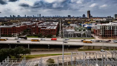
Accompanying the report are series of interactive maps depicting the economic segregation of America's 10 largest cities. Of note, "the most economically segregated large cities in America are all in Texas: San Antonio, Houston, and Dallas top the list."
FULL STORY: The Rise of Economic Segregation


City vs. State: Mayors Want Power to Require Mask Wearing to Slow Coronavirus Spread
Coronavirus cases are surging in the Lone Star State's urban areas, so mayors of nine of its largest cities asked Greg Abbott for the power to mandate the wearing of masks or facial coverings, prohibited by executive order, to slow viral spread.

Dallas Eyes Big Property Tax Increase to Cover COVID-19 Losses
Dallas will need voter approval to overcome tax increase obstacles put in place by the Texas State Legislature.
Texas Losing its Housing Affordability Advantage
Trends pre-dating Covid-19 showed housing affordability slipping away from many residents in Texas. The pandemic will likely only exacerbate the trend, according to this analysis.

Planetizen Federal Action Tracker
A weekly monitor of how Trump’s orders and actions are impacting planners and planning in America.

Map: Where Senate Republicans Want to Sell Your Public Lands
For public land advocates, the Senate Republicans’ proposal to sell millions of acres of public land in the West is “the biggest fight of their careers.”

Restaurant Patios Were a Pandemic Win — Why Were They so Hard to Keep?
Social distancing requirements and changes in travel patterns prompted cities to pilot new uses for street and sidewalk space. Then it got complicated.

Platform Pilsner: Vancouver Transit Agency Releases... a Beer?
TransLink will receive a portion of every sale of the four-pack.

Toronto Weighs Cheaper Transit, Parking Hikes for Major Events
Special event rates would take effect during large festivals, sports games and concerts to ‘discourage driving, manage congestion and free up space for transit.”

Berlin to Consider Car-Free Zone Larger Than Manhattan
The area bound by the 22-mile Ringbahn would still allow 12 uses of a private automobile per year per person, and several other exemptions.
Urban Design for Planners 1: Software Tools
This six-course series explores essential urban design concepts using open source software and equips planners with the tools they need to participate fully in the urban design process.
Planning for Universal Design
Learn the tools for implementing Universal Design in planning regulations.
Heyer Gruel & Associates PA
JM Goldson LLC
Custer County Colorado
City of Camden Redevelopment Agency
City of Astoria
Transportation Research & Education Center (TREC) at Portland State University
Camden Redevelopment Agency
City of Claremont
Municipality of Princeton (NJ)