


Richard Florida explores differing measures of inequality, considering both wage inequality and income inequality in American metropolitan cities.
The issues of wage and income inequality has never been more pressing during this political season. The rise in globalization, new technologies and productivity has resulted in a shrinking middle class and a critical divide between high-paying, knowledge-based, skilled jobs and lower-wage, unskilled jobs.
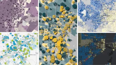
The measure of wage inequality for the metro areas in the US is based on the Theil Index which compares the wages of lower skill service and manufacturing jobs to higher skill knowledge and professional jobs. The most unequal metro cities are Huntsville, Silicon Valley, College Station-Bryan, Boulder and Durham.
Florida writes that, "While wage inequality considers the differences between salaries only, this measure of income inequality compares all income, including rents, royalties, and dividends." Based on the 2010 American Community Survey, the Gini coefficient was used to measure income inequality; the larger metros of Bridgeport-Stamford, Greater New York and Miami and smaller metros like Naples, Gainesville, Vero Beach, and College Station made the list.
When taken together, "There's only a modest association between these two measures of inequality. In fact, wage inequality accounts for just 15 percent of the variation in income equality across metros."
Florida will examine the deeper relevance and causes of this information in a future post.
FULL STORY: The Inequality of American Cities

American Community Survey: Recovery Hasn't Improved Poverty
According to the freshly released 2013 ACS by the United States Census Bureau, there have been modest, but insignificant, gains toward alleviating poverty within many urban areas.
What Lies Behind America's Rising Inequality
Wage inequality does not tell the whole picture of the growing income inequality in the United States, writes Richard Florida, who examines the myriad other factors that may be driving this trend.
Explore US Demographics With the New ACS Atlas Collection
Esri's new ACS Atlas Collection offers interactive applications that visualize the latest U.S. demographic and socio-economic data, enabling users to explore over 175 curated web maps across various thematic areas.

Planetizen Federal Action Tracker
A weekly monitor of how Trump’s orders and actions are impacting planners and planning in America.

Map: Where Senate Republicans Want to Sell Your Public Lands
For public land advocates, the Senate Republicans’ proposal to sell millions of acres of public land in the West is “the biggest fight of their careers.”

Restaurant Patios Were a Pandemic Win — Why Were They so Hard to Keep?
Social distancing requirements and changes in travel patterns prompted cities to pilot new uses for street and sidewalk space. Then it got complicated.

Platform Pilsner: Vancouver Transit Agency Releases... a Beer?
TransLink will receive a portion of every sale of the four-pack.

Toronto Weighs Cheaper Transit, Parking Hikes for Major Events
Special event rates would take effect during large festivals, sports games and concerts to ‘discourage driving, manage congestion and free up space for transit.”

Berlin to Consider Car-Free Zone Larger Than Manhattan
The area bound by the 22-mile Ringbahn would still allow 12 uses of a private automobile per year per person, and several other exemptions.
Urban Design for Planners 1: Software Tools
This six-course series explores essential urban design concepts using open source software and equips planners with the tools they need to participate fully in the urban design process.
Planning for Universal Design
Learn the tools for implementing Universal Design in planning regulations.
Heyer Gruel & Associates PA
JM Goldson LLC
Custer County Colorado
City of Camden Redevelopment Agency
City of Astoria
Transportation Research & Education Center (TREC) at Portland State University
Camden Redevelopment Agency
City of Claremont
Municipality of Princeton (NJ)