After the bust of the housing market in 2008, a striking reversal of settlement patterns in New Jersey gives cities the lead in population growth over once-booming suburbs and exurbs.


Echoing trends seen across the U.S., Tim Evans, of New Jersey Future, writes on New Jersey's changing growth patterns. "Measured any of several ways," he reports, "the pattern is clear: Between 2008 and 2011, older, more urbanized, more built-out municipalities generally grew faster than less-developed suburban, exurban, and rural municipalities."
This data comes in the face of decades of population loss for many of New Jersey's inner cities, which continued their fall between 2000 and 2008, shrinking their share of the state's population from 66.4% in 1940 to 38.3% in 2010, according to the Census Bureau.
But since the housing bubble slowed the flow of population into the suburbs, cities are not only withstanding the economic slowdown, but are growing faster than the rest of the state. "These big cities had not come close to matching the statewide growth rate since before 1930," reports Evans, "They managed this feat by gaining, on average, 17 times as many new residents annually from 2008 to 2011 as they had between 2000 and 2008."
It appears, however, that unlike the nationwide data, a closer look at the absolute numbers confirms the significance of the trend.
"Considering that New Jersey is the most developed state in the nation," argues Evans, "this trend toward redevelopment of already-built areas and away from continued development of a dwindling supply of open land is good news. If any state is in need of a rethinking of the dominant development paradigm – or is better poised to capitalize on the alternative – it is New Jersey."
Read the full story: Cities (Of All Sizes) Lead the State in Population Growth
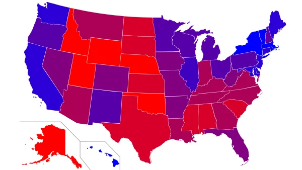
Why Americans Are Moving from Blue to Red States
In this op-ed, Arthur B. Laffer and Stephen Moore analyze the recent Census findings showing renewed migration from the Northeast and Midwest to the South and Southwest. They note the movement is clearly from blue states to red, and explain why.
South and West are Hot Destinations as Migration Resumes
New Census data shows that after a recession induced respite, "Americans have resumed moving from the Northeast and Midwest to the West and South," reports Neil Shah. Four of the nation's fastest growing large metro areas are located in Texas.
America's Fastest Growing Cities Revealed
With many of America's largest metros experiencing robust growth, Michael Sauter, Alexander Hess and Elisabeth Uible of 24/7 Wall St. have compiled a list of the fastest growing cities in the country.

Planetizen Federal Action Tracker
A weekly monitor of how Trump’s orders and actions are impacting planners and planning in America.

Eastern Nebraska is running out of electricity
Data centers and electrification are straining eastern Nebraska’s grid, throttling economic development.

Study reveals best places in the U.S. for cycling, walking
New research from Streetlight Data examines bicycle and pedestrian miles per capita in the 100 largest U.S. cities by population.

All sides of BRT debate unhappy with CDOT’s most recent move
The Colorado Department of Transportation is no longer considering center-running bus lanes for Colorado Boulevard.

Massachusetts bogs generate both power, and cranberries
Putting solar panels above farmland is one way Massachusetts is advancing toward its goal of net-zero carbon emissions by 2050.

What could the future of LA transit look like under Raman?
The mayor-elect views broken sidewalks and potholes as crises that can be fixed with better governance.

FREE Course: Walkable City 1: Why Walkability?
After describing his path towards focusing on walkability as the essence of good planning, Jeff Speck marches through his five principal reasons for making more walkable places.
Reinventing Malls: Planning Alchemy—Turning Gray Fields Into Gold
The course focuses on the opportunities and imperatives that shape reinvention of mall sites.

City of Rosemead
Rutgers University, Edward J. Bloustein School of Planning and Public Policy
One Hundred Miles
University of Michigan School for Environment and Sustainability (SEAS)
Hunter College, City University of New York (CUNY)
The Architects Foundation
City of Cambridge
The Pocatello Development Authority
The Urban Renewal Agency of the City of Pocatello