


After significant debate, the Pacheco pass route has been approved for the high-speed train between Los Angeles and the Bay Area. Next step: pass a $10 billion proposition on the November ballot.
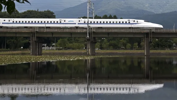
"A proposed high-speed rail network linking Southern California and Northern California will reach the Bay Area via Pacheco Pass, after approval of an environmental impact report Wednesday by the California High-Speed Rail Authority's governing board.
The 800-mile system will come from Southern California through the San Joaquin Valley, then cut westward through Merced and Santa Clara counties, with a stop in Gilroy before continuing to stops in San Jose and San Francisco.
"It's a mixture of elation and relief, in that we have taken so long to get this passed," said board member Rod Diridon of San Jose, one of the system's most vocal boosters.
The decision also signaled the end of hopes that the route might go through the Livermore Valley and the Altamont Pass through eastern Alameda County.
The next step toward building the 200 mph-plus train system would be the passage of the $10 billion Proposition 1 bond measure on the Nov. 4 ballot, which would pay nearly a third of the cost of the system's "spine" from Anaheim to San Francisco. High-speed rail officials promise the remaining money would come from private investment and federal high-speed rail legislation Congress is now considering."
FULL STORY: High-speed rail route OK'd


Car-Centric LA Suburb Looks to a Train-Oriented Future
City leaders in Rancho Cucamonga, the future western terminus of the Brightline West rail line to Las Vegas, want to reimagine the city as a transit-oriented, pedestrian-friendly community.
Texas, California Rail Projects Seek Out Private Funding
In the wake of Trump’s cuts to high-speed rail projects, rail authorities are looking to private-public partnerships to supplement their budgets.

California High-Speed Rail's Plan to Right Itself
The railroad's new CEO thinks he can get the project back on track. The stars will need to align this summer.

Planetizen Federal Action Tracker
A weekly monitor of how Trump’s orders and actions are impacting planners and planning in America.

Restaurant Patios Were a Pandemic Win — Why Were They so Hard to Keep?
Social distancing requirements and changes in travel patterns prompted cities to pilot new uses for street and sidewalk space. Then it got complicated.

Map: Where Senate Republicans Want to Sell Your Public Lands
For public land advocates, the Senate Republicans’ proposal to sell millions of acres of public land in the West is “the biggest fight of their careers.”

Maui's Vacation Rental Debate Turns Ugly
Verbal attacks, misinformation campaigns and fistfights plague a high-stakes debate to convert thousands of vacation rentals into long-term housing.

San Francisco Suspends Traffic Calming Amidst Record Deaths
Citing “a challenging fiscal landscape,” the city will cease the program on the heels of 42 traffic deaths, including 24 pedestrians.

California Homeless Arrests, Citations Spike After Ruling
An investigation reveals that anti-homeless actions increased up to 500% after Grants Pass v. Johnson — even in cities claiming no policy change.
Urban Design for Planners 1: Software Tools
This six-course series explores essential urban design concepts using open source software and equips planners with the tools they need to participate fully in the urban design process.
Planning for Universal Design
Learn the tools for implementing Universal Design in planning regulations.
Heyer Gruel & Associates PA
JM Goldson LLC
Custer County Colorado
City of Camden Redevelopment Agency
City of Astoria
Transportation Research & Education Center (TREC) at Portland State University
Camden Redevelopment Agency
City of Claremont
Municipality of Princeton (NJ)