


This article from Architect Magazine wonders what coastal cities will look like after the sea level rises.
"As the oceans heat up, they expand-up to eight inches in height already-and melting glaciers in Greenland and Antarctica continue to pump up the volume. The flow of ice into the sea has doubled over the past decade and over the next century could cause a 20-foot rise, making densely populated regions like the Nile Delta uninhabitable. In the U.S., even three more feet would flood every city on the Eastern seaboard. If you remember the aerials in An Inconvenient Truth, you know how this might look: Whole coastlines shrink as water spills inland and redraws the map of the world."
"The ascent is likely to happen gradually, so there is time to plan. Mass migration is inevitable, but abandoning every affected area isn't practical. Monumental seawalls will spring up, but New Orleans' levees are a tragic demonstration that this strategy isn't fail-safe."
"The real test will come with larger metropolitan areas. A report released in December by the Organisation for Economic Co-operation and Development (OECD), an international governmental organization based in Paris, lists New York among the 10 places most threatened by future flooding. For a wealthy city, its protection is minimal, so the images of a deluged Manhattan in the 2004 film The Day After Tomorrow may not be a Hollywood fantasy."
FULL STORY: Water World

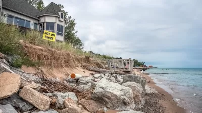
Report: Expect Regular Coastal Floods Within 15 Years
Climate change and rising seas will mean higher flood risks for cities. But when exactly will impactful flooding become a regular occurrence? New analysis by the Union of Concerned Scientists says that time is fast approaching.
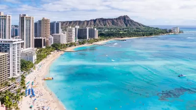
Rising Above: Innovative Solutions for Waikīkī’s Sea-Level Challenges
The University of Hawaiʻi at Mānoa’s award-winning Waikīkī sea-level rise adaptation project combines science, architecture, and community input to create scalable solutions for climate resilience and coastal flood mitigation.
How US Cities Can Prepare for Climate Disasters
Resilience, encompassing infrastructure, governance, economic strength, and social cohesion, is critical for cities to mitigate rising climate risks like flooding, wildfires, and heat, ensuring long-term recovery and adaptability.

Planetizen Federal Action Tracker
A weekly monitor of how Trump’s orders and actions are impacting planners and planning in America.

Restaurant Patios Were a Pandemic Win — Why Were They so Hard to Keep?
Social distancing requirements and changes in travel patterns prompted cities to pilot new uses for street and sidewalk space. Then it got complicated.

Map: Where Senate Republicans Want to Sell Your Public Lands
For public land advocates, the Senate Republicans’ proposal to sell millions of acres of public land in the West is “the biggest fight of their careers.”

Maui's Vacation Rental Debate Turns Ugly
Verbal attacks, misinformation campaigns and fistfights plague a high-stakes debate to convert thousands of vacation rentals into long-term housing.

San Francisco Suspends Traffic Calming Amidst Record Deaths
Citing “a challenging fiscal landscape,” the city will cease the program on the heels of 42 traffic deaths, including 24 pedestrians.

California Homeless Arrests, Citations Spike After Ruling
An investigation reveals that anti-homeless actions increased up to 500% after Grants Pass v. Johnson — even in cities claiming no policy change.
Urban Design for Planners 1: Software Tools
This six-course series explores essential urban design concepts using open source software and equips planners with the tools they need to participate fully in the urban design process.
Planning for Universal Design
Learn the tools for implementing Universal Design in planning regulations.
Heyer Gruel & Associates PA
JM Goldson LLC
Custer County Colorado
City of Camden Redevelopment Agency
City of Astoria
Transportation Research & Education Center (TREC) at Portland State University
Camden Redevelopment Agency
City of Claremont
Municipality of Princeton (NJ)