


Reid Ewing and Amir Hajrasouliha guest blog about their new article investigating the impact of street micro environments on pedestrian activity.

Guest Bloggers Reid Ewing and Amir Hajrasouliha
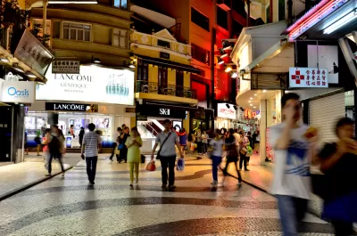
The experience of walking down a given street may have a lot to do with the micro environment of the street itself. Urban designers presume that streetscape features are important for active street life, but have little empirical evidence to back the claim. We investigated this relationship in an article in the Journal of Planning Education and Research (JPER) (Free Link until 8/31/2015).

By measuring 20 streetscape features and numerous other variables for 588 blocks in New York City, we were able to identify variables that explain pedestrian traffic volumes. We found significant positive correlations between three out of 20 streetscape features with pedestrian counts after controlling for density and other built environmental variables. The significant streetscape features are the number of pieces of street furniture, the proportion of windows on the street, and the proportion of active street frontage.
What are the implications for planning practice? First, context is important, particularly floor area ratio (FAR) and population density, within a quarter mile of commercial streets. Zoning can be amended to achieve high values of each of these variables. Accessibility to rail transit can have positive impact on street life. In addition, streets themselves should have high FARs and predominantly retail frontage.
From the perspective of urban design practice, it is important to know which streetscape features have significant relationship to pedestrian activity and how to operationalize these features. The first feature is street furniture, defined as all kinds of signs, benches, parking meters, trash cans, newspaper boxes, bollards, street lights, and so forth, anything at human scale that increases the complexity of the street. Providing urban furniture and specifically urban seating is a common recommendation for activating public spaces. Our study, verified the power of this recommendation. However, it is important to note that this recommendation can also cause a not so rare practical error among urban designers. The perception that installing urban furniture guarantees or increases pedestrian activities without taking into account all other important factors, such as land use, public safety, or other design elements is just simply not accurate.

The second feature is "windows as a percentage of ground floor façade," which is a common operational definition of transparency. Street vitality highly depends on its interaction with adjacent buildings; and high level of transparency at the ground level can facilitate this interaction. The last feature is the percentage of active uses, defined as shops, restaurants, public parks, and other uses that generate significant pedestrian traffic. Inactive uses include blank walls, driveways, parking lots, vacant lots, abandoned buildings, and offices with no apparent activity. In regard to residential uses, when the density is more than 10 units per acre, we assume that the land use is active. A lesson from this finding is to monitor land use changes at street level before investing in streetscape projects. For example, a corridor that is losing its commercial identity to non-active uses may not be a preliminary priority for becoming a pedestrian-dominated street.
Blog post by Reid Ewing (Director of the Metropolitan Research Center, University of Utah) and Amir Hajrasouliha (University of Utah). Other authors include, Kathryn Neekerman, Columbia University, Marine Purciel-HIlle, Human Impact Partners, and Bill Greene, NYU Stern.
Open Access Until August 31, 2015


Rethinking Redlining
For decades we have blamed 100-year-old maps for the patterns of spatial racial inequity that persist in American cities today. An esteemed researcher says: we’ve got it all wrong.

Montreal Mall to Become 6,000 Housing Units
Place Versailles will be transformed into a mixed-use complex over the next 25 years.

Planetizen Federal Action Tracker
A weekly monitor of how Trump’s orders and actions are impacting planners and planning in America.

Addressing Rural Homelessness in Kentucky
A Kentucky Lantern series focuses on the challenges unhoused Kentuckians face and efforts to provide support and assistance.

Santa Clara County Dedicates Over $28M to Affordable Housing
The county is funding over 600 new affordable housing units via revenue from a 2016 bond measure.

Why a Failed ‘Smart City’ Is Still Relevant
A Google-backed proposal to turn an underused section of Toronto waterfront into a tech hub holds relevant lessons about privacy and data.
Urban Design for Planners 1: Software Tools
This six-course series explores essential urban design concepts using open source software and equips planners with the tools they need to participate fully in the urban design process.
Planning for Universal Design
Learn the tools for implementing Universal Design in planning regulations.
City of Camden Redevelopment Agency
City of Astoria
Transportation Research & Education Center (TREC) at Portland State University
Regional Transportation Commission of Southern Nevada
Toledo-Lucas County Plan Commissions