


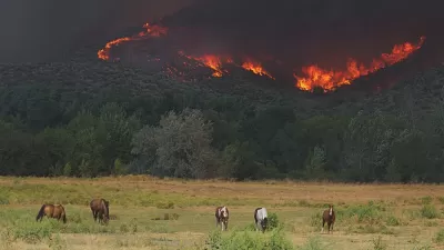
WIFIRE, a real-time and data-driven simulation, prediction, and visualization technology, combines satellite and remote sensor data to forecast the potential spread of wildfires.
As InformationWeek reports, a team of researchers, technologists, and firefighters from the University of California at San Diego and the University of Maryland, with support from the National Science Foundation, have come together to create a far-reaching simulation, visualization, and prediction model for understanding wildfires called WIFIRE. Although still partially in development, WIFIRE has some prototypes and pilot applications now available.
Once completed, WIFIRE will be a vast open network with specialized interfaces and messages sent to receivers. Indeed, according to Elena Malykhina, "having such infrastructure in place would be especially useful during massive environmental events like the wildfires that California firefighters have been battling."
With summer wildfires expected to increase in the next 50 years, WIFIRE is a high-resolution, life-saving data tool with the potential to understand the patterns of wildfires.
FULL STORY: Big Data Tackles Wildfire Control

Wildfires Prompt Forestry Debate on Climate Change
While forests sequester atmospheric carbon dioxide, wildfires release enormous amounts of greenhouse gases as they increase in frequency and intensity from climate change.

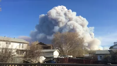
Study: Forest Fires Have Doubled in the Western United States
Wildfires ravaged the western United States again this year, reflecting the new normal of climate change.
Thank Climate Change and Sprawl for Worsening Wildfires
Along with climate conditions, urban sprawl is intensifying wildfires and increasing the damage they do.

Planetizen Federal Action Tracker
A weekly monitor of how Trump’s orders and actions are impacting planners and planning in America.

Congressman Proposes Bill to Rename DC Metro “Trump Train”
The Make Autorail Great Again Act would withhold federal funding to the system until the Washington Metropolitan Area Transit Authority (WMATA), rebrands as the Washington Metropolitan Authority for Greater Access (WMAGA).

The Simple Legislative Tool Transforming Vacant Downtowns
In California, Michigan and Georgia, an easy win is bringing dollars — and delight — back to city centers.

The States Losing Rural Delivery Rooms at an Alarming Pace
In some states, as few as 9% of rural hospitals still deliver babies. As a result, rising pre-term births, no adequate pre-term care and "harrowing" close calls are a growing reality.

The Small South Asian Republic Going all in on EVs
Thanks to one simple policy change less than five years ago, 65% of new cars in this Himalayan country are now electric.

DC Backpedals on Bike Lane Protection, Swaps Barriers for Paint
Citing aesthetic concerns, the city is removing the concrete barriers and flexposts that once separated Arizona Avenue cyclists from motor vehicles.
Urban Design for Planners 1: Software Tools
This six-course series explores essential urban design concepts using open source software and equips planners with the tools they need to participate fully in the urban design process.
Planning for Universal Design
Learn the tools for implementing Universal Design in planning regulations.
Smith Gee Studio
City of Charlotte
City of Camden Redevelopment Agency
City of Astoria
Transportation Research & Education Center (TREC) at Portland State University
US High Speed Rail Association
City of Camden Redevelopment Agency
Municipality of Princeton (NJ)