


The best solution to many transportation problems is to improve transport system diversity so travelers can choose the best option for each trip. This requires more comprehensive and multi-modal planning. Not everybody is ready.

We live in interesting times for planning! Are you ready?
The Twentieth Century was the period of automobile ascendency during which personal motor vehicle travel grew from almost nothing in 1900, to peak about the year 2000. During that century it made sense to devote considerable resources to road building in order to accommodate growing motor vehicle traffic. We now have a mature roadway system that allows motorists to drive from nearly any origin to any destination with a high degree of convenience and safety. The main transportation problems we face – urban traffic congestion, inadequate mobility options for non-drivers, and various external costs – are often best solved by increasing transport system diversity (or options), and using demand management strategies that encourage travelers to use the most efficient mode for each trip: walking and cycling for local travel, public transit on busy urban corridors, and automobiles when they are truly optimal overall. Current demographic and economic trends are increasing demand for walking, cycling and public transport. This is not to suggest that everybody wants to give up driving altogether, but many people would prefer to drive less and rely more on alternatives, provided they are convenient and safe. Meeting these demands requires a new transport planning paradigm that is more comprehensive and multi-modal.

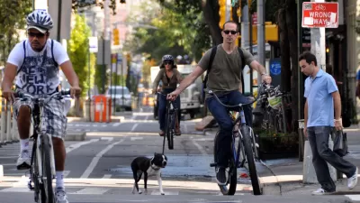
The U.S. Bicycle Route System is an example of efforts to improve transportation system divesity, which has stimulated debate over the value of multi-modalism.
Most transport professionals I know embrace this new paradigm; they support walking, cycling and public transit improvements, complete streets policies, and other transportation demand management strategies. However, there are still holdouts who want to continue automobile-oriented planning.
This is illustrated by a debate I am having with Bob Poole of the Reason Foundation. In Surface Transportation Innovations #121, Bob criticized the U.S. Bicycle Route System as wasteful and unfair to motorists, assumptions that I challenged in my Planetizen blog, Mythbusting: Exposing Half-Truths That Support Automobile Dependency. He responded to some, but not all, of the points I raised in Surface Transportation Innovations #123. Here is what he wrote:
Further and More on Bicycle Routes (and Lanes)
My November article expressing some concerns about plans for a U.S. Bicycle Route System brought a number of responses, prompting this follow-up article. First I had a good conversation with David Lee of Florida DOT, who's been working on development of the Florida segment of U.S. Bike Route 1. He explained that the program does not involve building anything; it merely designates appropriate routes along existing highways and streets that would be suitable for longer-distance bike travel. These points were reinforced by Ginny Sullivan of Adventure Cycling in Montana, the leading national group supporting the U.S. Bicycle Route System. Both Lee and Sullivan pointed out that this effort dates back many years and is being coordinated by AASHTO and FHWA.
I was relieved to learn that this system is not using either federal or state highway user tax money to build bike routes, for two reasons. First, long-distance bike travel infrastructure should not be a federal government function under any sensible parceling out of appropriate roles for federal, state, and local governments. Second, to the extent that governments are going to provide such infrastructure—as many city and county governments are now doing—there is no justification for making highway users (rather than all local taxpayers—or bicyclists) pay for such facilities.
But there followed an attack on what I wrote by Todd Littman of the Victoria Transport Policy Institute. In two posts on Planetizen, he took after both my article about interstate bike routes and a Weekly Standard article by Christopher Caldwell, "Drivers Get Rolled," about the growing movement to add bike lanes to city streets. Caldwell, with some hyperbole, argued that "bike riders don't 'share' the road so much as take it over," and elsewhere stated that "There are probably a million dedicated cyclists in this country, bent on taking over a quarter or a third of the nation's road space" as bike-only lanes.
Littman's answer to this was a numerical example: "A typical urban arterial has a 60 foot width right of way. A typical bike lane is 3 to 4.5 feet wide, so two [bike] lanes require 10-15% of total width." But let's look at what groups like Smart Growth America and other groups promoting "complete streets" and "road diets" are actually advocating, unmentioned in Littman's posts. It's easy to go online and find their recommended before/after urban arterial cross sections. The "before" cross section typically has four 11-ft. travel lanes (two in each direction) and a parking lane on each side. The "after" vision has just one 11-ft. travel lane in each direction, two 5 ft. bike lanes and 10 to 12 feet in the center as a landscaped median plus left-turn lanes at intersections. So the basic vehicular throughput capacity of the arterial is cut in half by these designs. Plans like these are popping up all over the country, often with the support of local planners and media.
Local streets and roads are mostly supported by local taxes, such as property and sales taxes. So it is appropriate for cities and counties to decide on whether to spend some of their transportation money adding sidewalks where there aren't any, and bike lanes where they don't reduce needed roadway capacity for the vast majority of citizens. But since in most states the major arterials in urban areas are state highways, state DOTs have a responsibility to protect their lane capacity from "road diets."
To his credit, Poole acknowledges that he was a little rash to criticize the U.S. Bike Route Program before investigating its funding. However, in addition to misspelling my name, he ignores the larger debate over the valuation of cycling improvements, and more generally, the valuation of investing in a more diverse transportation system. Let’s examine his arguments.
“long-distance bike travel infrastructure should not be a federal government function under any sensible parceling out of appropriate roles for federal, state, and local governments.”
Why not? Federal highways serve many types of trips, including a significant amount of recreational travel, and even motorists driving to bicycle trails. Why should a bicycle trip be valued less than an automobile trip that serves the same purpose?
Perhaps Bob is arguing that the federal role should be limited to serving intercity (long-distance) trips, which was apparently the original intent of the Interstate Highway System. However, that was quickly abandoned. The federal highway program built urban freeways through most cities and many towns that carry numerous short trips; in many cases they are the only road on a corridor. Improving alternative modes can help reduce traffic problems on those federally funded highways.
“Second, to the extent that governments are going to provide such infrastructure—as many city and county governments are now doing—there is no justification for making highway users (rather than all local taxpayers—or bicyclists) pay for such facilities.”
When Bob writes “highway users,” he apparently means motorists (after all, cyclists riding on highways are “users”), and is arguing that, since motor vehicle user fees help fund roadways through fuel taxes and other special charges, it is unfair to spend such fees on bicycle facilities, reflecting the “user pays” principle.
I too support the user pays principle when it reflects economic efficiency and equity objectives. However, as discussed in my blog, Who Subsidizes Whom?, motor vehicle fees currently fund less than half of total roadway costs, the remainder are funded by general taxes that residents pay regardless of how they travel, and since cyclists impose much lower roadway costs per mile and generally ride fewer annual miles than motorists drive, people who rely primarily on walking and cycling tend to pay more than their share of roadway costs, and they subsidize motorists. It is hypocritical to attack cycling investments without also attacking the much larger subsidies for roads and parking facilities not funded by user fees.
Poole also ignores ways that motorists benefit from alternative modes, through reduced traffic and parking congestion, reduced accident risk (many safety programs limit driving by higher-risk groups such as teenagers, seniors and drunks; to be successful and fair this requires transport alternatives), and reduced chauffeuring burdens. To the degree this is true, motorists have every reason to help support walking, cycling and public transit improvements.
My column criticized the claim that cyclists are "bent on taking over a quarter or a third of the nation's road space as bike-only lanes." Poole countered by citing a road diet (also called road rightsizing) design that involves converting four through traffic lanes into two through lanes, one turn lane and two bike lanes. He concludes,
“the basic vehicular throughput capacity of the arterial is cut in half by these designs.”
This is just one of many road diet configurations, and it does not really reduce vehicular throughput by half, because the reduction in traffic lanes is offset by reduced traffic friction provided by the center turn and bike lanes, and lower traffic speeds, which tend to increase capacity per lane. (Arterial capacity tends to peak at 25-35 miles per hour. To see why lower traffic speeds tend to increase roadway capacity view Washington State Secretary of Transportation, Doug MacDonald's rice and funnel demonstration.)
Before-and-after studies indicate that on arterials with less than 10,000 daily or 1,000 peak-period vehicles, 4-to-3 lane road diets cause minimal motor vehicle traffic capacity reductions, and can increase total personal travel capacity by accommodating more pedestrian and bicycle traffic. For instance, a recent Prospect Park West road diet approximately maintained vehicle traffic speeds, increased total capacity (car and bike trips) about 15%, and significantly reduced severe crashes - those requiring medical relief. Road diets also tend to support local businesses by creating more attractive commercial areas.
Bob Poole is a trained engineer, so he should understand technical issues, such as how to accurately measure roadway capacity, and the tradeoffs between speed, safety and local environmental quality.
Advocates of automobile-oriented planning often argue that since most trips are currently made by automobile, their needs should have priority over other modes, but this reflects a self-fulfilling prophecy, since our current mode share results from decades of planning that favored automobile travel over alternative modes. When communities improve walking and cycling conditions, use of these modes often increases significantly, indicating latent demand. Accommodating this demand directly benefits users, and as described previously indirectly benefits motorists. It is therefore wrong to imply that devoting road space or money to pedestrian and bicycling facilities is inefficient or unfair.
Of course, not every four lane road is suitable for road diets, but when all impacts are considered, many urban arterials could benefit from complete streets treatments that better balance the needs of diverse users and uses. Poole assumes that motor vehicle traffic speed is the only roadway planning criteria, ignoring safety, mobility of other modes, and the quality of the street environment.
Least-Cost transportation planning refers to planning that selects the most cost effective option overall, considering all benefits and costs. This means, for example, that transportation agencies invest in alternative modes and demand management strategies when they are more cost effective than expanding roads or parking facilities. This is simply rational resource allocation, and also tends to provide social equity benefits by improving transport options for disadvantaged people. The main obstacle to least-cost planning is rigid funding restrictions, such as Poole recommends, which allocate funds to roadway expansions even if alternatives are cheaper.
Consider another perspective, funding based on mode share. According to the National Household Travel Survey, in 2009 about 12% of all trips were by walking and cycling, and this share tends to increase in communities that improve walking and cycling conditions. This suggests that it is efficient and fair to invest at least 12% of total transportation budgets on walking and cycling improvements, and perhaps more to catch up after decades of underinvestment and to accommodate latent demand, yet, federal nor state transportation budgets generally devote just 1-2% to these modes. Critics of increased walking and cycling funding are being selfish, demanding more than their fair share of public resources.
An efficient and equitable transportation system is diverse, so users can choose the best mode for each trip. Creating such a system requires more comprehensive and multi-modal planning which allows transportation resources, funding and road space, to be devoted to the most efficient option, considering all impacts. This may sometimes include roadway expansions, but in regions with mature roadway systems this usually means improving transport options and demand management strategies.
What do you think, Bob? Are you ready to consider other modes and planning objectives?
For More Information
AARP (2009), Planning Complete Streets for an Aging America, American Association for Retired Persons Public Policy Institute.
Dan Burden and Todd Litman (2011), “America Needs Complete Streets,”ITE Journal, Vol. 81, No. 4, April, pp. 36-43.
Complete Streets is a campaign to promote roadway designs that effectively accommodate multiple modes and support local planning objectives.
Eric Dumbaugh (2005), “Safe Streets, Livable Streets,”Journal of the American Planning Association, Vol. 71, No. 3, pp. 283-300.
HSIS (2010), Evaluation of Lane Reduction “Road Diet” Measures on Crashes Summary Report Research, Development, and Technology, Highway Safety Information System (www.hsisinfo.org).
Todd Litman (2012), Evaluating Complete Streets: The Value of Designing Roads For Diverse Modes, Users and Activities, Victoria Transport Policy Institute.
NACTO (2012), Urban Street Design Guide, National Association of City Transportation Officials (www.nacto.org).
NYCDOT (2012), Measuring the Street: New Metrics for 21st Century Streets, New York City Department of Transportation.
PPS (2012), Rightsizing Streets, Project for Public Spaces.
Carol H. Tan (2011), “Going On A Road Diet: Lane Reduction Can Increase Safety For Pedestrians, Bicyclists, And Motorists While Improving The Quality Of Life In Downtowns Across The Country,”Public Roads, U.S. Federal Highway Administration.
WSDOT (2011), Washington’s Complete Streets and Main Street Highways: Case Study Resource, Community Planning and Development, Washington State Department of Transportation (www.wsdot.wa.gov/LocalPrograms/Planning).


Maui's Vacation Rental Debate Turns Ugly
Verbal attacks, misinformation campaigns and fistfights plague a high-stakes debate to convert thousands of vacation rentals into long-term housing.

Planetizen Federal Action Tracker
A weekly monitor of how Trump’s orders and actions are impacting planners and planning in America.

In Urban Planning, AI Prompting Could be the New Design Thinking
Creativity has long been key to great urban design. What if we see AI as our new creative partner?

King County Supportive Housing Program Offers Hope for Unhoused Residents
The county is taking a ‘Housing First’ approach that prioritizes getting people into housing, then offering wraparound supportive services.

Researchers Use AI to Get Clearer Picture of US Housing
Analysts are using artificial intelligence to supercharge their research by allowing them to comb through data faster. Though these AI tools can be error prone, they save time and housing researchers are optimistic about the future.

Making Shared Micromobility More Inclusive
Cities and shared mobility system operators can do more to include people with disabilities in planning and operations, per a new report.
Urban Design for Planners 1: Software Tools
This six-course series explores essential urban design concepts using open source software and equips planners with the tools they need to participate fully in the urban design process.
Planning for Universal Design
Learn the tools for implementing Universal Design in planning regulations.
planning NEXT
Appalachian Highlands Housing Partners
Mpact (founded as Rail~Volution)
City of Camden Redevelopment Agency
City of Astoria
City of Portland
City of Laramie