


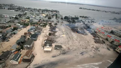
Citing a "near-term risk" of rising tides, city planners in Boston are grappling with how to prepare residents and businesses for the effects of climate change, reports Monica Brady-Myerov.
With sea levels around Boston expected to rise anywhere between 2 to 6 feet by the end of the century, and storm surge models showing parts of the city could find themselves under 10 feet of water multiple times a year by 2050, the city is planning for how to deal with what officials consider a "near-term risk."
Although the city has a comprehensive climate action plan in place, residents like Magdalena Ayed, who lives in publicly-funded housing along the waterfront, "wishes city officials would talk to Boston residents about rising sea
level and provide guidance on what local residents should do in
response."
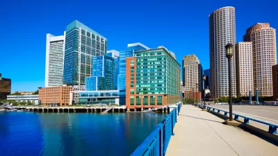
Some businesses, like the Boston-based healthcare group Partners for Healthcare, which is
building a new rehabilitation hospital in downtown Boston, are taking matters into their own hands. They've designed their hospital to sit more than 12 feet higher
than sea level, have located all patient rooms on upper floors, and placed the mechanical equipment on the roof.
FULL STORY: Boston Plans For 'Near-Term Risk' Of Rising Tides

Adapting to Rising Seas in Boston with Venice-Style Canals
The latest example of a coastal city designing urban resilience as both amenity and infrastructure—a plan to build Venice-style canals in Boston.
How Coastal Communities Can Adapt to the Effects of Climate Change
Dave Hampton, an architect and a principal at the consulting firm re:ground llc reviews last month’s "MIT Sea Grant’s Climate Change Symposium: Sustaining Coast Cities."
Boston’s Seaport District, Where Building Started Before Flood Preparation
The Boston waterfront has been booming, but the area is extremely vulnerable to climate change and rising sea levels. Measures to address those risks have come just recently.

Planetizen Federal Action Tracker
A weekly monitor of how Trump’s orders and actions are impacting planners and planning in America.

Map: Where Senate Republicans Want to Sell Your Public Lands
For public land advocates, the Senate Republicans’ proposal to sell millions of acres of public land in the West is “the biggest fight of their careers.”

Restaurant Patios Were a Pandemic Win — Why Were They so Hard to Keep?
Social distancing requirements and changes in travel patterns prompted cities to pilot new uses for street and sidewalk space. Then it got complicated.

Platform Pilsner: Vancouver Transit Agency Releases... a Beer?
TransLink will receive a portion of every sale of the four-pack.

Toronto Weighs Cheaper Transit, Parking Hikes for Major Events
Special event rates would take effect during large festivals, sports games and concerts to ‘discourage driving, manage congestion and free up space for transit.”

Berlin to Consider Car-Free Zone Larger Than Manhattan
The area bound by the 22-mile Ringbahn would still allow 12 uses of a private automobile per year per person, and several other exemptions.
Urban Design for Planners 1: Software Tools
This six-course series explores essential urban design concepts using open source software and equips planners with the tools they need to participate fully in the urban design process.
Planning for Universal Design
Learn the tools for implementing Universal Design in planning regulations.
Heyer Gruel & Associates PA
JM Goldson LLC
Custer County Colorado
City of Camden Redevelopment Agency
City of Astoria
Transportation Research & Education Center (TREC) at Portland State University
Camden Redevelopment Agency
City of Claremont
Municipality of Princeton (NJ)