


Mark Guarino investigates the controversial construction of an expansive new development in the historic Lower Mid-City neighborhood of New Orleans.
Officials hope that BioDistrict New Orleans, a 1,500 acre medical and science corridor, will help to diversify the city's economy away from tourism, writes Guarino. A new veterans hospital was in the works before Katrina hit, but after the storm damaged the existing facility, plans were was accelerated and expanded. Additionally, the site will now include a 424-bed medical teaching facility as well as a new medical center and teaching hospital for Lousiana State.
However, 265 historic homes in the area, which is recognized by the National Register of Historic Places, stand in the way of the project, writes Guarino. Some have already been demolished, though at least 80 are being relocated by a non-profit group. With further demolitions on the way, the project is drawing fire from preservationists, writes Guarino:
"Critics say the project is a slap in the face of residents who spent three years after Katrina using federal Road Home funds to fix up their homes...The planned district is described by Sandra Stokes, executive vice chair of the Foundation for Historical Louisiana in Baton Rouge, as 'suburban sprawl in the most culturally significant urban environment in the US.'
'You're not revitalizing your downtown,' she says. 'You're evacuating your downtown and calling it economic development.'"
FULL STORY: New Orleans makeover: economic boost or loss of a historical legacy?

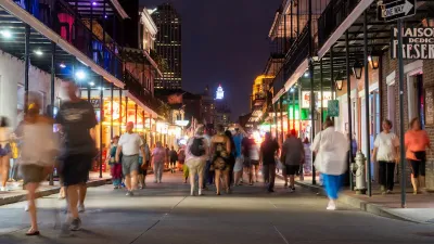
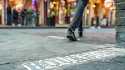
Bourbon Street Could Be a Model for Pedestrian Spaces
The conversation around pedestrianizing public streets isn’t new — think Times Square. Could one of America’s oldest streets lead the way in a revival of the pedestrian mall?

New Orleans Seeks Consultants for $8M Tree Planting Initiative
The city seeks consultancy firms to help implement an $8 million USDA Urban and Community Forestry Grant, advancing its goal of planting 40,000 trees by 2030 and strengthening urban sustainability and resilience.
New Orleans Makes Push for Accessibility Improvements Ahead of Super Bowl
Major sporting events like the Olympics and the Super Bowl can serve as catalysts for major changes in transportation infrastructure and accessibility.

Planetizen Federal Action Tracker
A weekly monitor of how Trump’s orders and actions are impacting planners and planning in America.

Map: Where Senate Republicans Want to Sell Your Public Lands
For public land advocates, the Senate Republicans’ proposal to sell millions of acres of public land in the West is “the biggest fight of their careers.”

Restaurant Patios Were a Pandemic Win — Why Were They so Hard to Keep?
Social distancing requirements and changes in travel patterns prompted cities to pilot new uses for street and sidewalk space. Then it got complicated.

Platform Pilsner: Vancouver Transit Agency Releases... a Beer?
TransLink will receive a portion of every sale of the four-pack.

Toronto Weighs Cheaper Transit, Parking Hikes for Major Events
Special event rates would take effect during large festivals, sports games and concerts to ‘discourage driving, manage congestion and free up space for transit.”

Berlin to Consider Car-Free Zone Larger Than Manhattan
The area bound by the 22-mile Ringbahn would still allow 12 uses of a private automobile per year per person, and several other exemptions.
Urban Design for Planners 1: Software Tools
This six-course series explores essential urban design concepts using open source software and equips planners with the tools they need to participate fully in the urban design process.
Planning for Universal Design
Learn the tools for implementing Universal Design in planning regulations.
Heyer Gruel & Associates PA
JM Goldson LLC
Custer County Colorado
City of Camden Redevelopment Agency
City of Astoria
Transportation Research & Education Center (TREC) at Portland State University
Camden Redevelopment Agency
City of Claremont
Municipality of Princeton (NJ)