


Walkable Los Angeles. Casual visitors may be surprised to learn that this is not an oxymoron.
Walkable Los Angeles. Casual visitors may be surprised to learn that this is not an oxymoron.
 Many LA suburbs are in fact incorporated satellite cities, built upon a classic street grid that makes them inherently walkable. These central nodes were well served by the Pacific Electric Railway until the 1930's, when the automobile began to assert itself. So it wasn't long ago that one could travel the region on foot and by rail.
Today, a No Man's Land between freeway barriers greets visitors as they drive from airport to hotel to tourist destination. This backdrop - parking lots, warehouses, strip malls - presents the city as entirely devoted to the car.
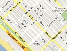
 But this impression is superficial. The older neighborhoods, rich in cultural and architectural history, remain quite walkable. Within city limits: Downtown, Hollywood, Los Feliz, and others are navigable on foot . Outside of the city, central portions of Pasadena, Santa Monica, and Long Beach are some of the most pedestrian-friendly spots anywhere.
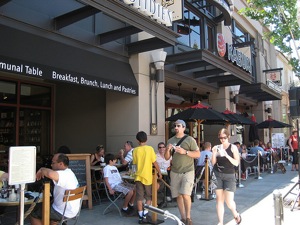
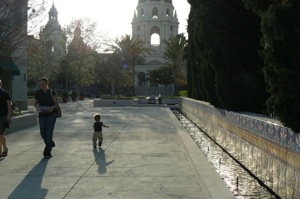
Pasadena in particular has made great efforts to restore and maintain its urban character since it adopted a visionary General Plan in 1992 . It has directed new development to the central core while incorporating landmarks that date to the City Beautiful era (City Hall, the Civic Auditorium, the Pasadena Public Library). There are whole blocks dedicated to parks, plazas and inner courtyards that engage rather than detract from the street. Two main avenues - Colorado and Lake - now form a continuous retail corridor that is accessible from nearby residential neighborhoods. In short, Pasadena is a model for how to weave public space, retail and housing to promote walking.
 Even in pedestrian-oriented Los Angeles, roads tend to be wider and blocks tend to be larger than the ideal because traffic engineers have long tried to accommodate all of those cars circulating through the metropolis.
What's missing is transit connectivity throughout the region. Mayor Villaraigosa's 30/10 plan, which seeks federal aid to complete an ambitious transit expansion in 10 years instead of 30, makes sense because the city has already waited too long to tackle traffic congestion. The subway and light rail extensions to popular destinations on the Westside should increase ridership systemwide. The plan will also help to link LA's most walkable centers, which were designed for transit and are poised to become transit-rich communities again.
Photos:
1. Santa Monica via Google Maps
2. Old Pasadena by La Citta Vita in Planetizen's Flickr Pool
3. Pasadena City Hall


What Will the 'Third Los Angeles' Look Like?
Architecture critic Christopher Hawthorne describes an L.A. in flux, at once beholden to its postwar image and pushing in a new direction. The city, he says, faces existential questions on a scale unmatched elsewhere in the nation.

The Vast Potential of the Right-of-Way
One writer argues that the space between two building faces is the most important element of the built environment.

How the ‘Social Field of View’ Impacts Street Life
The vibrancy of a neighborhood may be defined by what people can see in their immediate vicinity.

Planetizen Federal Action Tracker
A weekly monitor of how Trump’s orders and actions are impacting planners and planning in America.

Chicago’s Ghost Rails
Just beneath the surface of the modern city lie the remnants of its expansive early 20th-century streetcar system.

Amtrak Cutting Jobs, Funding to High-Speed Rail
The agency plans to cut 10 percent of its workforce and has confirmed it will not fund new high-speed rail projects.

Ohio Forces Data Centers to Prepay for Power
Utilities are calling on states to hold data center operators responsible for new energy demands to prevent leaving consumers on the hook for their bills.

MARTA CEO Steps Down Amid Citizenship Concerns
MARTA’s board announced Thursday that its chief, who is from Canada, is resigning due to questions about his immigration status.

Silicon Valley ‘Bike Superhighway’ Awarded $14M State Grant
A Caltrans grant brings the 10-mile Central Bikeway project connecting Santa Clara and East San Jose closer to fruition.
Urban Design for Planners 1: Software Tools
This six-course series explores essential urban design concepts using open source software and equips planners with the tools they need to participate fully in the urban design process.
Planning for Universal Design
Learn the tools for implementing Universal Design in planning regulations.
Caltrans
City of Fort Worth
Mpact (founded as Rail~Volution)
City of Camden Redevelopment Agency
City of Astoria
City of Portland
City of Laramie