


Shared streets, the contemporary vernacular used to describe streets that have been intentionally redesigned to remove exclusive boundaries for pedestrians, bicyclists, cars, etc., work well within a special set of conditions. It is, in reality, just a new way of describing the original use of streets (see this previous post for more on that). The most promising candidates for shared streets are those where traffic volumes are not too heavy, the route is not a critical corridor for vehicular through-traffic, activities and attractions along the street are plentiful, short distance connectivity is viable, and a critical mass of pedestrians (perhaps enough to pack sidewalks at certain times) exists. A shared street may also be suitable in places where there is a desire to induce such conditions; however, care must be taken to understand the larger network effects of shifting or slowing down vehicular traffic. But in some instances, seemingly unrelated changes to traffic patterns or the effects of a coincidental collection of the above conditions sometimes go unnoticed until a street that may have been all about cars gradually shifts into something I refer to as a “de facto shared street”.

Shared streets, the contemporary vernacular used to describe streets that have been intentionally redesigned to remove exclusive boundaries for pedestrians, bicyclists, cars, etc., work well within a special set of conditions. It is, in reality, just a new way of describing the original use of streets (see this previous post for more on that). The most promising candidates for shared streets are those where traffic volumes are not too heavy, the route is not a critical corridor for vehicular through-traffic, activities and attractions along the street are plentiful, short distance connectivity is viable, and a critical mass of pedestrians (perhaps enough to pack sidewalks at certain times) exists. A shared street may also be suitable in places where there is a desire to induce such conditions; however, care must be taken to understand the larger network effects of shifting or slowing down vehicular traffic. But in some instances, seemingly unrelated changes to traffic patterns or the effects of a coincidental collection of the above conditions sometimes go unnoticed until a street that may have been all about cars gradually shifts into something I refer to as a "de facto shared street".
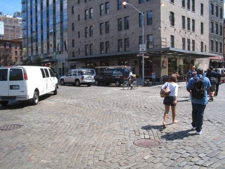
A few weeks ago I referred to the chaos perceived by drivers at Gansevoort Plaza, in Manhattan's Meat Packing District, where pedestrians, bicyclists, cars, taxis, and buses mingle in an informal and unplanned way, as a de facto shared street. This is in contrast to the shared streets that have been more recently implemented by professional planners and engineers as a means of changing the way areas between property lines are perceived by people; that is, from streets designed for cars to public spaces equally accessible by everyone. While the newly redesigned Gansevoort Plaza was specifically crafted to enhance the shared street characteristics of the space while staying within the legal confines of New York City street design, its fundamental design criteria were based on the observed dynamic interaction amongst modes across the swath of historical Belgian block that many believe contributed to the area's growing appeal. In fact, when we began the conceptual design process, we based the original redesign concepts on that activity, with a little sprinkling of the traffic patterns observed in another Manhattan de facto shared street, Union Square West (photo further down the page). The end result is something that, due to being an early proof-of-concept in a city where aggressive change never comes easy, does not meet the letter, but rather the spirit, of shared street design.
Gansevoort Plaza in Manhattan's Meat Packing District Before Redesign
Over years of roaming through Manhattan, it turns out that the Big Apple is home to an interesting smattering of urban places that have, for various reasons, developed independently, to an extent, as de facto shared streets. Photos and short captions of some less obvious examples are provided below. Perhaps the most valuable take-away from this exercise is to demonstrate that the shared street concept is not nearly as foreign to the American psyche as some may say, and that if you look closely enough, you might find examples of de facto shared streets in your city too. Enjoy!
Broad Street in downtown Manhattan enjoys limited traffic due to security restrictions around Wall Street. The result is an area where pedestrians frequently spill out into the street, since sidewalks are narrow and frequently squeezed by scaffolding. Cars roll slowly and mix with pedestrians and bicyclists. The asphalt isn't so appealing, but the prospects are!
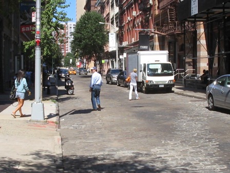
Wooster Street is an example of the de facto shared street feel of many SOHO streets. Low vehicular traffic volumes, big rushes of tourists on foot, and bumpy, Belgian block paving contribute to the effect.
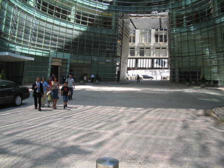
Bloomberg Circle in Midtown is a quasi-public street (didn't research the consents here) where limited signage, minimal traffic, and strong desire lines (to cross the circle rather than walk around it) combine with pavers to create a de facto shared street.
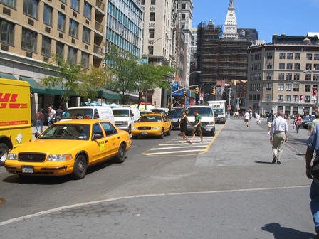
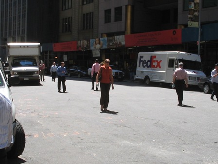
Union Square West is a bit chaotic since striping and spaces are so broad, but pedestrian volumes to and from the park result in an informal mingling of foot and vehicular traffic. There is a lot of opportunity to redesign this area, but even the current de facto shared street conditions were enough to build a friendly analogy and inspire roadway design elements of the new Gansevoort Plaza just a few blocks to the west.

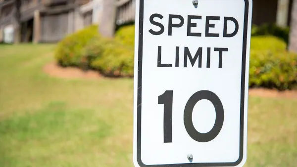
Washington Passes First US ‘Shared Streets’ Law
Cities will be allowed to lower speed limits to 10 miles per hour and prioritize pedestrians on certain streets.

‘Togetherness’ as a Synonym for ‘Transportation’
Transportation is a fundamental aspect of community cohesion, and should be considered a synonym for togetherness.
Opinion: It's Time To Put People Ahead of Cars in SoHo
A proposal from SoHo Broadway Initiative aims to prioritize pedestrian and bike infrastructure and discourage car traffic to make the neighborhood safer and more comfortable for the people who live and work there.

Planetizen Federal Action Tracker
A weekly monitor of how Trump’s orders and actions are impacting planners and planning in America.

Map: Where Senate Republicans Want to Sell Your Public Lands
For public land advocates, the Senate Republicans’ proposal to sell millions of acres of public land in the West is “the biggest fight of their careers.”

Restaurant Patios Were a Pandemic Win — Why Were They so Hard to Keep?
Social distancing requirements and changes in travel patterns prompted cities to pilot new uses for street and sidewalk space. Then it got complicated.

Albuquerque Route 66 Motels Become Affordable Housing
A $4 million city fund is incentivizing developers to breathe new life into derelict midcentury motels.

DC Area County Eliminates Bus Fares
Montgomery County joins a growing trend of making transit free.

Platform Pilsner: Vancouver Transit Agency Releases... a Beer?
TransLink will receive a portion of every sale of the four-pack.
Urban Design for Planners 1: Software Tools
This six-course series explores essential urban design concepts using open source software and equips planners with the tools they need to participate fully in the urban design process.
Planning for Universal Design
Learn the tools for implementing Universal Design in planning regulations.
Heyer Gruel & Associates PA
JM Goldson LLC
Custer County Colorado
City of Camden Redevelopment Agency
City of Astoria
Transportation Research & Education Center (TREC) at Portland State University
Camden Redevelopment Agency
City of Claremont
Municipality of Princeton (NJ)