


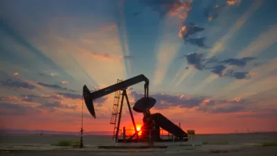
An exhibition in Houston organized by the Center for Land Use Interpretation looks at how the oil industry has transformed the landscape of Texas.
"Texas Oil: Landscape of an Industry will be the culmination of the CLUI's study of Texas and will show how the extraction and refining of oil has sculpted the state's terrain. The exhibition will open with a "landscan" video, an extended aerial shot of petroleum refineries and shipping yards that shows the massive scale of these places. In addition to this projection, the galleries will be filled with CLUI photographs and texts on many different sites across the Lone Star State from west Texas oil towns such as Odessa and Kermit to petrochemical processing centers on the Gulf Coast and everywhere in-between. These places tell the incredible and often surprising story of an industry that fuels our civilization by using deposits of hydrocarbons to create gasoline, fertilizers, plastics, and many other products."
The exhibition opens today and runs through March 29th. CLUI is also organizing boat tours through the Buffalo Bayou area to view landscapes impacted by oil production.
FULL STORY: Texas Oil: Landscape of an Industry

Holding Oil Companies Accountable for California's High Fuel Prices
Gov. Gavin Newsom signed into law a first-in-the-nation bill that would penalize California's oil refineries for excessive profits. Will it lower the state's highest-in-the-nation fuel prices?
State Legislation Would Make Louisiana a 'Fossil Fuel Sanctuary State'
A Louisiana state legislator who is also the owner of oil company has proposed several laws that would remove regulations for the oil industry, including one that would prevent the local and state regulation of oil and gas companies.

Oil Companies Set Fundraising Record in Opposing Washington's Carbon Tax
At some point you have to wonder which is more costly: the new tax or opposing the tax?

Planetizen Federal Action Tracker
A weekly monitor of how Trump’s orders and actions are impacting planners and planning in America.

Congressman Proposes Bill to Rename DC Metro “Trump Train”
The Make Autorail Great Again Act would withhold federal funding to the system until the Washington Metropolitan Area Transit Authority (WMATA), rebrands as the Washington Metropolitan Authority for Greater Access (WMAGA).

DARTSpace Platform Streamlines Dallas TOD Application Process
The Dallas transit agency hopes a shorter permitting timeline will boost transit-oriented development around rail stations.

Renters Now Outnumber Homeowners in Over 200 US Suburbs
High housing costs in city centers and the new-found flexibility offered by remote work are pushing more renters to suburban areas.

The Tiny, Adorable $7,000 Car Turning Japan Onto EVs
The single seat Mibot charges from a regular plug as quickly as an iPad, and is about half the price of an average EV.

Supreme Court Ruling in Pipeline Case Guts Federal Environmental Law
The decision limits the scope of a federal law that mandates extensive environmental impact reviews of energy, infrastructure, and transportation projects.
Urban Design for Planners 1: Software Tools
This six-course series explores essential urban design concepts using open source software and equips planners with the tools they need to participate fully in the urban design process.
Planning for Universal Design
Learn the tools for implementing Universal Design in planning regulations.
Municipality of Princeton
Roanoke Valley-Alleghany Regional Commission
City of Mt Shasta
City of Camden Redevelopment Agency
City of Astoria
Transportation Research & Education Center (TREC) at Portland State University
US High Speed Rail Association
City of Camden Redevelopment Agency
Municipality of Princeton (NJ)