


It has been a few years since my last trip to Europe, so perhaps I have selective memory. But I don’t recall having to compete with hundreds of cars or choke down exhaust while exploring the streets of London. I remember navigating through seas of people that filled the city’s squares, alleyways and boulevards.
It has been a few years since my last trip to Europe, so perhaps I have selective memory. But I don't recall having to compete with hundreds of cars or choke down exhaust while exploring the streets of London. I remember navigating through seas of people that filled the city's squares, alleyways and boulevards.
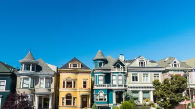
Some of the world's most walkable cities, like London, New York and San Francisco, are actually hostile territory for drivers. As a result, people get around on foot, by cab or via mass transit.
Through a positive feedback loop, pedestrians abound in neighborhoods where walking is much more pleasant than driving. Walkable communities tend to limit traffic volume, which creates a more enjoyable, safe and healthy streetscape, which in turn attracts more pedestrians. In autocentric communities, on the other hand, it is usually easiest to just hop in the car.
The Charter of the New Urbanism asserts that "communities should be designed for the pedestrian and transit as well as the car". This is a noble goal, and many new developments in California (both New Urbanist and others) offer rail access and a network of sidewalks. The challenge has been the "as well as the car" clause. In southern California, planners are bending over backwards to accommodate a rapidly increasing number of vehicles. In an effort to keep traffic flowing smoothly, they are building even wider roads and larger parking lots, making things way too easy for drivers. They are by default creating autocentric environments, regardless of the number of sidewalks included. Multi-lane arterials are about as inviting to pedestrians as sidewalk-rimmed freeways.
So, is there a way to "acknowledge the car" without constructing enormous suburban throughways? While reducing car use sounds cliché, planners do need to provide some disincentives for driving. For example, the City of Berkeley provides very limited parking, both downtown and near the University of California campus. After about a week of driving in circles and $40 parking tickets, new residents soon learn that it is much easier to walk, bike or take the bus. Because so many residents use alternate means of transportation, traffic is usually not gridlocked, even though most streets are quite narrow. Berkeley also has a good old-fashioned urban street grid, which serves to diffuse traffic among countless side streets (all of which are walkable, by the way).
One encouraging sign is the "New Alternatives to Arterials" workshop that was held last fall in Boulder, CO, currently featured in an article on the Congress for the New Urbanism home page. The article concedes that these high-speed roadways are entirely inconsistent with pedestrian-friendly streets.

Two Cheers For the Planners’ Pledge
A “Planners’ Pledge” created by some of the leading authorities on planning sets forth a bold urbanist agenda- even if not every idea in the pledge is equally useful in all cities.
A Better Understanding of Smart Growth Benefits
Smart Growth creates compact, multimodal communities where residents consume less land, drive less, and rely more on non-auto modes. Planners have important stories to tell about the benefits of Smart Growth.

200-Acre Traditional Neighborhood Development Coming to Northwest Arkansas
A local group recently completed the purchase of 200 acres near Rogers, in Benton County, Arkansas, that will become a master-planned, mixed-use neighborhood called Warren Park.

Maui's Vacation Rental Debate Turns Ugly
Verbal attacks, misinformation campaigns and fistfights plague a high-stakes debate to convert thousands of vacation rentals into long-term housing.

Planetizen Federal Action Tracker
A weekly monitor of how Trump’s orders and actions are impacting planners and planning in America.

In Urban Planning, AI Prompting Could be the New Design Thinking
Creativity has long been key to great urban design. What if we see AI as our new creative partner?

King County Supportive Housing Program Offers Hope for Unhoused Residents
The county is taking a ‘Housing First’ approach that prioritizes getting people into housing, then offering wraparound supportive services.

Researchers Use AI to Get Clearer Picture of US Housing
Analysts are using artificial intelligence to supercharge their research by allowing them to comb through data faster. Though these AI tools can be error prone, they save time and housing researchers are optimistic about the future.

Making Shared Micromobility More Inclusive
Cities and shared mobility system operators can do more to include people with disabilities in planning and operations, per a new report.
Urban Design for Planners 1: Software Tools
This six-course series explores essential urban design concepts using open source software and equips planners with the tools they need to participate fully in the urban design process.
Planning for Universal Design
Learn the tools for implementing Universal Design in planning regulations.
planning NEXT
Appalachian Highlands Housing Partners
Mpact (founded as Rail~Volution)
City of Camden Redevelopment Agency
City of Astoria
City of Portland
City of Laramie