


Mapping

The Gig Economy for Mapping
A new startup wants to use blockchain and the Uber model to create free, open-source maps.

Mapping All the Land Uses in the Lower 48
A massive data visualization project illuminates the land uses that define the United States.
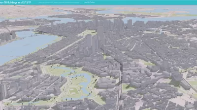
New Citywide Mapping Tool Marks a New Era for Planning in Boston
The Boston Planning & Development Agency released a powerful new map of the entire city—complete with layers like shadows, flood plains, and zoning districts—to the public.

A Land-Management Plan for Catholic Properties Around the World
One of the largest landowners in the world—historically known for creating maps of the Earth—the Church doesn't yet have a cohesive understanding of its global footprint.

Wine Country Wildfires Put Spotlight on Transmission Lines
No cause has yet been attributed to California's deadliest wildfires, but the connections to fallen power lines and exploding transformers, maintained by PG&E, have been exposed in a series of reports by the Bay Area News Group.

Take a LiDAR Tour of Dublin
The potential of Light Detection and Ranging (LiDAR) data to redefine mapping and modeling will be on display in the city of Dublin, Ireland, after NYU researchers released the largest ever LiDAR data set.

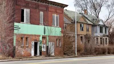
Who's Mapping Gentrification, and Where?
In these cities, data on gentrification has been compiled to build mapping tools documenting the process. The hope is to identify neighborhoods where low-income residents are at risk of displacement.
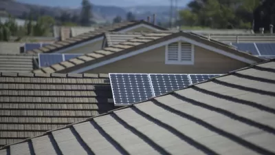
Mapping Rooftop Solar to Make It a Social Norm
Debuted in 2015, Google's Project Sunroof is designed make it easier for homeowners to go solar. Now the tool is harnessing peer pressure to "create a social norm" around solar.

New Tool Prepares Rhode Island for Rising Seas
A new mapping tool shows the potential devastation along the Rhode Island coast caused by rising waters from climate change and storm surges.
How Well Do You Know Your City's Boundaries?
A new crowdsourced map projects asks people to draw their city limits from memory.

Friday Funny: Sheep View Goes Where Google Street View Can't
Some local residents of the Faroe Islands created Sheep View 360 to document the 18 rocky islands that make up their home—and now Google is lending a hand.
Op-Ed: Tech Can Enhance Parks
In the traditional view, nature and digital technology clash. But for many people, tech can offer ways to better engage with parks.
Facebook Is Mapping the World's Buildings
A mapping project lead by Facebook's Connectivity Lab is gathering data from all over the atmosphere, and beyond, to make a comprehensive map of the world's buildings.

Visualizing Global Urban Growth Through 2030
Geographer Duncan Smith mapped the predicted trajectory of worldwide urban growth from 1950 through 2030. Concentric circles of different shades show where and when growth was (or will be) the most dramatic.

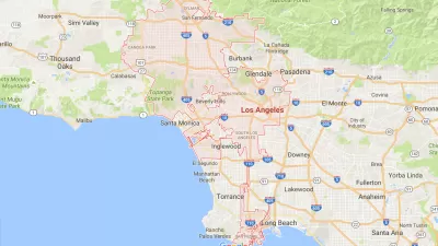
Where Will Gentrification Happen Next?
This map tool hows gentrification-related statistics by Bay Area neighborhood, helping communities guess where the heaviest gentrification will occur.
Google Debuts Rooftop Solar Mapping Tool
Currently in its early stages, Project Sunroof tracks how much sun every roof receives. Then it estimates the costs and savings if rooftop solar were installed. Right now, the tool only covers the Bay Area, Fresno, and Boston.
A Central Hub for Open Data
Designed by researchers at the University of Chicago, the Plenario platform gathers all available open data for a specific area. Then it presents the data in an easy-to-use format.
Map Depicts Nationwide Geography of Inequality
An analysis and accompanying interactive map from the Urban Institute show where the nation's richest and poorest tend to live. The map tells a tale of deeply ingrained wealth segregation.

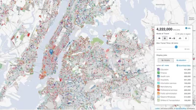
New Mapping Tools Shows How to Access Activities by Various Modes
The Urban Accessibility Explorer is an easy-to-use mapping system that measures the number of activities that can be reached by residents of specified neighborhoods within a given amount of travel time, by a particular mode and time of day.
Friday Eye Candy: Full-Color, HD Videos Taken from Space
For the first time, full-color videos of the earth's surface will be made available to the public, with added options for paying customers. The imagery comes from two cameras on the International Space Station.
City of Costa Mesa
Licking County
Barrett Planning Group LLC
HUD's Office of Policy Development and Research
Mpact Transit + Community
HUD's Office of Policy Development and Research
City of Universal City TX
ULI Northwest Arkansas
Town of Zionsville
Urban Design for Planners 1: Software Tools
This six-course series explores essential urban design concepts using open source software and equips planners with the tools they need to participate fully in the urban design process.
Planning for Universal Design
Learn the tools for implementing Universal Design in planning regulations.


