


An interview with Houston Planning Director Patrick Walsh, conducted after Hurricane Harvey ravaged the city and reduced its planning and infrastructure to a talking point for pundits. It's time to let the locals do the talking.
Even before Hurricane Harvey hit south Texas, the city of Houston was already planning big changes. The famously laissez faire city adopted its first general plan in 2015. Programs to encourage walkability and density were already underway. Public transit projects were already influencing development. Concerns about urban sprawl were already well known. The city was even facing new concerns about gentrification and durable concerns about socioeconomic disparities. Planning Director Patrick Walsh was already working on all of these issues.
Enter the wrath of nature. It's hard to plan a city when a good portion of it is underwater and a good portion of its citizens suffering mightily. It's easy to speculate on whether generations of relatively unhindered and unplanned growth made the damage much worse than it otherwise might have been. And it's imperative to consider how the future growth of the city and region can be directed to avoid such devastation in the future. Josh Stephens spoke with Walsh about these issues and more for Planetizen's "Planners Across America" series.
How did Hurricane Harvey affect you and your department?
Obviously Harvey was an epic event for Houston. A lot of people suffered a lot of damage.
The city overall has been actively engaged in the immediate recovery efforts in terms of things like picking up the debris and providing housing for people who lost their homes. We were active as a department during the storm in a variety of ways. Our mapping group was at the Houston Emergency Center on a 24/7 basis for about ten days supporting the 9-1-1 call center with mapping-related services. Police and fire responses were supported by our mapping group.
While there's been tremendous tragedy, there's also been incredible unity and heartwarming stories of neighbors helping neighbors, and strangers helping strangers. In some of the harder hit area, roving bands of volunteers were walking up to homes of total strangers and offering to spend hours of back-breaking work to help out people they had never met.
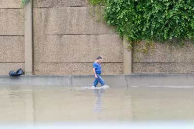
At this point, Houston is very much open for business. A significant amount of debris has been removed. Many businesses are open. Somewhere between 5 and 15 percent of our single-family homes actually had rising water in them. That means 85-95 percent of our single-family homes came out of the flood without being flooded. We have a lot of people who still need a lot of help, and we are working on that.
What we're seeing now is a real priority has been placed, from the mayor on down, on how we make a more resilient city—how do we grow in a smarter way?
Houston has its share of socioeconomic separation. How discriminatory were the floods?
Harvey was an equal-opportunity disruptor. Harvey hit a lot of areas of significant wealth, and it hit disadvantaged areas. People may have seen a photo that was widely distributed of former mayor Bill White, who's a former energy company executive, wading through water as he evacuated his own home. On the other hand, there were some more disadvantaged areas that were hit quite hard. Kashmere Gardens on the northeast side and the East Houston area were really devastated.
Even though some lower-income areas fared okay in terms of raw damage, in many cases they were very hard hit in terms of their ability to make ends meet. One of the hard things, especially for people in the service industry, was that our restaurants were down for a week. Many wait staff, bus boys, and others are dependent on a month-to-month basis with a steady income, and that income stopped while the city was shut down.
There's been a lot of speculation about whether urban planning, in the city and regionwide, "caused" the flooding. How do you feel about that speculation?
I do want to dispel the myth that zoning had something to do with flooding in Harvey. Mayor Turner is absolutely right that if we were a zoned city, we would have been a zoned city that flooded. We had roughly three feet of rain across Harris County over five days. By some media reports this was the heaviest rainfall ever recorded in the continental United States. We would have flooded no matter what.
There are a lot of big policy questions that need to be examined coming out of Harvey. We do need to look at our detention requirements for new subdivisions and make sure that they are fully mitigating their impervious cover increases. We need to look at things like, to what degree will we allow construction in a floodplain at all or reconstruction of existing homes. Our buyout policies need to be revisited.
We drain from west to east along a system of nine bayous. We have had explosive growth along the west side and north side of the Houston region. That growth pattern is driven primarily by transportation investments. If you build highway capacity, you will see a response to this capacity through the construction of low-density suburban-style development.
One of the questions we need to be asking ourselves is, is there a smarter and more resilient growth pattern that could be achieved if we focus transportation investments more in the core rather than in the periphery? Growing up, not out, is a more resilient and smarter way for this region to grow.
It's going to require tremendous political will to see these things through. Certainly elected officials are expressing this will, and that's the good news. One of the challenges of the politics behind flooding is that when flooding goes away and the skies are clear, the urgency can diminish. What we will be watching for over the coming months and years is whether we can sustain this degree of urgency.
Houston recently adopted its first general plan. How is that going? Has it blown people's minds? Does the flooding have any impact on how that plan is going to function?
In 2015, the Houston City Council adopted Plan Houston as its first general plan. That was huge. There had been a number of attempts at a general plan through the decades, going back at least to the 1920s. None of them got across the finish line.
Prior to Plan Houston's adoption, Houston did not have any city council-level goals or strategies. We were driven primarily by the vision that was provided by the mayor at the time. We now at least have a comprehensive description of what we want to be in the future. I see this as a sign that Houston's famously market-based culture is steadily recognizing good planning as a means to maximize opportunities, rather than as a threat that controls development.
Plan Houston is very high-level. The whole text is about 20 pages. The idea was to set some goalposts in a broad way of visions and strategies, and on an annual basis we would be using Plan Houston as a guidepost as we develop our work plans for the year. As we develop our annual budget, we're going to be referencing Plan Houston as a guide.
What other innovations were underway before the hurricane hit?
The first innovation is Mayor Turner's Complete Communities initiative. Complete Communities is about ensuring all neighborhoods, including our underesourced communities, have access to all the resources that people need to thrive. This is the first time the city has had this kind of high-profile, holistic, and focused effort to do neighborhood planning at this level in our underserved communities.
Mayor Turner has been very clear that we need to create equitable neighborhoods that are well connected by transit, that have long-term affordable housing and that have access a variety of quality services, be it education, social services, libraries, parks. We need to think holistically, not just about infrastructure and public safety – so we're looking beyond some of the core services that the city is traditionally tasked with—but getting into questions like, how do we partner with our education providers, like the Houston Independent School District?
Another is our Walkable Places project. The city of Houston has a somewhat suburban-style development code. Our code requires standardized building setbacks and somewhat one-size-fits-all parking requirements, neither of which are not especially sensitive to locational context. In our walkable urban areas we need a development code that encourages an urban form supportive of walkable places. We have a number of areas, especially inside the 610 loop, that are walkable or have good bones for walkability, and we need to align our development regulations to encourage and strengthen walkability in those places. We want to do better placemaking.
We have convened a committee of about 20 or so stakeholders across the community. They are coming up with, I think, an exciting possibility where an applicant could apply for a unique set of development rules to support the creation of a walkable place. The rules would ensure that all the development and redevelopment would be encourage a more walkable form that is sensitive to local context and supported by local property owners. The new rules would offer a new flexibility in our code, and will provide assurance to developers that when they build that walkable form, their neighbors will also participate.
With Houston's growth, there's been some tension around gentrification and displacement, the rise of townhomes where there used to be low-income houses. How does the department address those tensions?
The issue of redevelopment and gentrification is challenging in Houston. We are seeing reinvestment in some of our more disadvantaged areas as the market starts to drive growth beyond what used to be the frontier of Houston Heights or Montrose. Now we're seeing the impacts of gentrification creeping into the Third Ward and even the Fifth Ward.
On the one hand, some see this as an opportunity to revitalize these areas. On the other hand, there is pushback from neighborhoods that are concerned about the change of character, loss of history and culture, and other impacts. They are concerned about drainage and traffic as these areas get more dense. The complaints often focus on the townhomes with individual forward-facing driveways, which interrupt on-street parking and eliminate mature street trees.
We are not a zoned city, so we do not have the same level of control to secure neighborhood stability and manage redevelopment in these neighborhoods. But we do have a number of tools that help. Usually we rely on the neighborhoods opting into, for instance, local lot-size protections and building-line limits that our codes allow. Rather than the city dictating from the top-down, we have a more market-based, organic approach.
Sometimes we hear complaints that these are not strong enough programs. Residents complain that in order to apply a lot-size requirement, it creates division within neighborhoods, as many people are hesitant to pit neighborhood against neighbor so they end up not applying for those protections. It's a tough balance.
What is your background and how did you end up where you are today?
I'm confused—I can't tell if I'm planner or an engineer! I'm a licensed civil engineer, and my background by education and much of my career is in engineering. I had the opportunity to peel away from the technical side of engineering and do policy work in my previous stint in the city of Sugar Land, Texas. I became Sugar Land's transportation director and then director of transportation and long-range planning. Overall, I enjoy the gray area of policy more than I do the black-and-white of engineering.
Coming here to Houston was a great opportunity for me. It's my hometown; it's where I live. I'm more of an urban guy when it comes down to it.
I was hired as deputy director of Houston's Planning and Development Department. Unbeknownst to me, the previous director had arrangements to announce her retirement two days later. That was quite a shock. I quickly came to the conclusion that I did want the job, and within five months I had the privilege of being confirmed as director by City Council. For the first year, I felt like I had grabbed on to the back bumper of a moving vehicle. It was quite a scramble. I held on by my fingertips, and eventually felt like I had my hands on the wheel. The job has been tremendously rewarding, and I love what I do.
Conducted in early October, this interview has been edited and condensed.
Houston Planning Director Patrick Walsh Passes Away at 45
Sad news for the planning community. Houston Planning Director Patrick Walsh, who took leave from his position earlier this year after a cancer diagnosis, has passed away.

Stampede of New Residents Challenges Fort Worth
An interview with Fort Worth Planning and Development Director Randle Harwood on the planning practices and ideas driving the future of one of the nation's fastest growing cities.

Planning Director Susan Anderson Separates Fact from Fiction in Portland(ia)
Planetizen's "Planners Across America" series continues in the city that put many contemporary best planning practices on the map: Portland, Oregon.

Depopulation Patterns Get Weird
A recent ranking of “declining” cities heavily features some of the most expensive cities in the country — including New York City and a half-dozen in the San Francisco Bay Area.

California Exodus: Population Drops Below 39 Million
Never mind the 40 million that demographers predicted the Golden State would reach by 2018. The state's population dipped below 39 million to 38.965 million last July, according to Census data released in March, the lowest since 2015.

Chicago to Turn High-Rise Offices into Housing
Four commercial buildings in the Chicago Loop have been approved for redevelopment into housing in a bid to revitalize the city’s downtown post-pandemic.

New Park Opens in the Santa Clarita Valley
The City of Santa Clarita just celebrated the grand opening of its 38th park, the 10.5-acre Skyline Ranch Park.

U.S. Supreme Court: California's Impact Fees May Violate Takings Clause
A California property owner took El Dorado County to state court after paying a traffic impact fee he felt was exorbitant. He lost in trial court, appellate court, and the California Supreme Court denied review. Then the U.S. Supreme Court acted.

How Urban Form Impacts Housing Affordability
The way we design cities affects housing costs differently than you might think.
City of Costa Mesa
Licking County
Barrett Planning Group LLC
HUD's Office of Policy Development and Research
Mpact Transit + Community
HUD's Office of Policy Development and Research
City of Universal City TX
ULI Northwest Arkansas
Town of Zionsville
Write for Planetizen
Urban Design for Planners 1: Software Tools
This six-course series explores essential urban design concepts using open source software and equips planners with the tools they need to participate fully in the urban design process.
Planning for Universal Design
Learn the tools for implementing Universal Design in planning regulations.