


Open Source
Meet Google's Open Source, Time-Traveling Map
All historic maps are welcome in Google's open source machine learning project.

Uber Releases Open-Source Mapping Tool
Individuals and major companies alike have already found a variety of applications for the software.

Mapzen to Close at the End of January
The mapping community was sad to learn this week that the Mapzen open source mapping platform would cease operation at the end of the month. Many of Mapzen's open source tools will live on, for those that now how to use them.

'Housing Insights' Mapping Tool Designed to Preserve Subsidized Housing in D.C.
The Housing Insights team of volunteer civic hackers hopes you'll use their software in other cities, too.

Bikes Have the Attention of the Ford Motor Company
The age-old conflict between cars and bikes finally has the attention of one of the giants. Ford's Info Cycle project mounts sensors on street bikes to map out how multi-modal city travelers move around.
Cities Map—and Track Benefits—of Urban Forest
OpenTreeMap allows cities to inventory trees and see the environmental and economic benefits.
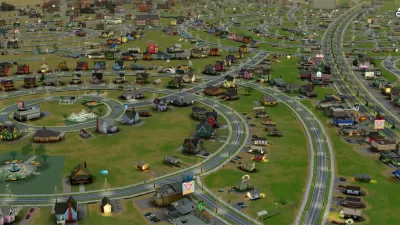
Visualizing Big Data In Your Own SimCity World
Two former Mozilla engineers strive to merge big data with a 3D model of London and, potentially, other cities.
Liberating High-Quality Home Design
Does not having the money to hire a world-class architect mean you shouldn't be able to build a well-designed house? A new website seeks to make high-quality design accessible to the masses with open source architecture.
Urban Design in the New Soft City
Carl Skelton argues that the public needs new tools of citizenship to participate fully in the digital cities of the near future.
Bridging the Gap Between the Virtual World and Reality
A young artist in New Orleans launches a social experiment on the built environment, turning the walls of the city's buildings into a public forum.
Can V-Poles Replace Urban Clutter?
Vancouver will attempt to address urban clutter with innovative multifunctional utility poles that house Wi-Fi and telecom services, as well as other amenities, designed by none other than famed novelist Douglas Coupland.
Building Codes Should Not Be Privately Copyrighted
Public domain activist Carl Malamud explains in this brief talk why he believes building, fire and safety codes should be taken out of the hands of the private companies that distribute them and made publicly accessible.
Using Public Data to Make Easy "Next Bus" Displays
At the recent RailVolution conference in Portland, OR, Chris Smith of Portland Transport showed off a cheap and simple display device that uses open source data to display transit times in public spaces. His price? $200.
Sharing the Civic Commons
Civic Commons is a new non-profit that facilitates the sharing of information and knowledge on open city initiatives for open, data-driven, and collaborative city services.
Recovery Through the Open Source Design Movement
With the devastation in Haiti fresh in mind, Good's Alissa Walker takes a look at the growing practice of sharing design ideas.
Atlanta To Map Itself
A group of 200 volunteers with GPS devices will walk the streets of Atlanta this weekend to create a community-owned map of the city and its intricate details.
Open City Data, But How Much?
Opening city data to the public was a relatively new idea when the District of Columbia began publishing its data streams online recently. As applications using the data developed, some in the District got a little weary of the idea.
Open Source for Planners
Mark Gorton, creator of Limewire started developing his GeoServer software in 1999. Recently Portland adopted the software to plan bus routes. Gorton wants to foster a new revolution in participatory planning.
City of Costa Mesa
Licking County
Barrett Planning Group LLC
HUD's Office of Policy Development and Research
Mpact Transit + Community
HUD's Office of Policy Development and Research
City of Universal City TX
ULI Northwest Arkansas
Town of Zionsville
Urban Design for Planners 1: Software Tools
This six-course series explores essential urban design concepts using open source software and equips planners with the tools they need to participate fully in the urban design process.
Planning for Universal Design
Learn the tools for implementing Universal Design in planning regulations.


