


Google Earth

Visualizing Worst-Case Scenario Sea Level Rise on the Texas Coast
Much of the state political leadership in Texas has been slow to accept the existence of climate change, much less the role of the state's economy, land use, and infrastructure planning in exacerbating the crisis. Maybe this will help wake them up?
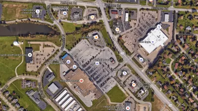
Retail Parking: A View from Google Earth
Google Earth can be a useful tool for understanding how parking is being used in your community and to identify where over- or under-utilization occurs.
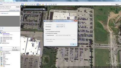
Using Google Earth to Understand Parking Utilization
As planners we use maps on a daily basis. This article shares how to find the date and time that a Google Earth image was taken, which can be helpful in undertaking site analysis and understanding parking utilization.
Watch North America's Cities Grow Up
A Canadian real estate startup has created striking animated 3-D visualizations of the evolution of the skylines in cities such as New York, Los Angeles, San Francisco, and Chicago.
Mapping Chicago's Growing Cornucopia of Urban Gardens
In Chicago, like in many cities, local food production comes in many forms, from small backyard crops to community gardens. Researchers are now using Google Earth to paint a more accurate picture of food production at different scales.
How Well do You Know the World?
The Atlantic offers a brain teaser tailor made for the readers of Planetizen.
Dutch Censorship is Drawn with Geometric Aesthetics
Samuel Medina describes how the Dutch use stylistic aesthetics to disguise sections of their satellite images to ward off national threats, as portrayed in Mishka Henner's new book, Dutch Landscapes.
Mapping Cities in India
With high development occurring in India, new mapping technologies can greatly help smart growth in the burgeoning country.
Google Earth Reveals Un-Permitted Pools
A town in New York has been using satellite imagery from Google Earth to identify illegally-built pools.
The 10 Most Important Maps in the World
This article from The Daily Mail takes a historical look at ten maps that changed the world.
Mapping Climate Change
Climate change is now being visualized in 3D maps on Google Earth.
Google Earth Gets Animated
Researchers from Georgia Tech are blending real-time video with imagery from Google Earth to create dynamic visualizations of urban places. [Video]
Watch the Land Change Through Google Earth Images
These videos show images of locations that have seen significant change over the past few years as seen through Google Earth images, from Dubai's manmade archipelago to Utah's disappearing Lake Powell.
Google Earth Takes You Back In Time
In the new version of Google Earth, you can compare aerial imagery from the past with current development on the site.
Google Earth Goes into the Deep Blue
New updates to the online visualization program Google Earth add oceans to the image-based virtual version of the planet.
Google Earth First!
Environmental activists and other organizations are using Google Earth to document environmental damage and to promote their various causes.
'The Earth in Your Pocket'
That's how developers at Google describe the release of Google Earth for the iPhone. Boing Boing's Joel Johnson wonders why it wasn't released for Android first.
Top Ten Reasons...
Over the past three months, my girlfriend and I have made three trips to the suburbs of Miami. Twice to the Whole Foods we desperately lack on Miami Beach (Yes, Wild Oats is okay, but for us food snobs it just does not compare) and once to the brand new, soul-killing, 283,000 square foot IKEA to partially outfit our 450 square foot South Beach studio apartment.
City of Costa Mesa
Licking County
Barrett Planning Group LLC
HUD's Office of Policy Development and Research
Mpact Transit + Community
HUD's Office of Policy Development and Research
Tufts University, Department of Urban and Environmental Policy & Planning
City of Universal City TX
ULI Northwest Arkansas
Urban Design for Planners 1: Software Tools
This six-course series explores essential urban design concepts using open source software and equips planners with the tools they need to participate fully in the urban design process.
Planning for Universal Design
Learn the tools for implementing Universal Design in planning regulations.


