


3d

Take a LiDAR Tour of Dublin
The potential of Light Detection and Ranging (LiDAR) data to redefine mapping and modeling will be on display in the city of Dublin, Ireland, after NYU researchers released the largest ever LiDAR data set.
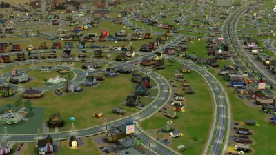
Visualizing Big Data In Your Own SimCity World
Two former Mozilla engineers strive to merge big data with a 3D model of London and, potentially, other cities.
Creating a 3D Record of Africa's Heritage Sites
Fast Company points to a project at the University of Cape Town which seeks to create 3-D renderings of Africa's endangered monuments and heritage sites.
Chinatown: The Video Game
"Participatory Chinatown" is a computer game designed to increase public participation in the planning process in Boston.
Building Cities Out of Pictures
Researchers are working on technology to help create 3D models of buildings and places by using large collections of digital photos.
3D Motown
The team at Google has released a 3D model of Detroit.
Mapping Climate Change
Climate change is now being visualized in 3D maps on Google Earth.
Creating Virtual City Tours Through 'Photo Tourism'
By combing through images on Flickr, a team of researchers has created a 3-D model of the city of Rome constructed from 150,000 tourist snapshots.
Military Mapping the Threats and Advantages of Urban Areas
The U.S. Military's Defense Advanced Research Projects Agency is investing in a program that looks to create 3D imagery of urban areas and the common spaces and objects that could pose threats or provide advantages to military operations.
Mapping the Catacombs
A new mapping project is creating a comprehensive 3D image of the catacombs beneath Rome.
City of Costa Mesa
Licking County
Barrett Planning Group LLC
HUD's Office of Policy Development and Research
Mpact Transit + Community
HUD's Office of Policy Development and Research
City of Universal City TX
ULI Northwest Arkansas
Town of Zionsville
Urban Design for Planners 1: Software Tools
This six-course series explores essential urban design concepts using open source software and equips planners with the tools they need to participate fully in the urban design process.
Planning for Universal Design
Learn the tools for implementing Universal Design in planning regulations.


