


Chi.Streetsblog
Early Reviews Are In: Chicago's New Transit App Makes it Easy to Pay the Fare
The Ventra app hits the streets—or the tracks, perhaps—this week. Steven Vance of Streetsblog Chicago has already tested the new tool.
Chicago Approves Big Expansion of TOD Ordinance
Ten times more land in Chicago is now designated for transit oriented development—affording new development reduced parking requirements, density bonuses for affordable housing, and new strength for the city's Pedestrian Street design regulations.

'Grow Chicago' Shows the How and Why of Transit Oriented Development
Chicago's Metropolitan Planning Council has released a new toolbox full of interactive features intended to assist transit oriented development.
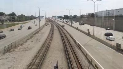
Op-Ed: Airport Express Train Unnecessary in Chicago
Plans to construct a prestigious express line to O'Hare airport may be overkill. The existing Blue Line, which could benefit from some investment, already connects downtown Chicago and the airport.
New Section of the Chicago Riverwalk Open to the Public
A newly opened section of the Chicago Riverwalk lets the public get up close and personal with the Chicago River. And there's more to come.
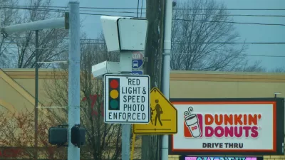
To Protect Pedestrians, Keep the Cameras
Active Transportation Alliance, a Chicago pedestrian advocacy group, urges Mayor Rahm Emanuel to improve red light cameras rather than remove them. Despite complaints from drivers, well-advertised cameras can reduce pedestrian fatalities.
State Bill Would Add TIFs Along Transit Lines in Chicago
Expanded use of tax increment financing is on the table in Chicago—a city that invests less than its peers on building and running transit.
Report: Downzoning Fails Demographics on Chicago's Northside
Lakeview, on the North Side of Chicago lost one percent of its total households between 2000 and 2011, while its population grew 11 percent. That means more families, but according to a new report, the neighborhood might need new zoning to keep up.
'Lincoln Hub': A Polka Dot Makeover for Chicago Intersection
The intersection of Lincoln Ave, Southport Avenue, and Wellington Avenue in the South Lakeview neighborhood of Chicago is in the process of a major upgrade in pedestrian-friendly placemaking.

Details on Chicago's First Shared Street
Planners are crafting the details of Chicago's first shared street, where pedestrians will rule.
Progress for Cook County's Long Range Transportation Plan; Funding Questions Remain
Chicago's home county this year launched its first transportation since 1940. Initial outreach efforts have produced a draft vision statement and four planning scenarios.
A Buffer is Better
What's the best street design to keep bicyclists safely out of the door zone? A buffered bike lane beats a conventional bike lane or "wide curb lane" according to a recent study published in TRB, based on observations in Chicago and Cambridge, Mass.
Speed Cameras: Working in Chicago; Needed in Philadelphia
In Chicago, speed cameras are proving effective at reducing speeds; in Philadelphia, a police commissioner is lobbying the state to allow the implementation of the cameras.
A Call for Local Architects to 'Redefine the Drive' in Chicago
A local architect produced a DIY design to push the Illinois Department of Transportation to think big with the "Redefine the Drive" project on North Lake Shore Drive. With the proposal: invitations for more local designers to participate.
Illinois Bike Transportation Plan Could Be a Game Changer
The Illinois Bike Transportation Plan has the potential to impact the design of state roads in the purview of the Illinois Department of Transportation: 2,775 miles, or nine percent of the total mileage, of road in the Chigagoland region.
Checking in on Chicago’s Riverwalk Extension Plans
The already brilliant city of Chicago is soon to get another big draw—the extension of a riverwalk promenade between State and Lake streets.
First Transportation Plan Since 1940 Launches in Chicago’s Cook County
Cook County is in the early stages of public outreach for its first transportation plan since the 1940 “Highway Plan for Cook County.”
How to Gain 21 Million Transit Trips a Year in Chicago?
At a recent hearing of the Northeastern Illinois Public Transit Task Force, experts like Peter Skosey made the case for the types of changes necessary to meet Chicago’s goals for increased transit ridership, focusing on transit oriented development.
Illinois Betting On Tolls to Cover Highway Costs
The state of Illinois is actively pushing two highway projects that might fail to pencil-out for users and for state taxpayers.
Chicago Doesn't Have to Look Far to Find New DOT Chief
When Mayor Rahm Emanuel sought out his first transportation chief, he lured Gabe Klein from Washington D.C. This week it was announced that Klein's successor had been found much closer to home: the city's transit authority.
City of Costa Mesa
Licking County
Barrett Planning Group LLC
HUD's Office of Policy Development and Research
Mpact Transit + Community
HUD's Office of Policy Development and Research
Tufts University, Department of Urban and Environmental Policy & Planning
City of Universal City TX
ULI Northwest Arkansas
Urban Design for Planners 1: Software Tools
This six-course series explores essential urban design concepts using open source software and equips planners with the tools they need to participate fully in the urban design process.
Planning for Universal Design
Learn the tools for implementing Universal Design in planning regulations.


