


Geographic Information Systems

What Is GIS?
GIS software, which combines location information with data about a range of other attributes, has become an indispensable tool for mapping and spatial analysis in urban planning and dozens of other fields.

Charleston Launches Affordable Housing Dashboard
The city’s new online tool shares information about affordable housing projects to help stakeholders understand where and how affordable housing is being built and distributed.

How the National Park Service Uses GIS
A new book demonstrates how the National Park Service uses GIS technology to meet its mission and showcases a selection of maps used for effectively managing national parks.

Growing Use of Trails Highlights the Work of Trail Planners
Trails have become very popular during the COVID-19 pandemic. Find out more about how trail planners in L.A. County plan for multi-use trails and promote the safe use of trails.

How GIS Helps Plan Parks
With constrained budgets, a geographic information system (GIS) may seem like a luxury for parks agencies. But to perform data-driven planning and advance park equity, GIS is an indispensable tool.

GIS Community Brings Maps to the Coronavirus Fight
Data-Smart City Solutions at the Harvard Kennedy School is monitoring the use of GIS technology to inform the public health response to the coronavirus pandemic.

Visualizing the Coronavirus Pandemic
Mapping of the crisis is producing a fascinating and important trove of cartographic records.

Esri Sets Up COVID-19 GIS Hub
The planning profession can contribute to the worldwide fight to control the spread of COVID-19. GIS technology, for instance, allows real-time monitoring of the pandemic.
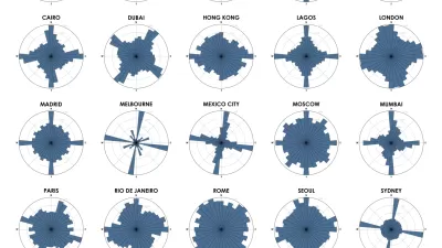
Chart Your City's Street Network to Understand its Logic
The roads in your city might conform to a grid, or they might divert around natural resources or landmarks. A new tool aims to help you visualize the "hidden logic" behind urban growth.
Three Ways to Make GIS as Powerful as Possible
These days, cities are expected to make the most of open data and spatial visualization technologies.

A Land-Management Plan for Catholic Properties Around the World
One of the largest landowners in the world—historically known for creating maps of the Earth—the Church doesn't yet have a cohesive understanding of its global footprint.
India Encourages Monster Master Planning Effort
Planners in search of work might want to consider looking in India. As Nate Berg reports, the Indian government is hoping a new technology initiative will catalyze master planning efforts in 7,935 cities and towns across the country.
Leading Thinkers in Urban Planning & Technology
Planetizen founding Editor Chris Steins offers his evaluation of the top 25 thinkers at the intersection of planning and technology.
City of Costa Mesa
Licking County
Barrett Planning Group LLC
HUD's Office of Policy Development and Research
Mpact Transit + Community
HUD's Office of Policy Development and Research
Tufts University, Department of Urban and Environmental Policy & Planning
City of Universal City TX
ULI Northwest Arkansas
Urban Design for Planners 1: Software Tools
This six-course series explores essential urban design concepts using open source software and equips planners with the tools they need to participate fully in the urban design process.
Planning for Universal Design
Learn the tools for implementing Universal Design in planning regulations.


