


Street Grids

The Dots of Connectivity and Broken Cultural Links
Connectivity is not just a question of geometry, according to this article by Fanis Grammenos. It's critical to consider what people connect for and how.

A 'Cul-De-Tax' for the Cul-De-Sac?
A recent study studying the contemporary planning profession's rejection of the cul-de-sac includes a proposal to create more economic disincentives for inefficient street grid patterns.

The World's Streets Are Becoming Less Connected, Study Shows
The world is sprawling as it develops, according to ambitious new research.

How an Urban Grid Becomes a Maze
Many rational, open grids can seem like a labyrinth to users. The labyrinth has emerged as an unplanned consequence of the evolution of cities, but solutions like GPS navigation and autonomous vehicles could mean relief.
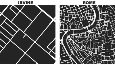
Friday Eye Candy: Comparing a Square Mile of the World's Famous Cities
Street networks and city blocks, reduced to their fundamental attributes, reveal the vast differences between cities.
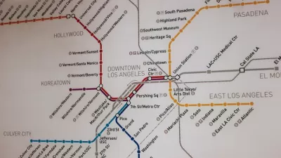
Pop Quiz: Can You Name Cities from their Transit Maps?
What better way to wind down from a long week thinking about cities and maps and transportation than by taking a quiz to show off your knowledge of cities and maps and transportation?
The Unique 'Fingerprints' of 131 Cities
An article on big think examines a project to find the unique qualities of urban street grids as an exercise in the potential of Big Data.

What Street Grids Reveal About a City
Author and blogger David Prowler takes a lighthearted and pictorial look at what the layout of a town's streets unveils about a city's history and aspirations.
Graphic Reveals Cardinal Orientation of Street Grids
Seth Kadish says he was born with an innate sense of direction. As such, he appreciates street grids oriented to cardinal directions. The phenomena interested him enough to create a graphic that visualizes the orientation of 12 urban areas.
The Rise and Fall of the Cul-de-Sac
In the 1930s, The Federal Housing Authority embraced the trend towards cul-de-sacs, decrying the standard street grid as monotonous and unsafe. Norman Garrick and Wesley Marshall have proven otherwise.
Interactive Map Tracks Growth of Manhattan Grid
This interactive map from The New York Times overlays historic maps with modern-day maps of the city, and shows how the city and its street grid has developed.
New York City's Grid Turns 200
The street grid of New York City was born 200 years ago in an early map of the city.
City of Costa Mesa
Licking County
Barrett Planning Group LLC
HUD's Office of Policy Development and Research
Mpact Transit + Community
HUD's Office of Policy Development and Research
Tufts University, Department of Urban and Environmental Policy & Planning
City of Universal City TX
ULI Northwest Arkansas
Urban Design for Planners 1: Software Tools
This six-course series explores essential urban design concepts using open source software and equips planners with the tools they need to participate fully in the urban design process.
Planning for Universal Design
Learn the tools for implementing Universal Design in planning regulations.


