


Geotagging
Friday Eye Candy: Maps Reveal Differences in How Locals and Tourists See the City
The cities that visitors see will always be different than the city that locals see. A new mapping project reveals the distinctions between the local perspective and the tourist perspective for 136 cities around the globe.

Mapping Interest in All Things Zombie
The three geographers behind the Floating Sheep blog have created a world map of Internet references to zombies.
A Mobile Encyclopedia of Place
An announcement last week indicates that Wikipedia will become the newest player in the increasingly competitive effort to connect virtual information with physical places.
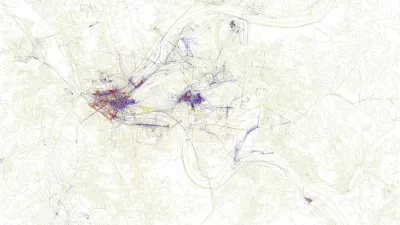
Smarter Transit Routes Through Twitter?
John Pavlus reports on Eric Fischer's use of Twitter's geotagging feature to map the most highly trafficked thoroughfares in several cities. The results are fascinating, and beautiful.
How Mobile Apps Will Change Your City
Gigaom looks at a handful of "augmented reality" apps, both current and projected, that create an interface between the internet and the world around us.
City of Costa Mesa
Licking County
Barrett Planning Group LLC
HUD's Office of Policy Development and Research
Mpact Transit + Community
HUD's Office of Policy Development and Research
Tufts University, Department of Urban and Environmental Policy & Planning
City of Universal City TX
ULI Northwest Arkansas
Urban Design for Planners 1: Software Tools
This six-course series explores essential urban design concepts using open source software and equips planners with the tools they need to participate fully in the urban design process.
Planning for Universal Design
Learn the tools for implementing Universal Design in planning regulations.


