


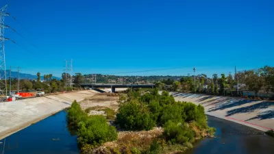
Sometimes it seems like it will never rain again in Los Angeles, but the river running through the city is still a significant flood risk.

"Los Angeles this week received a stark reminder that the river that cuts through the region — much of the year just a trickle — can become a dangerous torrent during periods of intense rain," according to an article by Ben Poston.
The report from the U.S. Army Corps of Engineers found "more than 3,000 parcels north of downtown Los Angeles in neighborhoods such as Atwater Village and Elysian Valley could be submerged by an average of 5 to 10 feet of water in the event of a 100-year storm," reports Poston. Parts of Griffith Park, Glendale, and Burbank are also at risk of significant flooding.
The report means property owners with federally backed mortgages will be required to purchase flood insurance, and new developments will have to conform to new building regulations.
The U.S. Army Corps of Engineers prepared the report as a step toward the massive river restoration project underway in Los Angeles.
FULL STORY: New warnings about risk of major flooding on L.A. River amid new development, revitalization
Cost of River Restoration Project Rising Quickly in Los Angeles
Questions are emerging about the funding equation for an ambitious $1 billion proposal to improve 11 miles of the Los Angeles River through some of the most urban parts of the city.

A New Master Plan for the Los Angeles River
The L.A. County Board of Supervisors voted to approved a new master plan for the L.A. River—the “Reimagined River.”
A Comment for the L.A. River Master Plan
Five themes proposed to achieve justice and sustainability for the Los Angeles River and its surrounding communities.

Depopulation Patterns Get Weird
A recent ranking of “declining” cities heavily features some of the most expensive cities in the country — including New York City and a half-dozen in the San Francisco Bay Area.

California Exodus: Population Drops Below 39 Million
Never mind the 40 million that demographers predicted the Golden State would reach by 2018. The state's population dipped below 39 million to 38.965 million last July, according to Census data released in March, the lowest since 2015.

Chicago to Turn High-Rise Offices into Housing
Four commercial buildings in the Chicago Loop have been approved for redevelopment into housing in a bid to revitalize the city’s downtown post-pandemic.

DC Bikeshare System Breaks Ridership Record
Capital Bikeshare users took over 20,000 rides on one day in March.

EV Infrastructure Booming in Suburbs, Cities Lag Behind
A lack of access to charging infrastructure is holding back EV adoption in many US cities.

Seattle Road Safety Advocates Say Transportation Levy Perpetuates Car-Centric Status Quo
Critics of a proposed $1.3 billion transportation levy say the package isn’t enough to keep up with inflation and rising costs and fails to support a shift away from car-oriented infrastructure.
Barrett Planning Group LLC
City of Cleburne
KTUA Planning and Landscape Architecture
HUD's Office of Policy Development and Research
Mpact Transit + Community
HUD's Office of Policy Development and Research
City of Universal City TX
ULI Northwest Arkansas
City of Laramie, Wyoming
Urban Design for Planners 1: Software Tools
This six-course series explores essential urban design concepts using open source software and equips planners with the tools they need to participate fully in the urban design process.
Planning for Universal Design
Learn the tools for implementing Universal Design in planning regulations.