


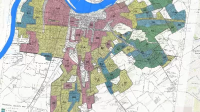
The Mapping Inequality website documents how the liberal ideals of the New Deal devolved into discrimination and inequality.
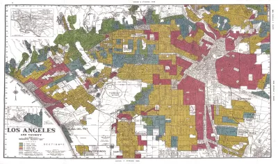
"The maps in this post are part of a grim history," according to an article by Greg Miller. "They were created by a government program in the 1930s and played a role in keeping African Americans and other minorities from owning property in American cities, thereby leaving an indelible mark on the racial and economic history of the United States."
The Mapping Inequality project has gathered these maps and documents, the work of the Home Owners' Loan Corporation (HOLC) during the Great Depression, and placed them online.
Miller explains more of the redlining history of the HOLC, while also sampling specific case studies from cities included in the Mapping Inequality archive—cities such as Los Angeles, Seattle, Wichita, and Portland.
As acknowledged on the Mapping Inequality website, the project combines the work of researchers and students at the University of Richmond, the University of Maryland, Virginia Tech, and Johns Hopkins University.
FULL STORY: Newly Released Maps Show How Housing Discrimination Happened

Reporters Go Undercover to Identify Housing Discrimination
A three-year investigation of the real estate industry on Long Island reveals rampant discriminatory practices and an industry complicit in the segregation of the communities that comprise the region.
Study: Historical Redlining Maps No Longer a Proxy for Black America
Black Americans have moved on from formerly redlined neighborhoods, and other minorities and whites have moved in. The wave of presidential campaigns that have based housing policy proposals on redlining maps might be misguided as a result.

Seattle Exhibit Grapples With Redlining Past and Present
A creative exhibit highlights how redlining and racist exclusion persist today.

Depopulation Patterns Get Weird
A recent ranking of “declining” cities heavily features some of the most expensive cities in the country — including New York City and a half-dozen in the San Francisco Bay Area.

California Exodus: Population Drops Below 39 Million
Never mind the 40 million that demographers predicted the Golden State would reach by 2018. The state's population dipped below 39 million to 38.965 million last July, according to Census data released in March, the lowest since 2015.

Chicago to Turn High-Rise Offices into Housing
Four commercial buildings in the Chicago Loop have been approved for redevelopment into housing in a bid to revitalize the city’s downtown post-pandemic.

Google Maps Introduces New Transit, EV Features
It will now be easier to find electric car charging stations and transit options.

Ohio Lawmakers Propose Incentivizing Housing Production
A proposed bill would take a carrot approach to stimulating housing production through a grant program that would reward cities that implement pro-housing policies.

Chicago Awarded $2M Reconnecting Communities Grant
Community advocates say the city’s plan may not do enough to reverse the negative impacts of a major expressway.
City of Costa Mesa
Licking County
Barrett Planning Group LLC
HUD's Office of Policy Development and Research
Mpact Transit + Community
HUD's Office of Policy Development and Research
City of Universal City TX
ULI Northwest Arkansas
Town of Zionsville
Urban Design for Planners 1: Software Tools
This six-course series explores essential urban design concepts using open source software and equips planners with the tools they need to participate fully in the urban design process.
Planning for Universal Design
Learn the tools for implementing Universal Design in planning regulations.